Scanning laser based large-scale three-dimensional terrain modeling method

A technology for scanning lasers and 3D terrain, which is applied in the field of 3D terrain modeling of probabilistic large-scale environments, and can solve the problems of compressed storage and processing terrain modeling uncertainty terrain modeling algorithm accuracy and computational complexity, and achieves good results. Economic benefits, achieving a good balance, and the effect of broad application prospects

Inactive Publication Date: 2012-12-19
SOUTHEAST UNIV
View PDF2 Cites 36 Cited by
  • Summary
  • Abstract
  • Description
  • Claims
  • Application Information

AI Technical Summary

Problems solved by technology

[0006] The purpose of the present invention is to overcome the existing technical defects, solve the problem of compressed storage and processing of massive sensor data in large-scale three-dimensional terrain modeling based on scanning lasers, the uncertainty of terrain modeling and the accuracy of terrain modeling algorithms In order to achieve the balance between computational complexity and computational complexity, a large-scale 3D terrain modeling method based on low-cost 2D scanning laser is proposed to realize efficient and real-time modeling of field terrain environment

Method used


Image

  • Scanning laser based large-scale three-dimensional terrain modeling method
  • Scanning laser based large-scale three-dimensional terrain modeling method
  • Scanning laser based large-scale three-dimensional terrain modeling method

Examples


Embodiment Construction

[0022] The present invention will be further described below in conjunction with the accompanying drawings and specific embodiments.

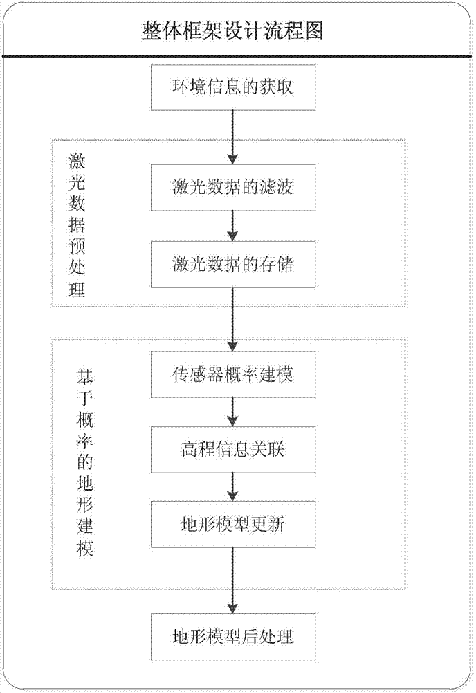
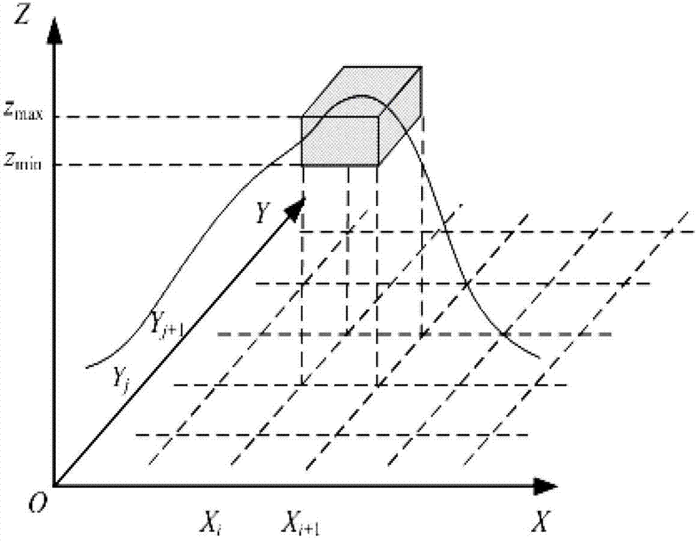
[0023] figure 1 This is the overall flow chart of the large-scale 3D terrain modeling method based on scanning lasers proposed in this patent. The terrain model used is a probabilistic elevation map (such as figure 2 shown). The specific steps of the algorithm are as follows:

[0024] 1. Acquisition and transformation of terrain data

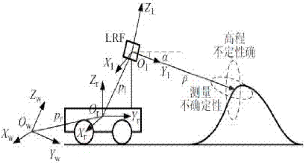
[0025] The collection of terrain data is the basis of terrain modeling. The surrounding terrain environment is scanned by a two-dimensional scanning laser installed on a mobile platform (such as a mobile robot platform) to obtain environmental perception data, and then according to the positioning sensor information (odometer and GPS) ) to perform fusion positioning on the mobile platform to obtain the global coordinates of its pose. On this basis, the original laser data is converted into a 3D point cloud b...


PUM


Abstract

The invention discloses a scanning laser based large-scale three-dimensional terrain modeling method. The scanning laser based large-scale three-dimensional terrain modeling method comprises the following steps of: firstly perceiving a surrounding environment through the scanning laser arranged on a mobile robot platform, and transforming original laser data into three-dimensional point clouds through coordinate transformation; secondly preprocessing the three-dimensional point clouds by adopting a median filter method, and constructing an octree structure to complete data storage; then carrying out fusion processing on data by adopting a Gaussian mixed model based randomization method to build a terrain environment model in real time; and finally detecting and processing an obstructed area positioned in the terrain environment model to further enhance model accuracy. In the invention, the problem of real-time modeling of a large-scale complex terrain is effectively solved by adopting the low-cost two-dimensional scanning laser; and good balance between the model accuracy and real-time property is realized in such a way that randomization processing is carried out on various uncertainties of the terrain environment model, and therefore, wide requirements of different fields, such as a GIS (Geographic Information System) system or unmanned autonomous navigation and the like, can be met.

Description

technical field [0001] The invention relates to a large-scale three-dimensional terrain modeling method based on scanning lasers, especially a probabilistic three-dimensional terrain modeling method based on a Gaussian mixture model, belonging to geographic information systems (GIS), autonomous navigation of unmanned platforms, and robots. technology and other fields. Background technique [0002] In application fields such as geographic information system (GIS), unmanned autonomous platform navigation, survey and scientific research, computer graphics, remote sensing, virtual reality, etc., an accurate real-time 3D terrain model plays a vital role and directly determines the overall System operating efficiency and overall economic benefits. Different from the indoor environment, the wild environment presents more diverse unstructured and uncertain characteristics, and the large-scale characteristics of the environment exacerbate the complexity of the problem, which brings ...

Claims


Application Information

Patent Timeline
Patent Type & Authority Applications(China)
IPC IPC(8): G06T17/05
Inventor 周波戴先中马旭东钱来
Owner SOUTHEAST UNIV
Why Eureka
Try Eureka