
Method and device for determining land surface emissivity of narrow band and broad band simultaneously

A specific emissivity and narrow-band technology, applied in the field of remote sensing quantitative inversion, can solve problems that hinder the estimation of surface wide-band specific emissivity

Inactive Publication Date: 2014-09-10
INST OF GEOGRAPHICAL SCI & NATURAL RESOURCE RES CAS
View PDF4 Cites 0 Cited by
  • Summary
  • Abstract
  • Description
  • Claims
  • Application Information

AI Technical Summary

Problems solved by technology

[0004] Due to the limitation of measuring instruments, the existing surface object spectrum library generally only measures the surface object spectrum below 14 μm, which hinders the estimation of the surface wide-band specific emissivity to a certain extent

Method used


Image

  • Method and device for determining land surface emissivity of narrow band and broad band simultaneously
  • Method and device for determining land surface emissivity of narrow band and broad band simultaneously
  • Method and device for determining land surface emissivity of narrow band and broad band simultaneously

Examples


specific Embodiment approach

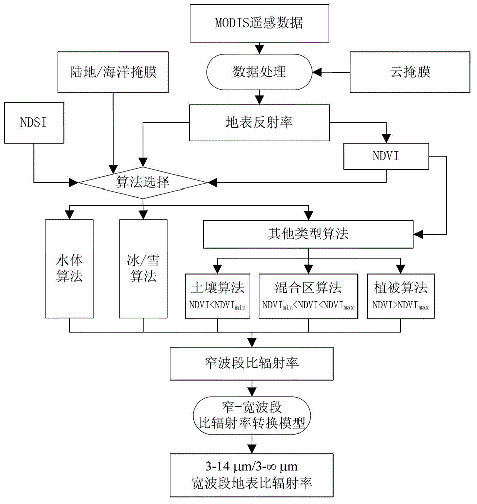
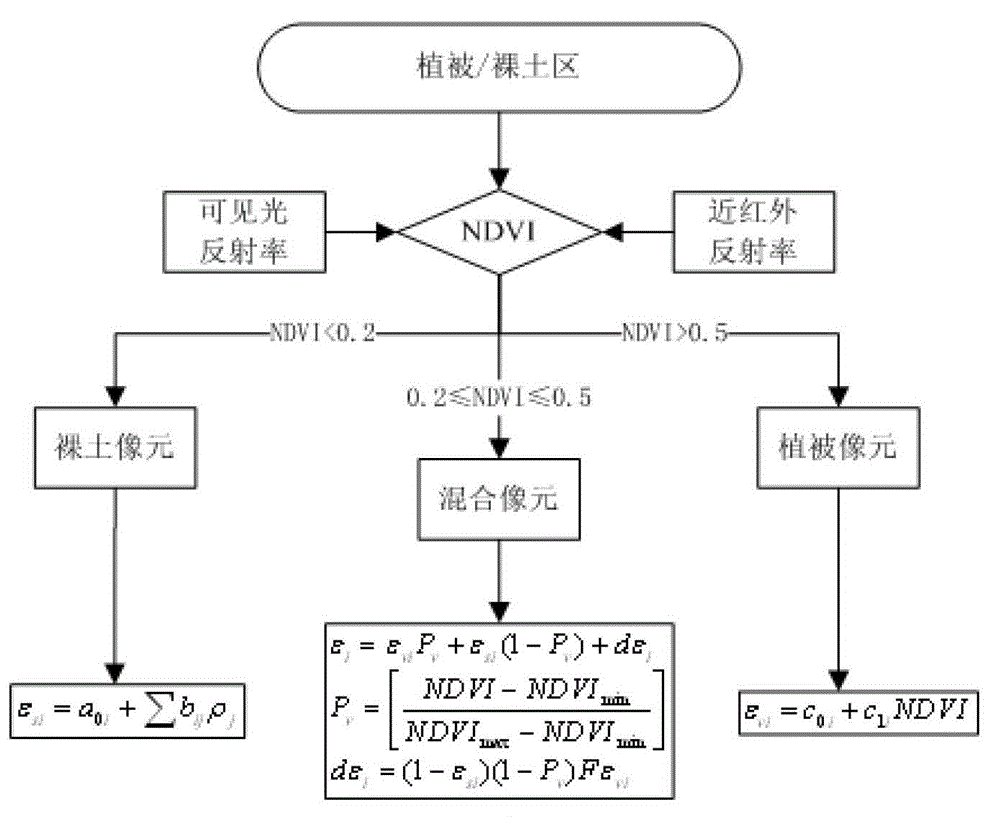
[0059] First, combining the land / ocean mask data in the MODIS data product MOD03, the pixels in the image are divided into three categories: ocean pixels, inland water body pixels and land pixels. The inland water and land cells in the imagery are then further subdivided. The specific classification method is: according to the calculated visible light / near-infrared surface reflectance data, calculate the normalized snow cover index (NDSI) and normalized normalized vegetation index (NDVI), and divide the inland water body pixel and land pixel It is further divided into five categories: inland water body pixel, snow / ice pixel, bare soil pixel, vegetation pixel, and vegetation / bare soil mixed pixel. The specific implementation is as follows:

[0060] Build a normalized difference snow index model (NDSI):

[0061] NDSI = ρ 4 - ρ ...


PUM


Abstract

The invention discloses a method and a device for determining the land surface emissivity of a narrow band and a broad band simultaneously. The method comprises the following steps of: A) performing data processing such as radiometric calibration, atmospheric correction and cloud mask processing on moderate resolution imaging spectroradiometer (MODIS) data to acquire land surface reflectance data of a visible light / near-infrared band of the MODIS data positioned at a 0.4-2.1 mu m atmospheric window area under the condition of a clear sky; B) determining the land surface emissivity of narrow bands such as a 29th wave band (the spectrum range is 8.4-8.7 mu m), a 31th wave band (the spectrum range is 10.78-11.28 mu m) and a 32th wave band (the spectrum range is 11.77-12.27 mu m) of an MODIS thermal infrared spectrum by using the reflectance data which is acquired in the step A and combining a developed narrow band emissivity inverse algorithm; and C) acquiring the land surface emissivity of broad bands of 3-14 mu m and 3 to infinite mu m by using the land surface emissivity of the narrow bands which is obtained in the step B and combining a developed narrow-broad band emissivity transformation model.

Description

technical field [0001] The invention belongs to the field of remote sensing quantitative inversion, in particular to a method and a device for simultaneously determining the surface specific emissivity of a narrow band and a wide band. Background technique [0002] Surface specific emissivity, as an inherent property of surface natural substances, is affected by factors such as land cover type, soil moisture, soil organic matter, vegetation density and structure, surface roughness, and surface relief. It can indicate the material composition of the surface, and it can be classified on the surface , Soil formation and erosion, estimation of sparse vegetation coverage and change, bedrock mapping and resource detection are all of great significance. In addition, the surface emissivity plays an important role in the inversion of surface temperature, and it is difficult to obtain accurate temperature inversion results without accurate emissivity. When the retrieval accuracy of t...

Claims


Application Information

Patent Timeline
Patent Type & Authority Patents(China)
IPC IPC(8): G01J3/42
Inventor 唐伯惠吴骅唐荣林
Owner INST OF GEOGRAPHICAL SCI & NATURAL RESOURCE RES CAS
Learn More