Gravity field or magnetic field data based geologic body three-dimensional visualized modeling and interpretation method

A technology of gravity field and geological body, applied in the field of three-dimensional visualization modeling of geological body, can solve problems such as not suitable for calculation and interpretation of large amount of data, poor practicability, and incapable of model fitting work

Inactive Publication Date: 2013-01-30
CHINA AERO GEOPHYSICAL SURVEY & REMOTE SENSING CENT FOR LAND & RESOURCES
View PDF4 Cites 20 Cited by
  • Summary
  • Abstract
  • Description
  • Claims
  • Application Information

AI Technical Summary

Problems solved by technology

[0006] First, the occurrence form of most orebodies in nature is a real three-dimensional geological body, and the regular three-dimensional geological body model and the two-degree half-body model cannot explain orebodies with complex structures
[0007] Second, although the traditional method has a certain three-dimensional operation function, it is not fine and deep enough
However, it has limitations and cannot fit the model through real-time forward calculation of the model
Moreover, the interactive operation mode of spatial edit

Method used


Image

  • Gravity field or magnetic field data based geologic body three-dimensional visualized modeling and interpretation method
  • Gravity field or magnetic field data based geologic body three-dimensional visualized modeling and interpretation method
  • Gravity field or magnetic field data based geologic body three-dimensional visualized modeling and interpretation method

Examples


Embodiment 1

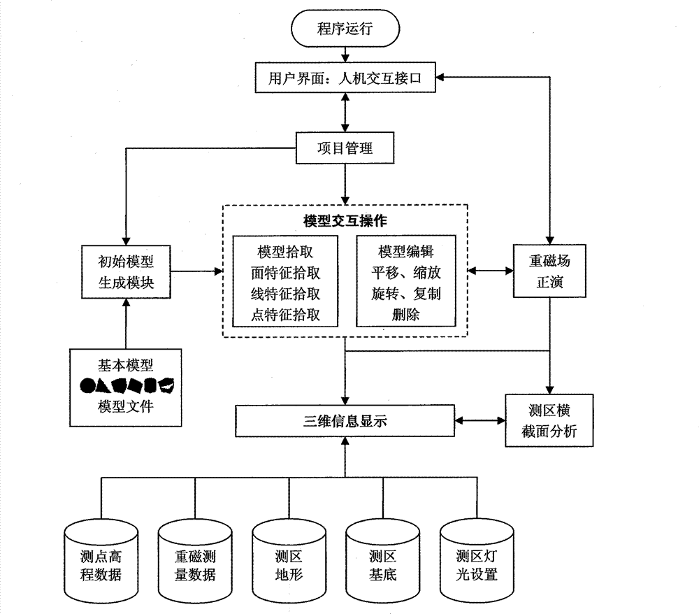
[0103] The specific implementation process of the 3D visualization modeling and interpretation method of geological bodies based on gravity field data is as follows:

[0104] (1) Read in the actual measurement data of the gravity field

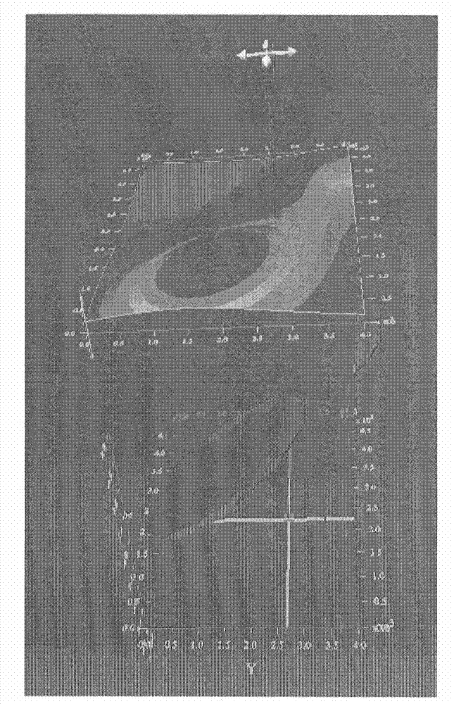
[0105] Input the ground elevation of each sampling point actually measured in the field, the aerial survey track, the base control point of the survey area, and the set original abnormal body model, input the coordinates and the strength of the gravity field of each sampling point actually measured in the field, and draw the gravity field 3D potential field, such as image 3The curved surface, that is, the measured field, and automatically sets the range of the measured area according to the read-in measured data.

[0106] (2) Interactive modeling of 3D geological bodies

[0107] Using the interactive model input and editing method provided by the software, first input the original abnormal body model of standard shape, such as spherical bod...

Embodiment 2

[0118] The specific implementation process of the 3D visualization modeling and interpretation method of geological bodies based on magnetic field data is as follows:

[0119] (1) Read in the actual measurement data of the magnetic field

[0120] Input the ground elevation of each sampling point actually measured in the field, the aerial survey trajectory, the base control point of the survey area, and the set original abnormal body model, input the coordinates and magnetic field strength of each sampling point actually measured in the field, and draw the three-dimensional position of the magnetic field field, such as image 3 The curved surface, that is, the measured field, and automatically sets the range of the measured area according to the read-in measured data.

[0121] (2) Interactive modeling of 3D geological bodies

[0122] Using the interactive model input and editing method provided by the software, first input the original abnormal body model of standard shape, s...

Embodiment 3

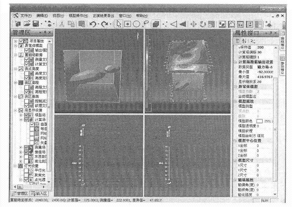
[0133] This embodiment is an explanation example of magnetic field data modeling. The magnetic field data in this embodiment comes from aeromagnetic surveys in a certain area. The data collection uses the HC07 type helium optical pump magnetometer, the DSC-1 type aeromagnetic automatic digital recorder, and the HD01 navigation system independently developed by the China Land and Resources Aviation Geophysical Prospecting and Remote Sensing Center. The aircraft uses the Y-12 four-type aircraft. In the field measurement, the HC07 type helium optical pump magnetometer is used to measure the local magnetic field strength, and the data is recorded and stored by the DSC-1 type aeromagnetic automatic digital recorder. Then the data in the instrument is recovered to the computer for processing.

[0134] After reading in the measured data, the system automatically sets the range of the measuring area and draws a three-dimensional surface map of the measured magnetic field data. Use ...


PUM


Abstract

The invention provides a gravity field or magnetic field data based geologic body three-dimensional visualized modeling and an interpretation method. Spatial characteristic and attributive analysis of a geologic body is completed by means of the three-dimensional forward fitting method and the interactive visualized technology; and various visualization schemes for anomalous body models, gravity field or magnetic field data curves and field axis sections are provided, models are integrally or locally subjected to translation, zooming, rotation, subdivision and the like by means of three-dimensional interaction, and functions of integral and local contrastive analysis, user-defined multimode display and the like of airborne geophysical prospecting data are realized.

Description

technical field [0001] The invention relates to the field of three-dimensional visualization modeling of geological bodies based on gravity field or magnetic field data, in particular to a three-dimensional visualization modeling and interpretation method of geological bodies based on gravity field or magnetic field data. Background technique [0002] Geophysical prospecting is an important means of geological prospecting. Through the processing, analysis and interpretation of geophysical prospecting data (gravity field and magnetic field data are two main types of geophysical prospecting data), it is possible to delineate the location of ore bodies and determine the occurrence and storage of ore bodies. The results of geophysical data analysis are generally reflected in the form of images. [0003] With the recent rapid development of 3D visualization technology hardware and software, 3D visualization technology has penetrated into all aspects of geophysical data processin...

Claims


Application Information

Patent Timeline
IPC IPC(8): G01V7/06G01V3/38G06T17/05
Inventor 熊盛青薛典军王林飞闫浩飞骆遥何辉田嵩董华
Owner CHINA AERO GEOPHYSICAL SURVEY & REMOTE SENSING CENT FOR LAND & RESOURCES
Why Eureka
Try Eureka