Method and device for manufacturing live-action map

A technology of real-scene maps and production methods, which is applied to the details of image stitching, maps/plans/charts, image enhancement, etc., which can solve problems such as inconvenient use for users, inability to modify, and label, etc., so as to improve user experience and realize updates and extended effects

Inactive Publication Date: 2013-02-06
ZTE CORP
View PDF5 Cites 41 Cited by
  • Summary
  • Abstract
  • Description
  • Claims
  • Application Information

AI Technical Summary

Problems solved by technology

[0003] The current live map mainly relies on satellite maps, such as: google street view map, or some professional website teams to produce, such as: city bar, etc. Generally, this kind of map needs to be paid for or connected to the Internet, and the map is pre-produced , only standard geographic information can be displayed, and users cannot modify or label it. These problems have caused inconvenience to users.

Method used


Image

  • Method and device for manufacturing live-action map
  • Method and device for manufacturing live-action map
  • Method and device for manufacturing live-action map

Examples


Embodiment Construction

[0052] The structure and principle of the present invention will be described in detail below in conjunction with the accompanying drawings, and the examples given are only used to explain the present invention, not to limit the protection scope of the present invention.

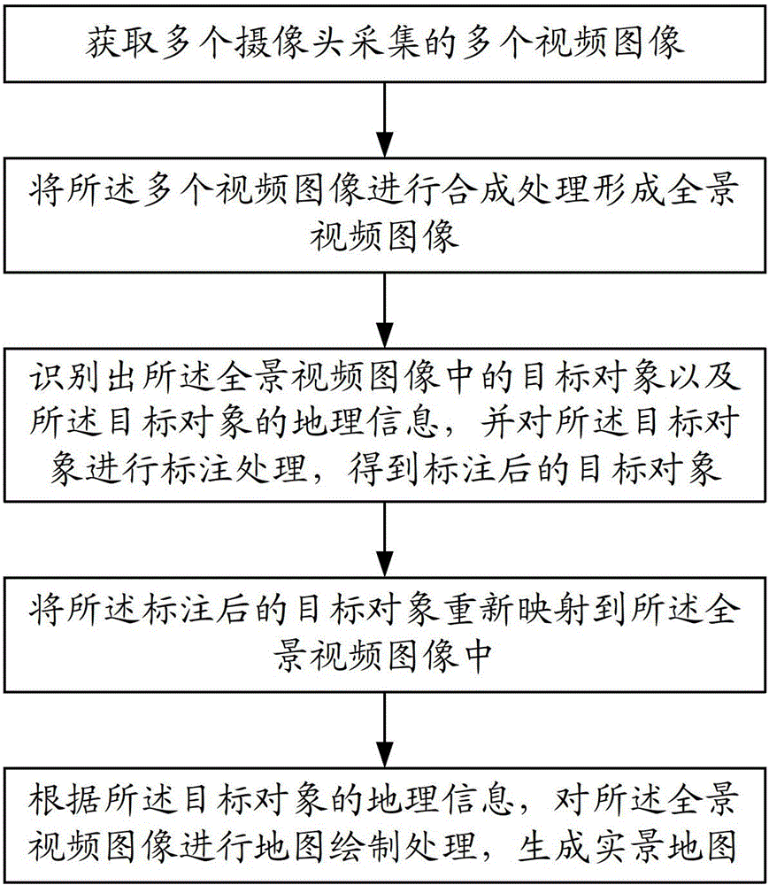
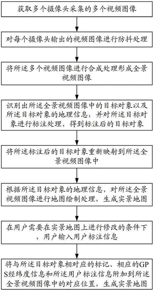
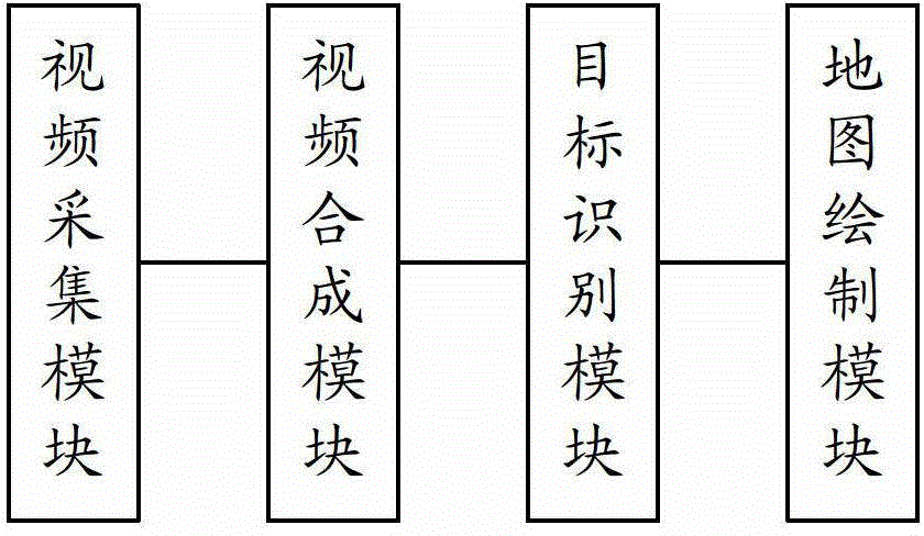
[0053] In order to break through the mode that the traditional real-scene map needs to be produced by a professional team, and users can only pay for it or use the map online, the present invention provides a method for making a real-scene map, such as figure 1 As shown, the making method of the real scene question map in the present embodiment comprises the following steps:

[0054] Obtain multiple video images collected by multiple cameras;

[0055] Synthesizing the plurality of video images to form a panoramic video image;

[0056] Identifying the target object in the panoramic video image and the geographic information of the target object, and labeling the target object to obtain the labeled target obj...


PUM


Abstract

The invention relates to a method and a device for manufacturing a live-action map. The method comprises the following steps: acquiring a plurality of video images acquired by a plurality of cameras; synthetizing and processing the plurality of video images to form a full-view video image; identifying a target object in the full-view video image and geographic information of the target object; marking the target object to acquire the marked target object; renewedly mapping the marked target object to the full-view video image; and performing map drawing processing on the full-view video image according to the geographic information of the target object and generating the live-action map. The method and the device have the beneficial effects that real-time manufacturing of the live-action map can be realized by a user, and a traditional mode that the live-action map needs to be manufactured by a special team and the user can use the map by only payment or internet is broken through; and by adopting the live-action map manufactured by the method and the device, the live-action map can be used free, and the dependence of internet loading on signals and geographical conditions can also be avoided.

Description

technical field [0001] The present invention relates to the fields of image processing and virtual reality, and more specifically to a method and device for making a real-scene map. Background technique [0002] Maps are an indispensable tool in people's life and work. With the development of transportation and the development of tourism, in order to obtain a better map experience, more and more people choose to use real-world maps. The real map is a very interesting map roaming mode. People can roam on the virtual city streets with a 360-degree perspective and watch the street scenes. Combining the superior position query ability of the electronic map with the virtual reality experience provided by the panorama , will provide great convenience to people's daily life and travel. [0003] The current live map mainly relies on satellite maps, such as: google street view map, or some professional website teams to produce, such as: city bar, etc. Generally, such maps need to be...

Claims


Application Information

Patent Timeline
Patent Type & Authority Applications(China)
IPC IPC(8): G09B29/00
CPCH04N7/18G06T17/05G09B29/00G06F17/30061G06F16/444G06T7/32G06T2200/32G06T2207/10016G09B29/005
Inventor 张丽晓尚浩强唐磊
Owner ZTE CORP
Why Eureka
Try Eureka