Method and system for detecting contour of urban building

A technology for contour detection and buildings, which is applied in the field of image processing, can solve problems such as the inability to accurately determine the boundaries of buildings, achieve large-scale rapid detection, avoid local extremum and iterative infinite loop problems, and achieve universal applicability

Inactive Publication Date: 2015-06-10
CHINA UNIV OF GEOSCIENCES (WUHAN)
View PDF3 Cites 0 Cited by
  • Summary
  • Abstract
  • Description
  • Claims
  • Application Information

AI Technical Summary

Problems solved by technology

[0005] The technical problem to be solved by the present invention is to provide a method and system for urban building outline detection that can accurately detect the boundaries of buildings in a wide range in view of the defects that the boundaries of buildings cannot be accurately determined in the prior art

Method used


Image

  • Method and system for detecting contour of urban building
  • Method and system for detecting contour of urban building
  • Method and system for detecting contour of urban building

Examples


Embodiment Construction

[0067] In order to make the object, technical solution and advantages of the present invention clearer, the present invention will be further described in detail below in conjunction with the accompanying drawings and embodiments. It should be understood that the specific embodiments described here are only used to explain the present invention, not to limit the present invention.

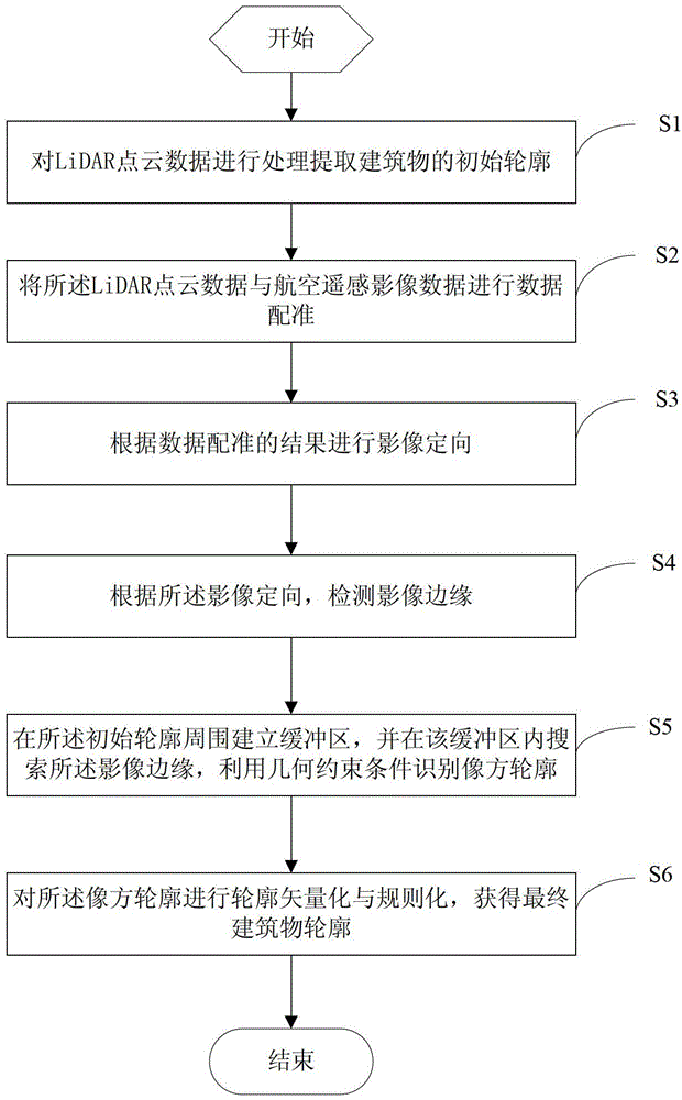
[0068] Such as figure 1 As shown, the method for urban building outline detection in the embodiment of the present invention comprises the following steps:

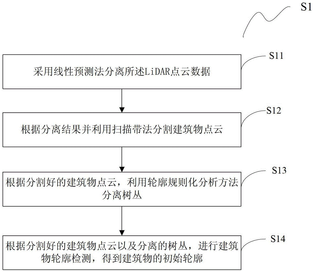
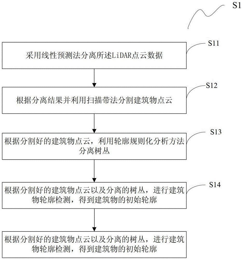
[0069] S1, processing the LiDAR point cloud data to extract the initial outline of the building;

[0070] S2. Data registration of LiDAR point cloud data and aerial remote sensing image data;

[0071] S3. Carry out image orientation according to the result of data registration;

[0072] S4. Detecting the edge of the image according to the orientation of the image;

[0073] S5. A buffer zone is established around the initial contour, and im...


PUM


Abstract

The invention discloses a method and a system for detecting a contour of an urban building. The method comprises the following steps of: S1, processing cloud data of a light detection and ranging (LiDAR) point, so as to extract an initial contour of the building; S2, performing data registering on the cloud data of the LiDAR point and aerospace remotely sensed image data; S3, performing image orientation according to a data registering result; S4, detecting an image edge according to the image orientation; S5, building a buffering region around the initial contour, searching the image edge in the buffering region, and identifying a contour of an image side by using a geometric constraint condition; and S6, performing contour vectorization and normalization on the contour of the image side to obtain the final contour of the building. By the method, the contours of a large range of urban buildings can be precisely detected.

Description

technical field [0001] The invention relates to the field of image processing, in particular to a method and system for detecting the contours of urban buildings. Background technique [0002] It is difficult to achieve high-quality and high-efficiency detection of urban building outlines simply by using remote sensing images, because: 1) Due to the complexity of the sensor imaging process of remote sensing satellites, building outlines are no longer ideal lines in the image, and their width, gray 2) The camera scale and image resolution of the sensor determine the geometric features of the building outline on the image; 3) Taller buildings tend to block the low buildings next to them , so that the information of its adjacent buildings is completely lost. Taller trees tend to blur the outline of the building on the image, or confuse it with other similar gray scale objects, especially causing road breaks during the outline recognition process; 4) Other targets on the roof s...

Claims


Application Information

Patent Timeline
Patent Type & Authority Patents(China)
IPC IPC(8): G06T7/00
Inventor 李卉钟成
Owner CHINA UNIV OF GEOSCIENCES (WUHAN)
Why Eureka
Try Eureka