Method and system for processing point cloud data

A point cloud data and processing method technology, applied in the field of surveying and mapping, can solve the problems of increasing data analysis and storage, fully automatic processing of point cloud troubles, and easy loss of detailed information, so as to reduce redundancy and improve accuracy.

Active Publication Date: 2013-02-27
BEIJING GENERAL RES INST OF MINING & METALLURGY
View PDF4 Cites 50 Cited by
  • Summary
  • Abstract
  • Description
  • Claims
  • Application Information

AI Technical Summary

Problems solved by technology

However, the existing algorithm is only applicable to scan line point cloud data, and if there are many noise points, the filter will judge them as non-noise points and not remove them
In this case, it is often necessary to rely on manual methods to remove noise points, which brings unnecessary troubles to field applications and fully automated point cloud processing
In addition, because the huge point cloud increases the burden of subsequent modeling, data analysis and storage, in order to solve this pro

Method used


Image

  • Method and system for processing point cloud data
  • Method and system for processing point cloud data
  • Method and system for processing point cloud data

Examples


Embodiment 1

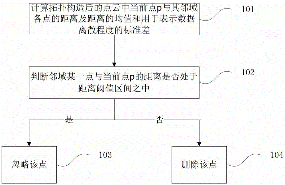
[0028] figure 1 A flow chart of a method for processing point cloud data provided by Embodiment 1 of the present invention mainly includes the following steps:

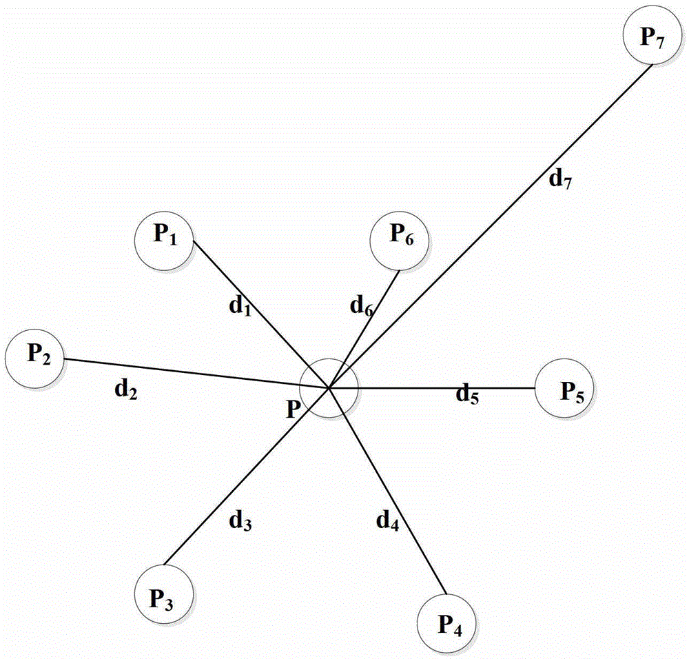
[0029] Step 101. Calculate the distance between the current point p and its neighboring points in the topologically constructed point cloud, the mean value μ of the distance, and the standard deviation σ used to represent the degree of data dispersion.

[0030] The point cloud data is the contour data of the measured object obtained by scanning the measured object with a 3D laser scanner. For example, use a 3D laser scanner to scan a vertical wall. In theory, if the wall is absolutely smooth, the scanned point cloud data should be on the same plane. However, due to the errors of the 3D laser scanner itself, the surface reflectivity of the measured object (generally determined by the material) and the suspended solid particles and other factors, the surface of the measured object's shape data will be attached to a num...

Embodiment 2

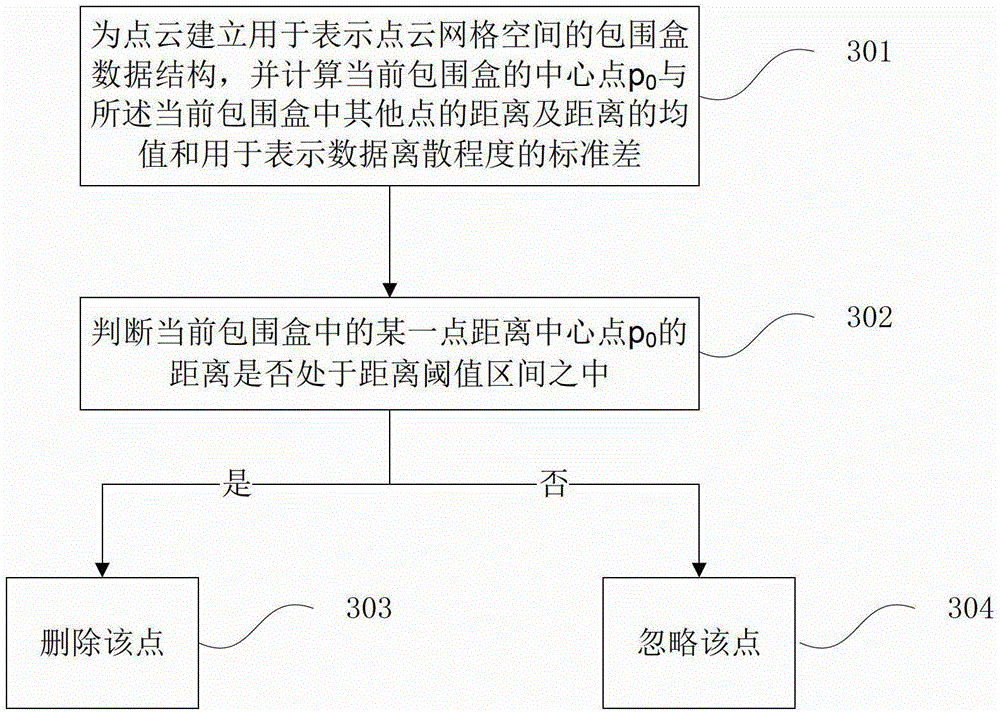
[0042] Embodiment 1 of the present invention introduces a method for removing neighborhood noise points according to a distance threshold, and this embodiment further processes point cloud data in combination with the method of Embodiment 1. Since the first four steps are consistent with the steps in Embodiment 1, they will not be described in detail. This embodiment only further introduces the subsequent steps, such as image 3 As shown, it mainly includes the following steps:

[0043] Step 301. Establish a bounding box data structure for the point cloud to represent the grid space of the point cloud, and calculate the center point p of the current bounding box 0 The distance from other points in the current bounding box and the mean value μ of the distance 0 and the standard deviation σ used to represent the degree of dispersion of the data 0 .

[0044] The point cloud data collected by the 3D laser scanner is more and more accurate than the data obtained by conventional ...

Embodiment 3

[0055] A processing system for point cloud data provided by an embodiment of the present invention, the system mainly includes:

[0056] The first calculation module 51 is used to calculate the distance between the current point p in the topologically constructed point cloud and its neighboring points and the mean value μ of the distance and the standard deviation σ used to represent the degree of data dispersion;

[0057] The noise point processing module 52 is used to judge whether the distance between a certain point in the neighborhood and the current point p is in the interval μ±α·σ, where α is the coefficient of the distance threshold; if so, ignore it; otherwise, delete the point;

[0058] Bounding box establishment module 53, is used for establishing the bounding box data structure that is used to represent point cloud grid space for point cloud;

[0059] The second calculation module 54 is used to calculate the center point p of the current bounding box 0 The distanc...


PUM


Abstract

The invention discloses a method and system for processing point cloud data. The method includes: calculating distance of a current point in point cloud after topology construction and neighborhood points, mean values mu of the distance and a standard deviation sigma for expressing data dispersion degree; judging whether the distance between one neighborhood point and the current point p is in an interval of mu+-alpha-sigma, if on yes judgment, neglecting, otherwise deleting the point; building a bounding box data structure used for expressing point cloud grid space for the point cloud, and calculating distance between a central point p0 of a current bounding box and other points in the current bounding box, a mean value mu0 of the distance and a standard deviation sigma0; judging whether the distance between one point in the current bounding box and the central point p0 is in an interval of mu0+-alpha0-sigma0, if on yes judgment, deleting the point, otherwise neglecting. The point cloud processing method improves accuracy of noise point filtration and precision of point cloud data and effectively reduces redundancy of the point cloud data.

Description

technical field [0001] The invention relates to the field of surveying and mapping, in particular to a method and system for processing point cloud data. Background technique [0002] During the data measurement process of the goaf 3D laser scanner, it is affected by factors such as the temperature in the environment, suspended solid particles, and the reflectivity of the goaf surface. The roughness of the surface, the reflection of holes and rock walls, and the system error of the 3D laser scanner itself make the collected data contain serious noise, which greatly interferes with the subsequent point cloud data processing. Therefore, before the 3D model reconstruction of the goaf, it is necessary to preprocess the measured point cloud data to obtain complete and correct measurement data to facilitate the subsequent 3D reconstruction work. In addition, the point cloud data obtained after preprocessing can also be registered, and deformation detection and analysis of gob sta...

Claims


Application Information

Patent Timeline
IPC IPC(8): G01B11/00G01B11/24
Inventor 刘冠洲陈凯张达杨小聪张晓朴韩志磊刘建东王治宇
Owner BEIJING GENERAL RES INST OF MINING & METALLURGY
Why Eureka
Try Eureka