Irregular-island-based method for planning covered flight route of unmanned aerial vehicle

A trajectory planning and irregular technology, applied in the field of UAV coverage trajectory planning based on irregular islands, can solve problems such as large amount of calculation, long planning time, local optimal solution, etc., and achieve the effect of meeting high requirements

Inactive Publication Date: 2013-03-20
北京中海新图科技有限公司 +1
View PDF10 Cites 39 Cited by
  • Summary
  • Abstract
  • Description
  • Claims
  • Application Information

AI Technical Summary

Problems solved by technology

However, there are common problems in traditional trajectory planning algorithms: easy to fall into local optimal solutions, large amount of calculation, long planning time, etc., which is contrary to the rapid maneuverability of UAVs
However, due to the uneven distribution of islands, which are particularly changeable, and include different distances such as offshore or far seas, the island-based UAV coverage trajectory planning is more different from the previous ordinary land planning methods, and even the trajectory planning method. The requirements are higher, and ordinary land-based UAV planning methods cannot meet their requirements
But now UAV track planning is still in the blank stage in the field of islands, and there is almost no special route planning method for islands, and the general land UAV route planning method does not fully consider the particularity of islands due to its limitations. Therefore, its planning method cannot be completely copied and applied to the route planning of island UAVs.

Method used


Image

  • Irregular-island-based method for planning covered flight route of unmanned aerial vehicle
  • Irregular-island-based method for planning covered flight route of unmanned aerial vehicle
  • Irregular-island-based method for planning covered flight route of unmanned aerial vehicle

Examples


Embodiment Construction

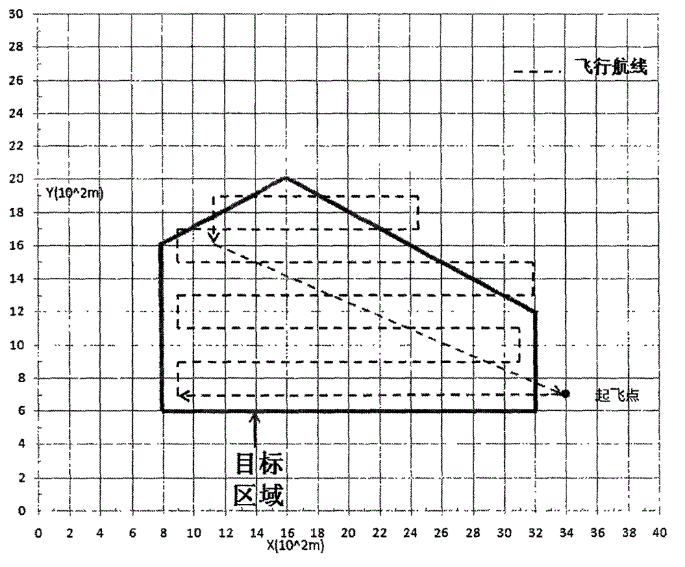
[0029] The UAV coverage route planning method based on irregular sea islands of the present invention comprises the following steps:

[0030] (1) Extract the circumscribed polygon of the irregular island;

[0031] (2) Calculate its minimum span according to the circumscribed polygon, and determine the flying direction of the UAV to reduce the number of turns;

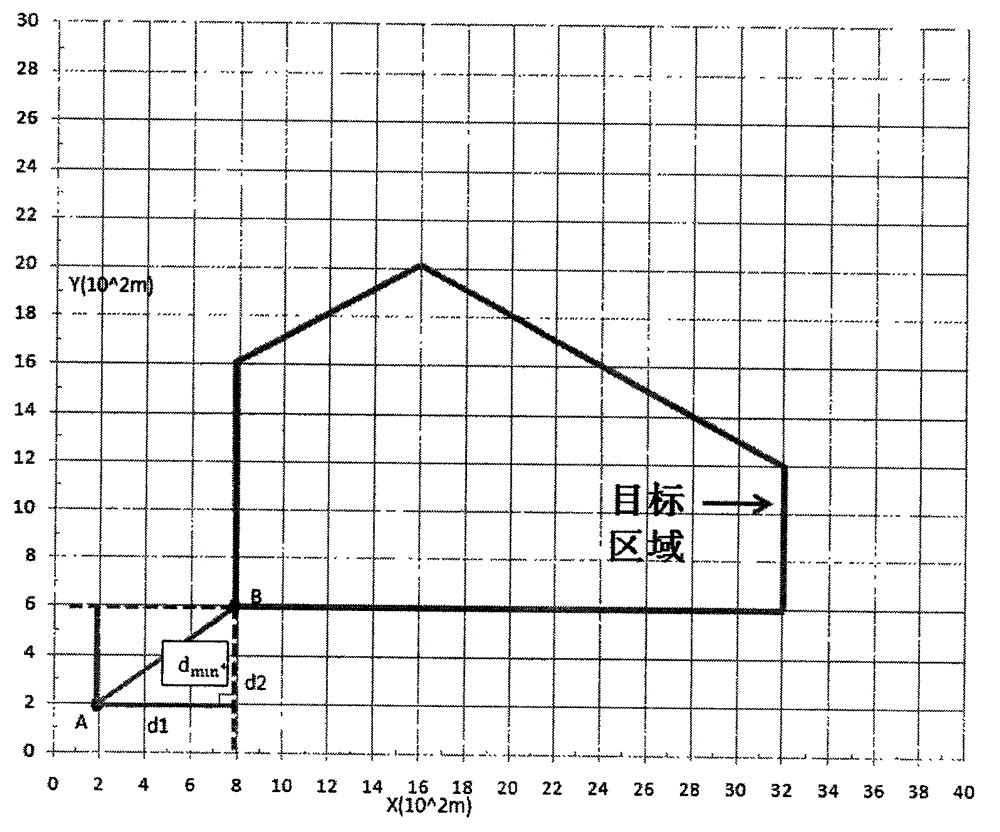
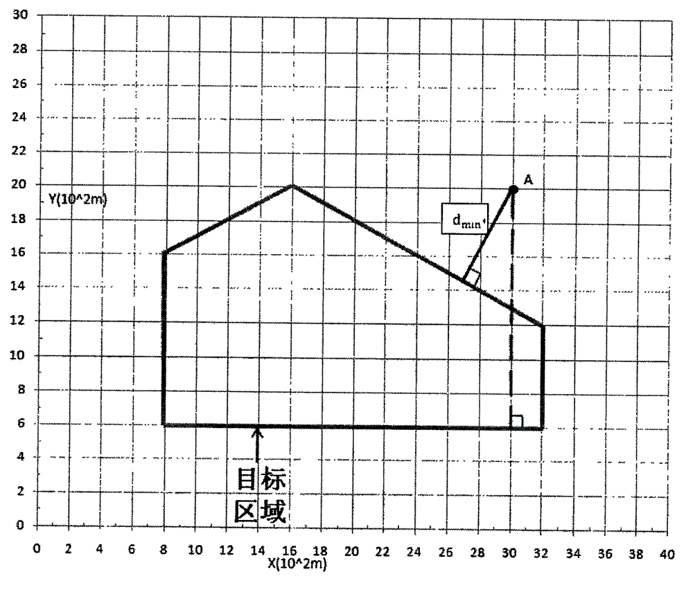
[0032] (3) Calculate the flight altitude according to the terrain conditions near the island, and determine the shortest distance from the take-off point to the circumscribed polygon of the island;

[0033] (4) Considering the number of turns, the minimum span of the polygon and the shortest distance from the takeoff point to the island to calculate the minimum route distance to obtain the optimal loop route.

[0034] 1. Selection of circumscribed polygons of irregular islands

[0035]Due to the irregular shape of most sea islands, for the wide application of this method, the present invention proposes a normalization...


PUM


Abstract

The invention provides an irregular-island-based method for planning a covered flight route of an unmanned aerial vehicle, aiming at the problem of planning an unmanned aerial vehicle flight route in an island domain. According to the method, the characteristics in island flight route traverse are sufficiently considered, i.e. the distance from a take-off point to an island is taken into consideration, particularly for an island which is relatively far away from the coast, the total journey in island flight route planning is influenced by the distance from the take-off point to the island to a large extent. in consideration of a geometric flight route programming method, the distance from the take-off point to the island and other related issues, the invention provides a new optimal circular flight route method and abandons the traditional impractical flight route planning method is abandoned; and situations such as the power of the aerial vehicle in flying are sufficiently considered in the new method. The method mainly comprises four aspects as follows: the extraction of the circumscribed polygon of the island, the calculation of the minimum span of the polygon, the calculation of the minimum distance from the take-off point to the polygon, and the design of the flight route. By utilizing the method, the combination of island monitoring and unmanned aerial vehicle flight route planning is realized, and the method particularly has a wide prospect on the aspect of offshore island monitoring.

Description

technical field [0001] The present invention relates to a track planning technology in the field of aerial photography of unmanned aerial vehicles, in particular to a method for planning a covered track of unmanned aerial vehicles based on irregular sea islands. Background technique [0002] Due to the advantages of portability, low cost, low loss, reusability, low risk, and wide application fields of UAVs, the application of UAVs has been widely developed in recent years. Since then, through the integration of UAV and remote sensing technology, UAV has become more automated and intelligent. Due to the characteristics of UAV, UAV remote sensing has the characteristics of high timeliness and high resolution, which further expands its application field. , Covering many aspects of military and civilian use, such as military reconnaissance and detection, early warning and civilian resource survey, environmental monitoring, meteorological observation and handling of emergencies, ...

Claims


Application Information

Patent Timeline
Patent Type & Authority Applications(China)
IPC IPC(8): G01C21/20
Inventor 于方杰马纯永田丰林韩勇陈戈吴合义王政杨乐
Owner 北京中海新图科技有限公司
Why Eureka
Try Eureka