Inertia/vision integrated navigation method for deep-space detection patrolling device

A technology for integrated navigation and deep space exploration, which can be applied in directions such as integrated navigators to solve problems such as poor safety and low accuracy

Active Publication Date: 2013-04-10
BEIHANG UNIV
View PDF8 Cites 39 Cited by
  • Summary
  • Abstract
  • Description
  • Claims
  • Application Information

AI Technical Summary

Problems solved by technology

[0005] The technical problem to be solved by the present invention is: to overcome the shortcomings of the traditional position estimation method combining inertial navigation and dead reckoning in the case of slipping, such as low precision and poor safety, and to make up for the movement in

Method used


Image

  • Inertia/vision integrated navigation method for deep-space detection patrolling device
  • Inertia/vision integrated navigation method for deep-space detection patrolling device
  • Inertia/vision integrated navigation method for deep-space detection patrolling device

Examples


Embodiment Construction

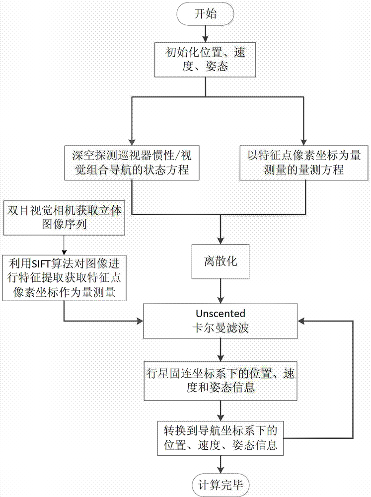
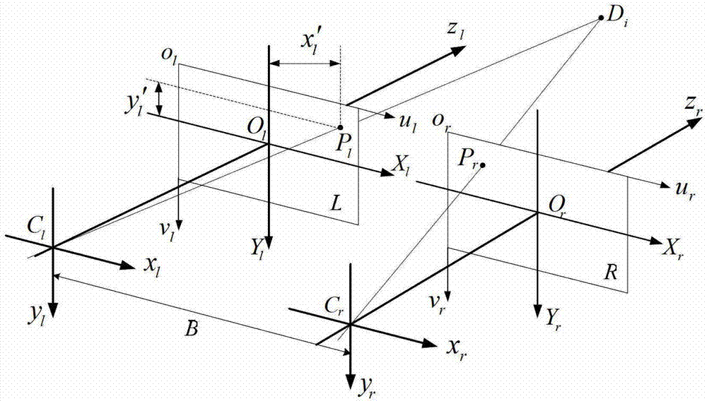
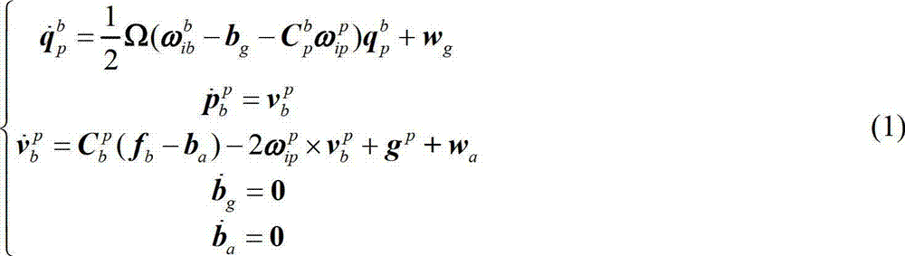
[0045] The patrol inertial / visual combined navigation method described in this embodiment involves many different coordinate systems and mutual transformations in both the state model and the measurement model. The coordinate systems are defined as follows:

[0046] ① Inertial coordinate system (o p x i the y i z i ): its origin is at the center of mass of the planet, z i axis perpendicular to the equatorial plane points to the North Pole, x i The axis points in the direction of the vernal equinox in the equatorial plane, y i axis and x i ,z i The axes form a right-handed orthogonal coordinate system.

[0047] ② Planetary fixed coordinate system (o p x p the y p z p ): its origin and z p The axis points to the same as the inertial coordinate system, x p axis points to the prime meridian in the equatorial plane, y p axis and x p ,z p The axes form a right-handed orthogonal coordinate system.

[0048] ③Planetary geodetic coordinate system (L, λ, h): The coordina...


PUM


Abstract

The invention relates to an inertia/vision integrated navigation method for a deep-space detection patrolling device. The method comprises the steps that a state model of inertia/vision integrated navigation of the patrolling device is established according to a serial inertial navigation mechanical arrangement in a fixed coordinate system of a planet; a binocular vision camera is used for shooting a surrounding environment of the patrolling device; a stereoimage sequence is obtained; pixel coordinates of characteristic points are obtained by an image characteristic extraction algorithm; a measurement model by taking the pixel coordinates of the characteristic points as measurement vectors is established; and a position, a speed and a state of the deep-space detection patrolling device are estimated by using Unscented kalman filter. The method can effectively correct a position error of inertial navigation and improve the navigation accuracy, is very applicable to autonomous navigation of the deep-space detection patrolling device, belongs to the technical field of space navigation, can provide high-precision navigational parameters for the deep-space detection patrolling device, and can provide references for the design of an autonomous navigation system of the deep-space detection patrolling device.

Description

technical field [0001] The invention relates to an inertial / visual combined navigation method based on pixel coordinate information of image feature points when a deep-space exploration patrol device patrols and surveys a planetary surface, and is an autonomous navigation method very suitable for a deep-space detection patrol device. Background technique [0002] As an important field of human spaceflight activities, deep space exploration has a special effect on a country's scientific research, economic development and military application value that cannot be compared with general spaceflight activities. As the main tool for current interplanetary exploration, the deep space exploration rover plays an important role in automatic patrol survey, image acquisition, sampling analysis and return of the planetary surface, and is one of the current research hotspots. [0003] The rover needs to drive and work safely in the unfamiliar unstructured environment on the surface of the...

Claims


Application Information

Patent Timeline
IPC IPC(8): G01C21/24
Inventor 宁晓琳白鑫贝房建成
Owner BEIHANG UNIV
Why Eureka
Try Eureka