Supercharge Your Innovation With Domain-Expert AI Agents!

Two-dimensional point-spread function processing method of meteorological satellite optical remote sensor

A technology of optical remote sensors and meteorological satellites, which is applied in the directions of instruments, climate sustainability, and re-radiation of electromagnetic waves, and can solve problems such as discontinuous spatial distribution

Inactive Publication Date: 2014-11-12
NAT SATELLITE METEOROLOGICAL CENT
View PDF4 Cites 0 Cited by
  • Summary
  • Abstract
  • Description
  • Claims
  • Application Information

AI Technical Summary

Problems solved by technology

For this reason, the present invention will propose a new two-dimensional PSF construction method to solve the problem of discontinuous spatial distribution caused by simple vector multiplication to construct two-dimensional PSF, and lay the foundation for the quantitative application of meteorological satellite observations

Method used


Image

  • Two-dimensional point-spread function processing method of meteorological satellite optical remote sensor
  • Two-dimensional point-spread function processing method of meteorological satellite optical remote sensor
  • Two-dimensional point-spread function processing method of meteorological satellite optical remote sensor

Examples


Embodiment Construction

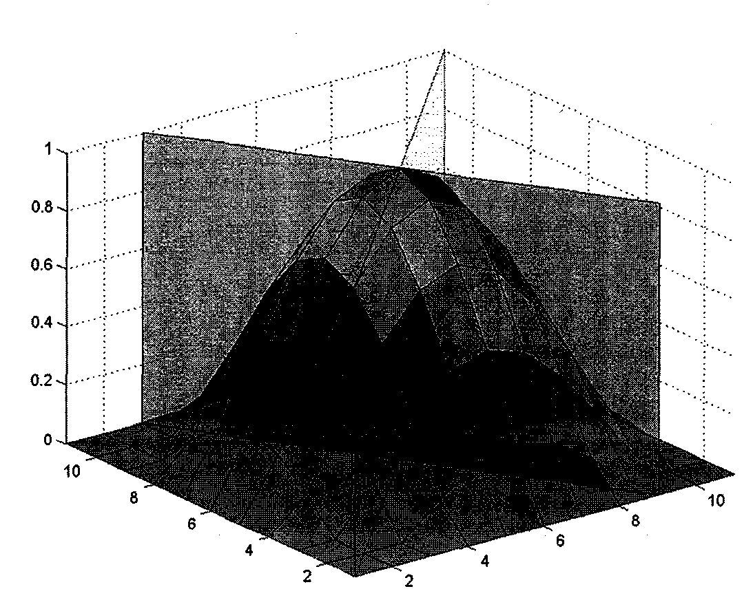
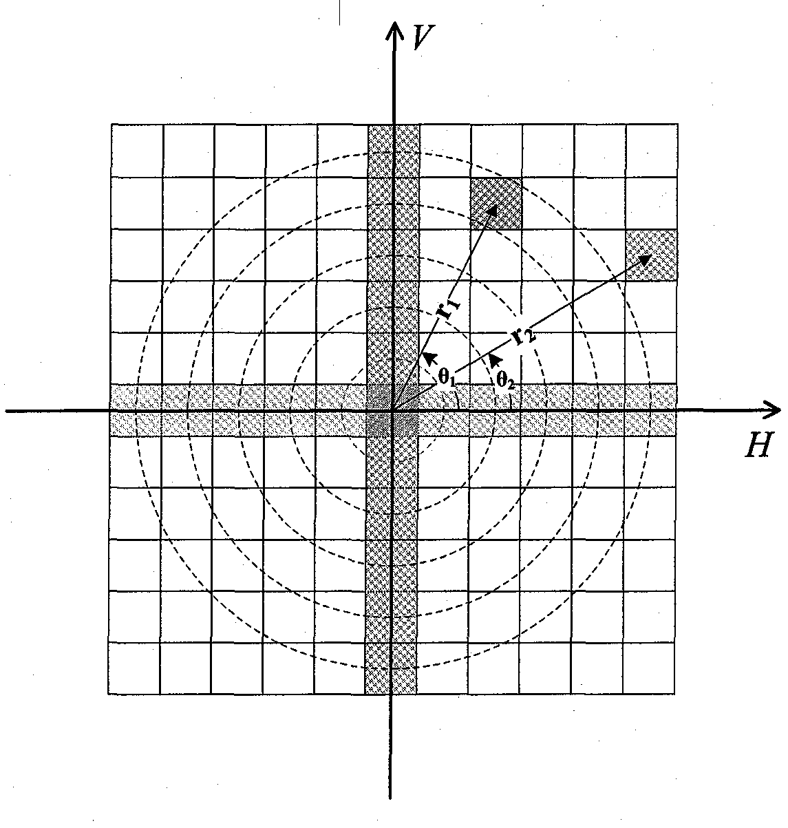
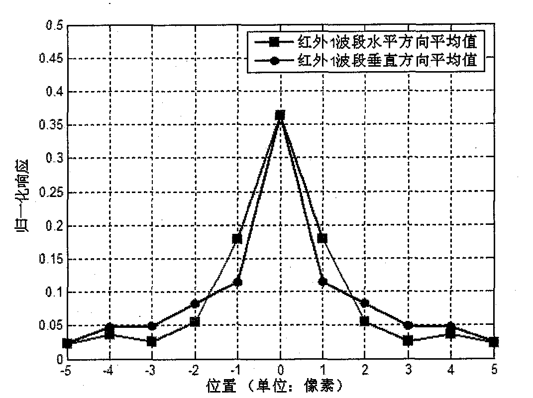
[0036] The core content of the present invention is exactly, utilize the one-dimensional PSF evaluation result of the meteorological satellite optical remote sensor that can obtain in two mutually perpendicular directions by using existing method, in the polar coordinate system newly established, respectively along polar angle and polar axis direction Two one-dimensional nested interpolation is performed to obtain a spatially continuous and smooth two-dimensional PSF processing result. For specific implementation steps, refer to the description in the Summary of the Invention.

[0037] In addition, in combination with the relatively slowly changing characteristics of the PSF function of the meteorological satellite optical remote sensor on the spatial distribution, the interpolation function in the present invention is recommended to optimize the Akima non-equidistant interpolation method, which is briefly described as follows:

[0038] Set the given n equidistant / non-equidist...


PUM


Abstract

The invention relates to a two-dimensional point-spread function (PSF) processing method of meteorological satellite optical remote sensor, and belongs to the meteorological technical field. In a newly-defined polar coordinate system, two known one-dimensional PSFs on two vertical directions are utilized, and a two-dimensional PSF distribution of the optical remote sensor can be obtained according to a one-dimensional interpolation nested along the polar angle and the polar axis directions. On the premise that PSF information on the known directions is not lost, PSF estimated results which are continuously and smoothly distributed in space are obtained. After restoration processing, information of observed objects with clear image quality can be obtained, and therefore accuracy of meteorological application is further improved.

Description

technical field [0001] The invention relates to a processing method for a two-dimensional point spread function of an optical remote sensor of a meteorological satellite, and belongs to the technical field of meteorology. Background technique [0002] Under the current background of global climate change and frequent occurrence of disastrous extreme weather events, how to make full use of spaceborne observations, especially the high-quality observation data of optical remote sensors carried by meteorological satellites, is the key to realizing short-term weather forecasts, medium- and short-term climate It is one of the important observation guarantees for meteorological disaster prevention and mitigation, such as weather forecasting, and it is increasingly exerting huge social and economic benefits. Meteorological satellites are the core of space-based meteorological observation methods and an important part of the comprehensive observation system of meteorological elements...

Claims


Application Information

Patent Timeline
Patent Type & Authority Patents(China)
IPC IPC(8): G01S7/48G01S17/95
CPCY02A90/10
Inventor 郭强
Owner NAT SATELLITE METEOROLOGICAL CENT
Features
  • R&D
  • Intellectual Property
  • Life Sciences
  • Materials
  • Tech Scout
  • Unparalleled Data Quality
  • Higher Quality Content
  • 60% Fewer Hallucinations
Learn More