GNSS/MINS (global navigation satellite system/micro-electro-mechanical systems inertial navigation system) super-deep combination navigation method, system and device

A deep integrated navigation and integrated navigation technology, applied in the field of GNSS/MINS ultra-deep integrated navigation methods, systems and devices, can solve the problems of nonlinear growth of phase detection error, degradation of tracking and positioning performance, and unsuitable tracking of vector loops.

Active Publication Date: 2013-08-07
TSINGHUA UNIV
View PDF2 Cites 30 Cited by
  • Summary
  • Abstract
  • Description
  • Claims
  • Application Information

AI Technical Summary

Problems solved by technology

[0007] Although the vector loop couples multiple channel information for tracking and positioning, its tracking sensitivity is better than that of the scalar loop, but the phase detector used in the vector loop is a nonlinear pha...

Method used


Image

  • GNSS/MINS (global navigation satellite system/micro-electro-mechanical systems inertial navigation system) super-deep combination navigation method, system and device
  • GNSS/MINS (global navigation satellite system/micro-electro-mechanical systems inertial navigation system) super-deep combination navigation method, system and device
  • GNSS/MINS (global navigation satellite system/micro-electro-mechanical systems inertial navigation system) super-deep combination navigation method, system and device

Examples


Embodiment 1

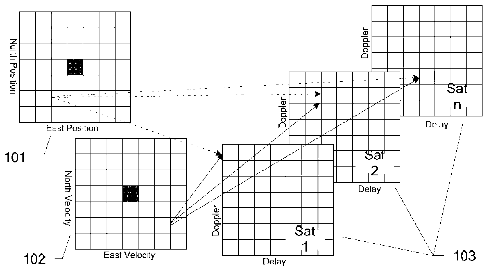
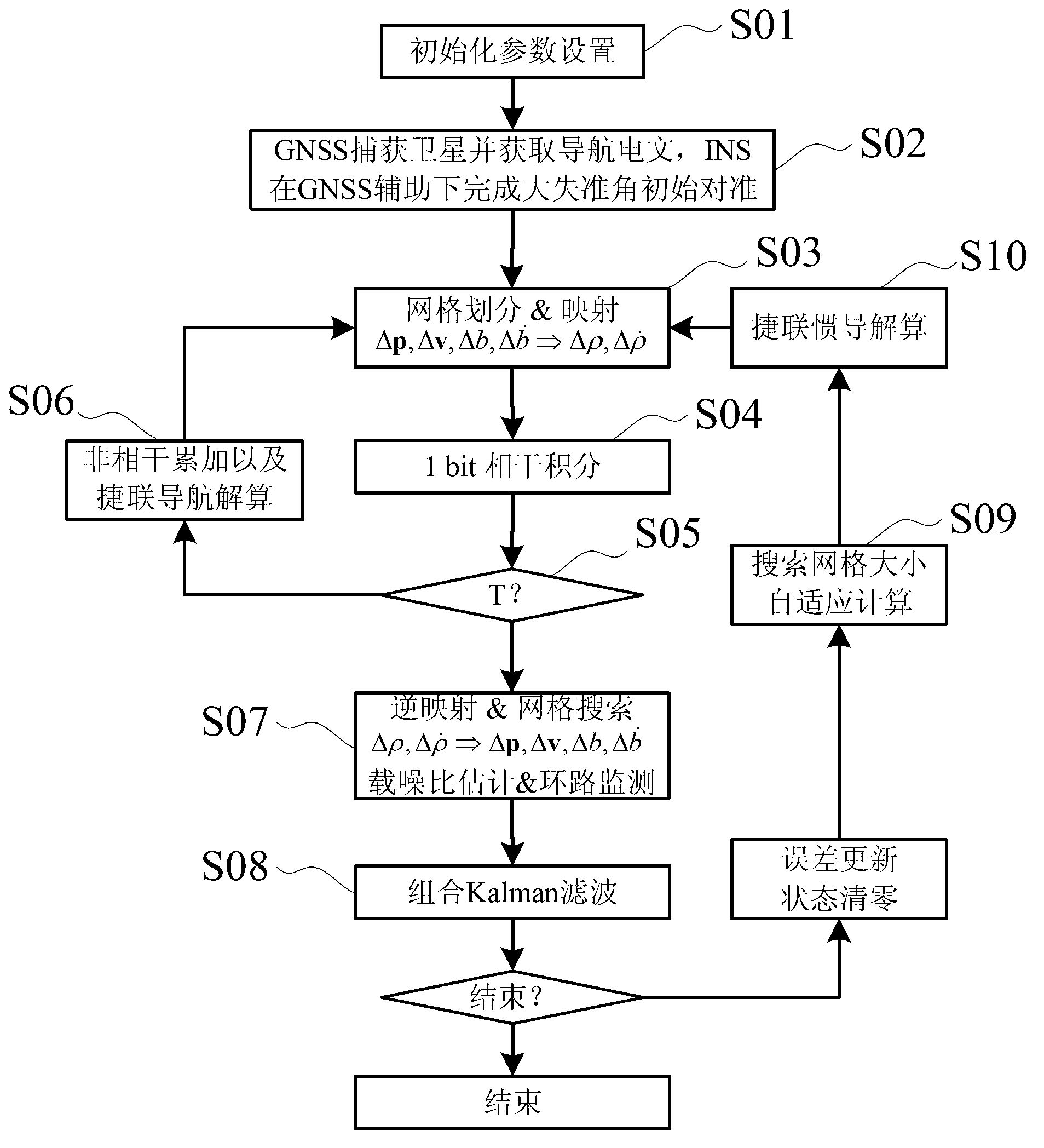
[0090] The essence and goal of any satellite positioning system is to determine the user's position and velocity. Based on this common point, the present invention proposes a positioning field concept based on position and velocity levels. Based on this concept, INS and GNSS can be combined at an ultra-deep level: using the position and speed assistance information provided by INS, GNSS uses the direct position estimation (DPE) algorithm to estimate position error, speed error, and clock error, thereby closing the loop . Because the system directly uses MIMU and baseband correlator as sensors, all navigation functions are realized in the top-level combination algorithm, that is, the algorithm uses GNSS baseband correlator as a sensor of sensitive space-time positioning field, and MIMU as a sensor of sensitive inertial field to realize It realizes the complete integration of GNSS and MINS. With the assistance of INS, GNSS combines multi-channel information for vector phase det...

Embodiment 2

[0172] like Image 6 Shown is the system architecture diagram of this embodiment. The GNSS / MINS ultra-deep integrated navigation system is mainly composed of a GNSS system, a MINS system and a correlator group 606 .

[0173] Among them, the GNSS system receives satellite signals through the antenna 601, and outputs the intermediate frequency signal after down-converting and sampling the satellite signals through the RF front-end 602, and receives satellite navigation messages; the MINS system obtains measurement data through the MIMU603, and passes through the strapdown inertial navigation system 604 After solving, the position, velocity and attitude of the carrier are obtained.

[0174] The system also includes:

[0175] The carrier frequency and code phase calculation unit 605 is used to combine the speed and position output by the MINS system with the satellite navigation message to calculate the GNSS signal carrier frequency and code phase to generate local signals;

[017...

Embodiment 3

[0184] This embodiment proposes a device applied to the method of Embodiment 1, such as Figure 7 shown.

[0185] The GNSS / MINS integrated navigation device includes: antenna 701 and radio frequency module 702, which introduces GNSS intermediate frequency data into the system through the interface of FPGA706; barometric altimeter 703, which introduces the barometric altitude data into the system through the interface of FPGA706; MIMU704, through the interface of FPGA706 The measurement data of MIMU704) is introduced into the system; and the power supply module 705, DSP708 and host computer 707.

[0186] Wherein, the integrated navigation device also includes a correlator group 709, the DSP708 will calculate the code phase, carrier frequency and projection vector, and write it into the FPGA706 through the EMIF bus, and the FPGA706 automatically divides the grid according to the size of the search grid and maps it to The correlator group 709, after the pre-detection integration...


PUM


Abstract

The invention provides a GNSS/MINS (global navigation satellite system/micro-electro-mechanical systems inertial navigation system) super-deep combination navigation method, aiming to realize super-deep combination of a GNSS and an MINS. The GNSS uses a direct location estimation method to estimate location errors, speed error and clock errors according to location and speed auxiliary information provided by an INS (inertial navigation system) to close loops; a system takes an MIMU (MINS inertial measurement unit) and a base band correlator as sensors to realize all the navigation functions in a top combinational algorithm, in other words, the algorithm takes the GNSS base band correlator as the sensor of sensitive space-time locating fields and takes the MIMU as the sensor of sensitive inertance fields to realize integral combination of the GNSS and the MINS; and by the aid of the INS, the GNSS combines multichannel information to perform vector phase discrimination and vector locating. The invention further provides super-deep combination system and device applied to the method. The method, the system and the device have the advantages of high navigation accuracy, good dynamic property, high GNSS tracking sensitivity, high GNSS anti-interference performance, wide GNSS dynamic pulling range and the like; and in theory, the dynamic range is limited by trends of the MINS, and -160dBM (decibels above one milliwatt in 600 ohms) signal tracking can be realized by the GNSS by the aid of the MINS.

Description

technical field [0001] The invention belongs to the technical field of integrated navigation, and in particular relates to a GNSS / MINS ultra-deep integrated navigation method, system and device. Background technique [0002] GNSS / MINS (Global Navigation Satellite System / Micro-Electro-Mechanical Systems Inertial Navigation System) integrated navigation system refers to the use of MIMU (MEMS Inertial Measurement Unit) as a sensor, composed of The GNSS receiver outputs position / velocity and other reference information to correct the MINS error, and the MINS output position / velocity assists the GNSS receiver to capture and track the navigation system. [0003] GNSS / MINS integrated navigation system has a good prospect in future aviation and vehicle applications because of its low cost, small size, no error accumulation over time, high sensitivity, and high dynamic stress resistance. At present, there are three types of integrated navigation algorithms: loose combination, tight ...

Claims


Application Information

Patent Timeline
IPC IPC(8): G01S19/49
Inventor 郭美凤刘刚张嵘崔晓伟包超
Owner TSINGHUA UNIV
Why Eureka
Try Eureka