Double-antenna GNSS/INS deeply integrated navigation method and device

A deep integrated navigation, dual-antenna technology, applied in the field of satellite mobile communications, can solve problems such as long alignment time, poor MIMU accuracy, and divergence

Inactive Publication Date: 2013-08-14
TSINGHUA UNIV
View PDF4 Cites 49 Cited by
  • Summary
  • Abstract
  • Description
  • Claims
  • Application Information

AI Technical Summary

Problems solved by technology

[0004] Due to the poor accuracy of MIMU, it is impossible to achieve initial alignment through sensitive earth rotation, so the GNSS receiver is used to output position/velocity information to assist alignment. Causes alignment not to be achieved or takes too long
[0005] On the other hand, due to the poor observability of the attitude of the integrated navigation system, the attitude angle will diverge when the carrier does not maneuver for a long time. Algorithm, the attitude angle will diverge
[0006] Patent CN20149750

Method used


Image

  • Double-antenna GNSS/INS deeply integrated navigation method and device
  • Double-antenna GNSS/INS deeply integrated navigation method and device
  • Double-antenna GNSS/INS deeply integrated navigation method and device

Examples


Embodiment Construction

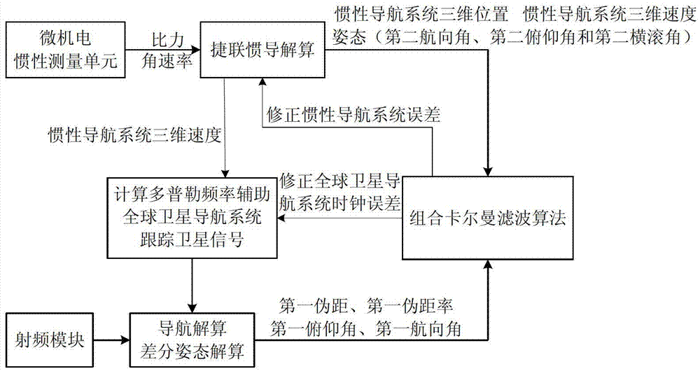
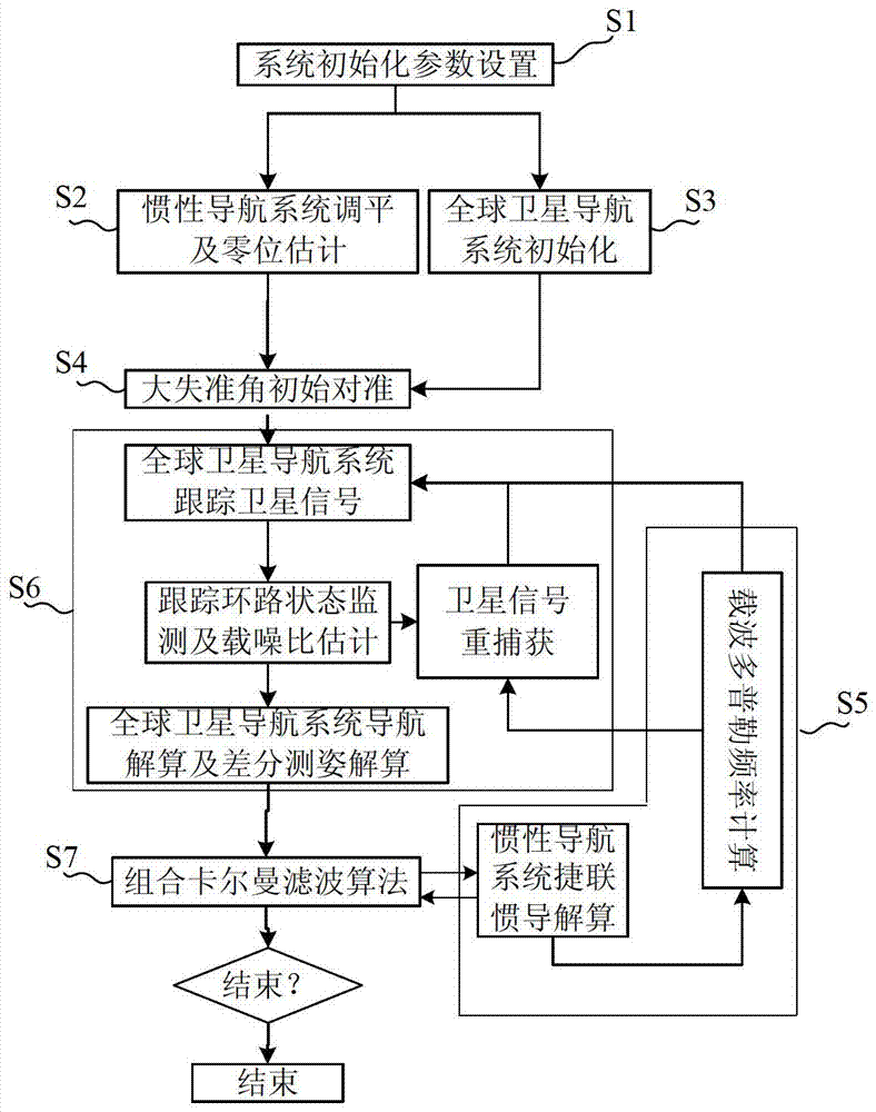
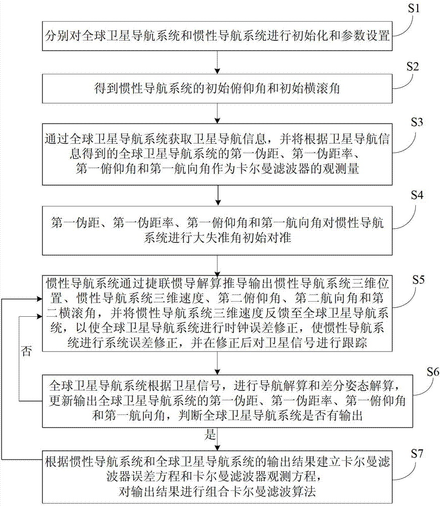
[0045] Embodiments of the present invention are described in detail below, examples of which are shown in the drawings, wherein the same or similar reference numerals designate the same or similar elements or elements having the same or similar functions throughout. The embodiments described below by referring to the figures are exemplary and are intended to explain the present invention and should not be construed as limiting the present invention.

[0046] In describing the present invention, it should be understood that the terms "center", "longitudinal", "transverse", "length", "width", "thickness", "upper", "lower", "front", " Orientation or position indicated by "back", "left", "right", "vertical", "horizontal", "top", "bottom", "inner", "outer", "clockwise", "counterclockwise", etc. The relationship is based on the orientation or positional relationship shown in the drawings, and is only for the convenience of describing the present invention and simplifying the descrip...


PUM

PropertyMeasurementUnit
Lengthaaaaaaaaaa

Abstract

The invention provides a double-antenna GNSS (Global Navigation Satellite System)/INS (Inertial Navigation System) deeply integrated navigation method and device. The device comprises a power supply module, an MEMS (Micro Electro Mechanical System) inertial measurement unit, a radio frequency module, an FPGA (Field Programmable Gate Array) module, a DSP (Digital Signal Processor) module and at least two antennas. According to the device, with the assistance of an INS, the probability of cycle slip of the GNSS can be reduced effectively, the integer ambiguity searching space of the GNSS is reduced, attitude measurement information is guaranteed to be continuously outputted, and the tracking loop robustness of the GNSS is enhanced; and with the assistance of a double-antenna GNSS, quick initial alignment of the INS can be realized, the attitude observability of the INS is improved, and the attitude divergence of the INS is inhibited.

Description

technical field [0001] The invention belongs to the technical field of satellite mobile communication, and in particular relates to a dual-antenna GNSS / INS deep integrated navigation method and device. Background technique [0002] INS (Inertial Navigation System, inertial navigation system) has the characteristics of autonomy, strong anti-interference and good concealment, and can continuously output navigation parameters such as position, speed, and attitude at high speed. time work requirements. GNSS (Global Navigation Satellite System, global satellite navigation system) can output position, speed, and time information with high precision around the world and around the clock. The navigation results do not accumulate over time, but the update rate of navigation data is generally less than 20Hz, and in high dynamic or strong interference environments The satellite signal will be lost and the navigation will not work. It can be seen that INS and GNSS have complementary a...

Claims


Application Information

Patent Timeline
IPC IPC(8): G01S19/49
Inventor 郭美凤刘刚张嵘包超
Owner TSINGHUA UNIV
Why Eureka
Try Eureka