Method for geography phenomenon multi-point simulation spatial scale selection

A space-scale, multi-point simulation technology, applied in the field of spatial information, to improve simulation efficiency and avoid uncertainty

Inactive Publication Date: 2013-08-28
SHANXI UNIV +1
View PDF4 Cites 6 Cited by
  • Summary
  • Abstract
  • Description
  • Claims
  • Application Information

AI Technical Summary

Problems solved by technology

But Goodchild pointed out that this method does not give a specific indicator to reflect the degree of spatial correlation like Moran’s I and other continuous value variables, but only gives a judgment whether it is related

Method used


Image

  • Method for geography phenomenon multi-point simulation spatial scale selection
  • Method for geography phenomenon multi-point simulation spatial scale selection
  • Method for geography phenomenon multi-point simulation spatial scale selection

Examples


Embodiment 1

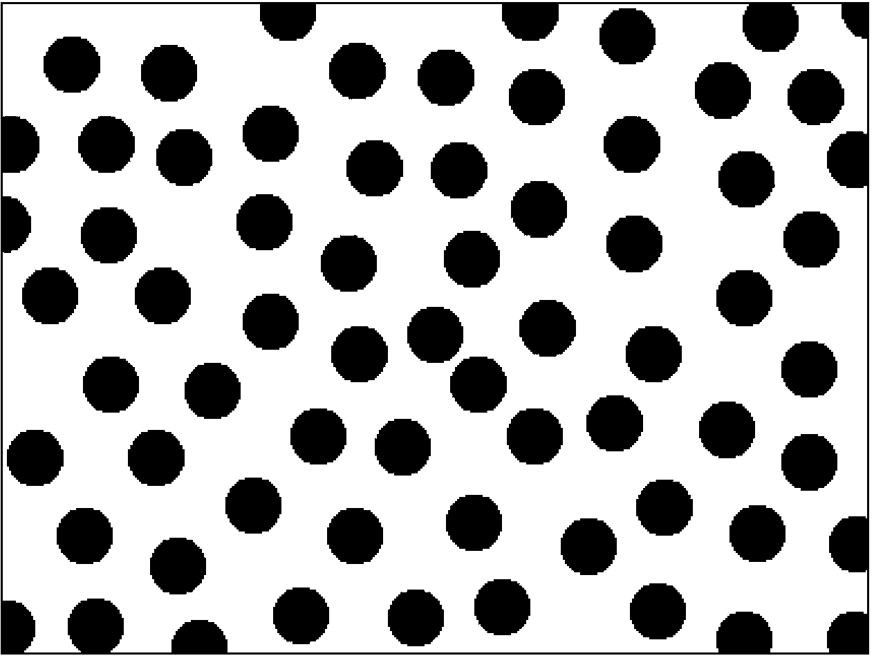
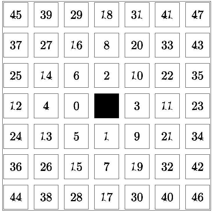
[0044] The first example simulates typical isotropic ground objects. The target ground objects used here are assumed to be circular. Here, the two types of ground objects are simply named white and black ground objects according to their colors. figure 2 is the training image required for multi-point simulation, the size is 400×300, image 3 It is a template required for multipoint simulation.

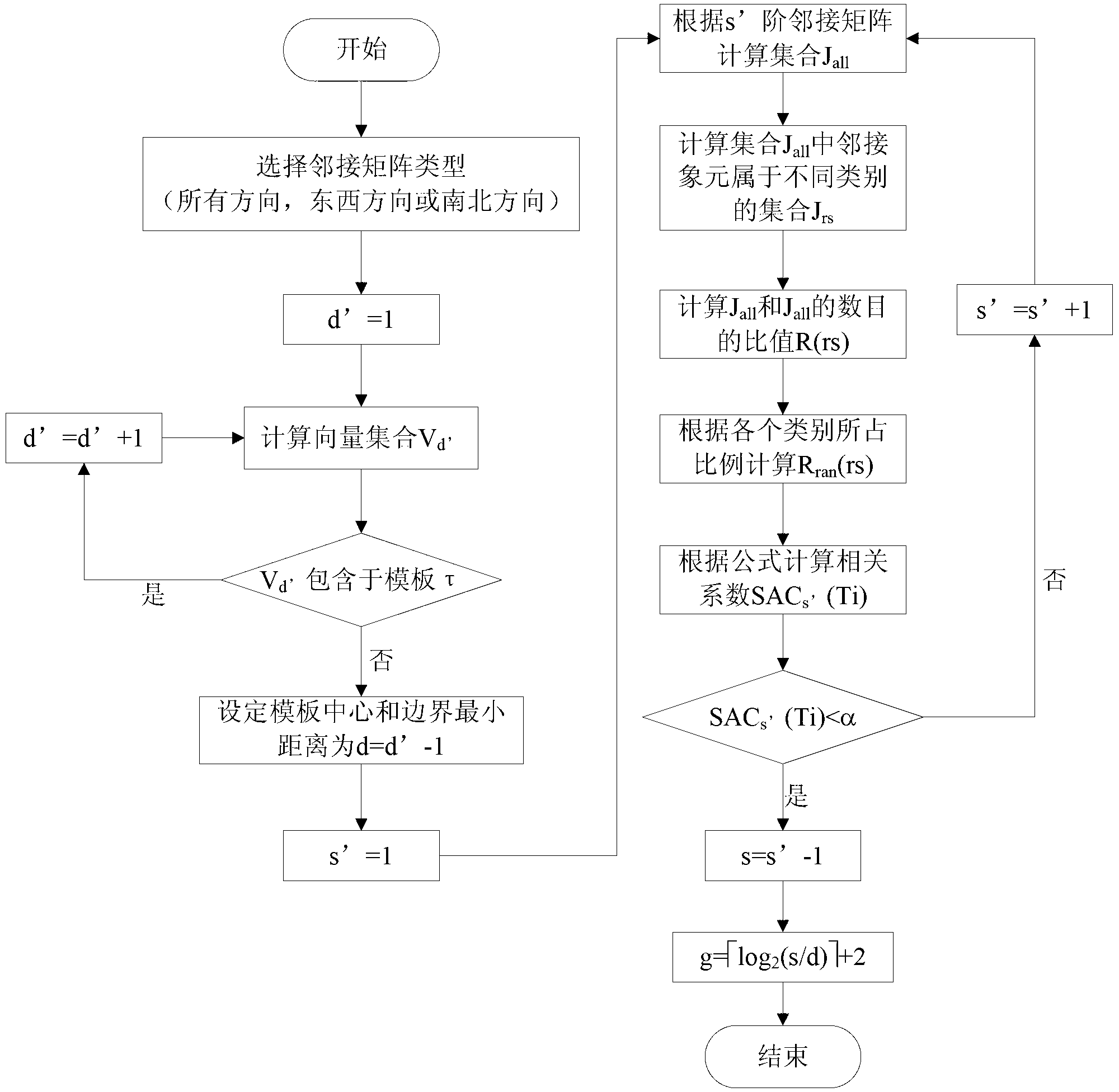
[0045] The whole implementation process can be divided into four steps:

[0046] (1) Choose an adjacency matrix.

[0047] The target object in this example is a circle, which is a typical isotropic object, so it is necessary to comprehensively consider the spatial scales in all directions. Therefore, the adjacency matrix where if|i x -j x |+|i y -j y |=k, then w k dis ( i , j ) = 1 , otherwise w ...

Embodiment 2

[0056] The first example simulates typical anisotropic objects. The target objects used here are assumed to have striped features. Here, the two types of objects are simply named as white objects and black objects according to their colors. . Figure 5 is the training image required for multi-point simulation, with a size of 250×250. image 3 It is a template required for multipoint simulation.

[0057] The entire implementation process is also divided into four steps:

[0058] (1) Choose an adjacency matrix.

[0059] The target objects in this example have typical east-west striping characteristics, so only the spatial scale in the east-west direction needs to be considered. Therefore, the adjacency matrix where if|i x -j x |=0 and |i y -j y |=k, then w k ES ( i , j ) = 1 , otherwise w ...


PUM


Abstract

A method for geography phenomenon multi-point simulation spatial scale selection comprises the steps of (1) calculating the shortest distance between a template center and a boundary, (2) calculating the critical distance, smaller than a predetermined threshold value, of the spatial correlation of a training image, and (3) determining the size of spatial scale needing to be considered, namely the number of multiple grids according to the shortest distance between the template center and the boundary and the critical distance of the spatial correlation. According to the method for the geography phenomenon multi-point simulation spatial scale selection, the size of the spatial scale needed can be determined according to the spatial correlation before multi-point simulation, and therefore subjectivity and uncertainty existing when spatial scale selection is achieved by using expert experience are avoided, and a parameter determining method of the number of the multiple grids is provided for relevant issues in production and life, such as petroleum reservoir simulation. The method for the geography phenomenon multi-point simulation spatial scale selection can be applied to fields such as geology and mineral products, weather, remote sensing, ocean research, military reconnaissance and environmental monitoring.

Description

technical field [0001] The invention belongs to the technical field of spatial information, and in particular relates to a method for determining the parameter of the multi-grid number when multi-grid is used for simulation in multi-point simulation. technical background [0002] Simulation has always been a common technique and method for studying geographical phenomena. For example, in many aspects such as meteorology and geology, many studies are about how to simulate the actual distribution of research objects in the research area from limited sample points. In the 1990s, Guardiano, Srivastava and Journal proposed the theoretical method of using multi-point statistics to model geographic phenomena, that is, multi-point simulation. This method can make up for the deficiency of the traditional geostatistical variogram: only the statistical relationship between two points is considered. Based on this idea, experts have proposed many related algorithms and verified them. ...

Claims


Application Information

Patent Timeline
Patent Type & Authority Applications(China)
IPC IPC(8): G06F19/00
Inventor 白鹤翔葛咏李德玉翟岩慧曹峰
Owner SHANXI UNIV
Why Eureka
Try Eureka