

Method for automatic caching construction of massive timing sequence remote-sensing images in cloud environment
A remote sensing image and automatic caching technology, which is applied in the intersection of geographic information and cloud computing technology, can solve the problems of work efficiency, the lack of full use of MapReduce data localization computing characteristics, and the inability to meet the requirements of cache construction, etc., to achieve good universality sexual effect
- Summary
- Abstract
- Description
- Claims
- Application Information
AI Technical Summary
Problems solved by technology
Method used
Image

Examples
Embodiment Construction
[0038] The technical solution of the present invention will be described in detail below in conjunction with the drawings and embodiments.
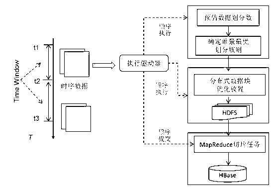
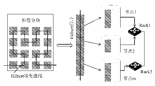
[0039] The caching grid model used in the embodiment is: Global Logical Tile Scheme, which is under geodetic projection with 2 n+1 The multi-level longitude and latitude grid divided by ×2n is used as the basis to establish a global map tile division. The first layer is a 2 (longitude direction)×1 (dimensional direction) grid, and the grid units of this layer can be further subdivided into high-level grids by quadtree division. For details, see the literature "John T.Sample, Elias Loup: Tile-Based Geospatial Information Systems. Principles and Practices. New York, 2010, pp.7-9."
[0040] The adopted cloud environment is built with the MapReduce framework in the Hadoop software stack, the HDFS distributed file system, and the HBase columnar database. The hardware environment is a distributed cluster environment including multiple Racks e...
PUM
 Abstract
Description
Claims
Application Information