Method for determining natural wetland restoration plan based on remote sensing images and GIS (geographic information system) spatial analyses

A technology for spatial analysis and restoration schemes, applied in special data processing applications, instruments, climate change adaptation, etc., can solve problems such as research, analysis focusing on positioning, and not from a quantitative perspective, and achieve large-scale wetland restoration and wetland restoration. The effect of increasing the area

Inactive Publication Date: 2013-09-11
NORTHEAST INST OF GEOGRAPHY & AGRIECOLOGY C A S
View PDF2 Cites 8 Cited by
  • Summary
  • Abstract
  • Description
  • Claims
  • Application Information

AI Technical Summary

Problems solved by technology

[0004] In order to solve the problem that the traditional wetland restoration method focuses on positioning, does not conduct research from a quantitative perspective, and does not fully integrate GIS space analysis technology, the present invention provides a method for determining a natural wetland restoration plan based on remote sensing images and GIS space method

Method used


Image

  • Method for determining natural wetland restoration plan based on remote sensing images and GIS (geographic information system) spatial analyses
  • Method for determining natural wetland restoration plan based on remote sensing images and GIS (geographic information system) spatial analyses
  • Method for determining natural wetland restoration plan based on remote sensing images and GIS (geographic information system) spatial analyses

Examples


specific Embodiment approach 1

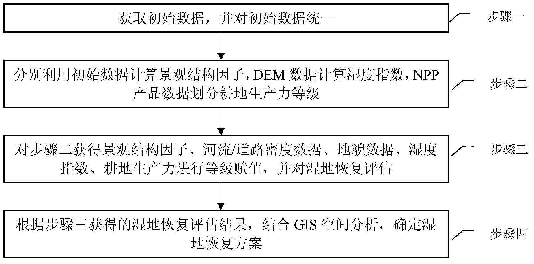
[0015] Specific implementation mode 1. Combination figure 1 This specific embodiment will be described. A method for determining a natural wetland restoration scheme based on remote sensing images and GIS spatial analysis, which includes the following steps:

[0016] Step 1: Obtain initial data and unify the initial data;

[0017] The initial data includes land use data, DEM data, river / road density data, landform data and NPP product data;

[0018] Step 2: Use the initial data to calculate the landscape structure factor, the DEM data to calculate the humidity index, and the NPP product data to divide the cultivated land productivity level;

[0019] Step 3: Assign grades to the landscape structure factors, river / road density data, landform data, humidity index, and cultivated land productivity obtained in Step 2, and evaluate wetland restoration;

[0020] Step 4: Based on the wetland restoration assessment results obtained in Step 3, combined with GIS spatial analysis, dete...

specific Embodiment

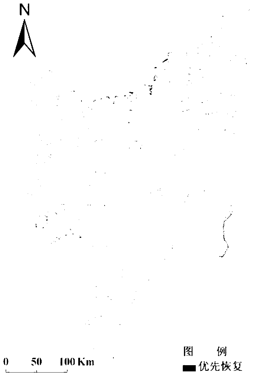
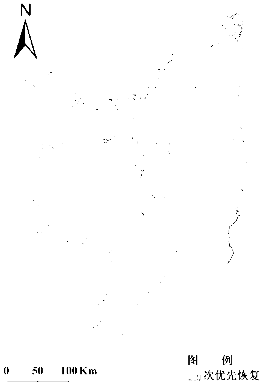
[0055] Specific examples: combining figure 2 and image 3 This specific example will be described.

[0056] Using the method of natural wetland restoration combined with remote sensing and GIS to realize the spatial restoration of natural wetland in Sanjiang Plain. The specific operation steps are as follows:

[0057] Obtain plain data and process the original data. The data involved include land use data; DEM data; river and road density data; landform data and Modis NPP product data. The land use data is obtained from TM remote sensing images through manual visual interpretation; the river and road vector data are extracted from the land use data. Under the ArcGIS9.3 data processing platform, the Line Density command is used to generate the river and road density maps respectively. Geomorphic data is generated by scanning, digitizing and cartographically integrated 1:250,000 geomorphic map. According to the analysis requirements in this paper, the geomorphic types are divi...


PUM


Abstract

The invention discloses a method for determining a natural wetland restoration plan based on remote sensing images and GIS (geographic information system) spatial analyses, relates to the method for determining the natural wetland restoration plan, and solves the problems that a conventional natural wetland restoration plan rather focuses on analyses of positioning than researching from a quantitative angle and combining with a GIS spatial analysis technology sufficiently. The method includes steps of 1), acquiring initial data and unifying the same; 2), utilizing the initial data to calculate landscape structure factors, DEM (digital elevation model) data to calculate humidity index and NPP (net primary product) data to divide cultivated land productivity grades; 3), subjecting the landscape structure factors, rivers / roads / density data, terrain data, the humidity index and the cultivated land productivity level acquired in the step 2) to grading, and a wetland to restoration evaluation; 4), determining the wetland restoration plan combined with the GIS spatial analyses and according to wetland restoration evaluation results acquired in the step 3). The method is widely applicable to determination of large-scale wetland restoration plans.

Description

technical field [0001] The invention relates to a method for determining a natural wetland restoration scheme. Background technique [0002] Due to over-exploitation and utilization, global wetlands have disappeared and degraded, causing serious ecological microcomputer and social problems. Therefore, it is imminent to restore wetlands by combining natural and artificial means. Wetland restoration refers to the restoration or reconstruction of degraded or disappeared wetlands through ecological technology or ecological engineering, to reproduce the structure and function before disturbance, as well as related physical, chemical and biological characteristics, so that it can play its due role. In recent years, with the increase of human activities, the wetland ecosystem has been severely degraded, causing a series of regional environmental problems such as climate drying, groundwater level drop, soil degradation and fertility depletion, animal and plant resources reduction, a...

Claims


Application Information

Patent Timeline
Patent Type & Authority Applications(China)
IPC IPC(8): G06F19/00
CPCY02A40/22
Inventor 王宗明董张玉刘殿伟任春颖汤旭光贾明明丁智邵田田
Owner NORTHEAST INST OF GEOGRAPHY & AGRIECOLOGY C A S
Why Eureka
Try Eureka