Implement method of lightweight-class global multi-dimensional remote-sensing image network map service

A remote sensing image and network map technology, applied in the field of remote sensing image data online service, can solve the problem of not supporting the multi-dimensional features of remote sensing data, achieve the effect of clear and simple structure, reduce data reading time, and support incremental update

Active Publication Date: 2013-12-18
HUBEI UNIV OF ARTS & SCI
View PDF2 Cites 63 Cited by
  • Summary
  • Abstract
  • Description
  • Claims
  • Application Information

AI Technical Summary

Problems solved by technology

In addition, these commercial web map service systems do not support multi-dimensional features of remote sensing data (such as multi-data types, multi-temporal and multi-spectral features, etc.)

Method used


Image

  • Implement method of lightweight-class global multi-dimensional remote-sensing image network map service
  • Implement method of lightweight-class global multi-dimensional remote-sensing image network map service
  • Implement method of lightweight-class global multi-dimensional remote-sensing image network map service

Examples


Embodiment Construction

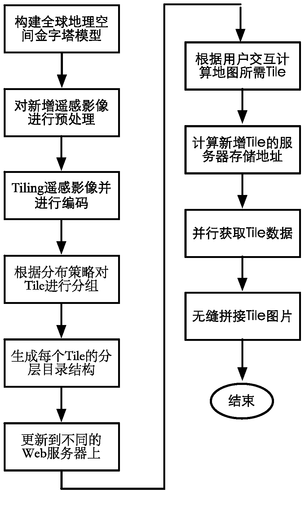
[0062] The technical solution of the present invention will be described in detail below in conjunction with the drawings and embodiments.

[0063] Such as figure 1 As shown, the specific steps of the embodiment of the present invention are as follows:

[0064] 1. Construct a global geospatial pyramid model

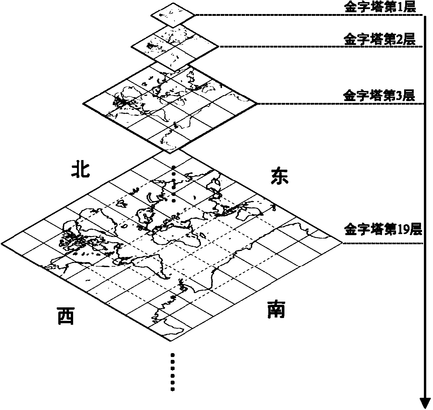
[0065] This method is based on the Global Geospatial Pyramid Model (GGPM) to organize global multi-dimensional remote sensing data. GGPM is different from the traditional image pyramid model. It constructs a multi-resolution pyramid structure by layer-by-layer extraction from existing remote sensing image data. , GGPM builds a pyramid structure by dividing the global geographic space from top to bottom. Each layer of the pyramid corresponds to the entire earth plane, such as figure 2 As shown, the first layer of the pyramid, the second layer of the pyramid, the third layer of the pyramid...the 19th layer of the pyramid...are constructed sequentially from top to bottom....


PUM


Abstract

The invention provides an implement method of lightweight-class global multi-dimensional remote-sensing image network map service. The implement method comprises the following steps: a global geographic space pyramid model is constructed, and a Tile file encoding system is built according to the model; pre-treatment mainly comprising projection transformation, file format conversion and the like is performed on the remote-sensing data so as to cut the remote-sensing data into tiles, and file encoding is performed; according to a distribution strategy, Tile files are grouped to generate a corresponding directory structure, and different images are updated on different Web servers; the visible range of the map requested by a client side is analyzed to calculate the storage paths of all images within the visible range, and the images are loaded and fed back to the client side. According to the invention, the implement method of the light-weight-class global multi-dimensional remote-sensing image network map service can be provided for a remote-sensing data center (such as the China Center for Resources Satellite Data and Application) and can provide remote-sensing data service to users more conveniently.

Description

technical field [0001] The invention relates to a lightweight global multi-dimensional remote sensing image network map service implementation method, which is mainly used for remote sensing data providers to provide users with remote sensing image data online services through network maps. Background technique [0002] Satellite remote sensing has become a major data source for Earth observation because satellites can rapidly provide remote sensing data with global coverage and consistent data quality. Through satellite remote sensing, humans have gained a broader scientific understanding of the Earth and how it works over the past few decades. Applications of this knowledge, from weather forecasting to resource management, have demonstrated the enormous benefits of remote sensing to human society. In just the past 20 years, remote sensing data has increased the accuracy of weather forecasts within five days from 65 percent to 85 percent. Remote sensing data is very impor...

Claims


Application Information

Patent Timeline
Patent Type & Authority Applications(China)
IPC IPC(8): G06F17/30
Inventor 胡春阳吴钊杭波谷琼吴中博
Owner HUBEI UNIV OF ARTS & SCI
Why Eureka
Try Eureka