Automatic classifying and identifying method for road line point cloud based on three-dimensional laser reflection strength

A 3D laser and road marking technology, applied in character and pattern recognition, photo interpretation, measuring devices, etc., can solve the problems of strict air flight image data collection conditions, low work efficiency, and difficult acquisition, and achieve repeated troubleshooting Convenient error detection, less field time, and improved work efficiency

Active Publication Date: 2014-01-08
WUHAN HI TARGET DIGITAL CLOUD TECH CO LTD
View PDF3 Cites 25 Cited by
  • Summary
  • Abstract
  • Description
  • Claims
  • Application Information

AI Technical Summary

Problems solved by technology

The collection and identification of road markings based on the traditional surveying and mapping methods based on total stations include the traditional operation method of geodetic step-by-step collection based on total stations, and the selective extraction based on aerial remote sen

Method used


Image

  • Automatic classifying and identifying method for road line point cloud based on three-dimensional laser reflection strength
  • Automatic classifying and identifying method for road line point cloud based on three-dimensional laser reflection strength
  • Automatic classifying and identifying method for road line point cloud based on three-dimensional laser reflection strength

Examples


Embodiment 1

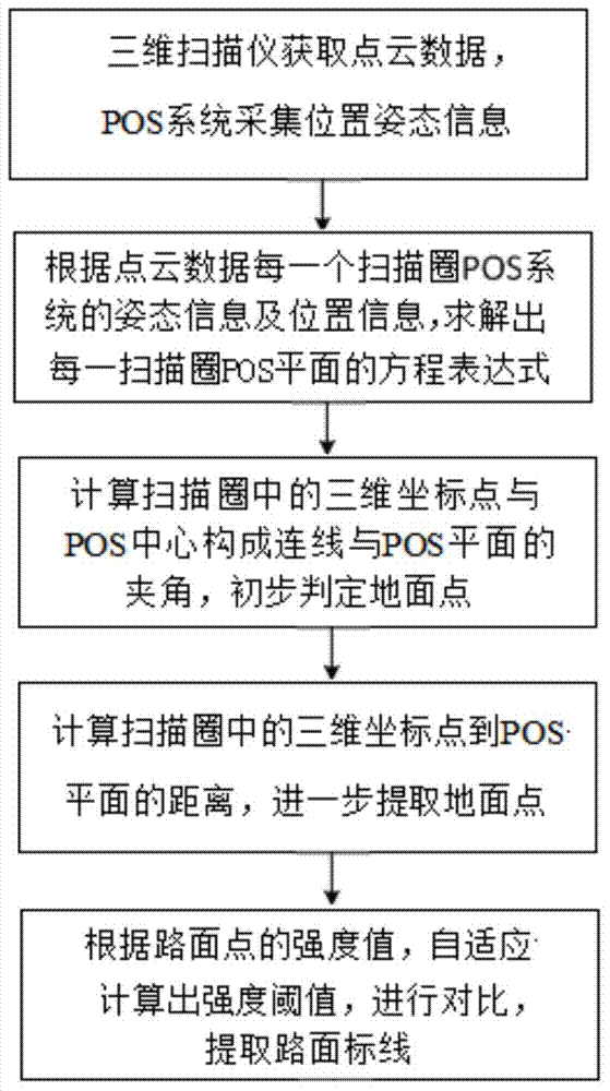
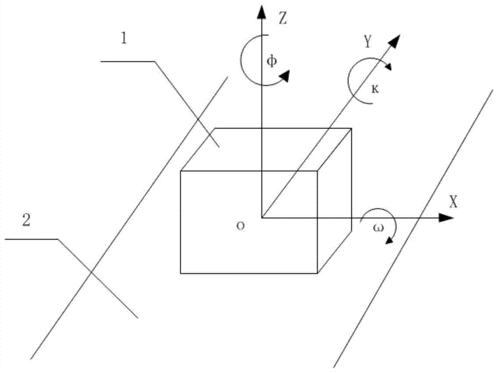
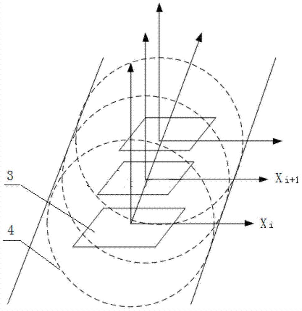
[0029] Embodiment 1: A method for automatic classification and recognition of road marking point clouds based on three-dimensional laser reflection intensity proposed by the present invention, the entire method flow is as follows figure 1 shown. The specific operation is: first, use the vehicle-mounted 3D laser measurement system to collect data. The integrated components of the vehicle-mounted 3D laser mobile measurement system include vehicle 1, 3D laser scanner, GPS navigator, inertial guidance system and panoramic camera. The data collection process is performed in vehicle 1. During driving, the 3D laser scanner is used to obtain point cloud data, and the POS system composed of GPS navigator and inertial guidance system is used to obtain attitude and position information; the point cloud data is organized according to the circle index to obtain the scanning circle of each circle. 3D coordinate point set; according to the time alignment, according to the interpolation settl...


PUM


Abstract

The invention relates to an automatic classifying and identifying method of a road line point cloud based on three-dimensional laser reflection strength. The automatic classifying and identifying method comprises the following operation steps of acquiring point cloud data by utilizing a laser scanner, and calculating an equation of a POS plane of each scanning circle according to the attitude and position information of a POS system in each scanning circle of the point cloud data; calculating included angles between the connecting lines of three-dimensional coordinate points and the centers of the POS planes and the POS planes in the scanning circles, comparing the included angles with an angle threshold, and primarily judging the points larger than the angle threshold as pavement points; recalculating the distances from the primarily judged pavement points to the POS planes, in which the points are located, of the scanning circles, taking the height H of the POS system during the mounting as a known value, comparing difference values between the calculated distance values and a height value H, and taking the points smaller than the threshold as the pavement points; counting the strength values of the secondarily judged pavement points, and judging the points with the strength values larger than the threshold value as the road lines. The automatic classifying and identifying method has the advantages of rapidness, high efficiency, repetition in checking and convenience in error detection.

Description

technical field [0001] The invention relates to an automatic classification and recognition method for road marking point clouds based on three-dimensional laser reflection intensity, and belongs to the technical fields of photogrammetry and three-dimensional laser. Background technique [0002] Road markings are one of the important symbols of the urban environment and are of great significance to urban traffic planning, order maintenance and management. The collection and identification of road markings based on the traditional surveying and mapping methods based on total stations include the traditional operation method of geodetic step-by-step collection based on total stations, and the selective extraction based on aerial remote sensing images. However, the former has a huge amount of field collection and low work efficiency. The latter has higher requirements on the spatial resolution of image data, while the acquisition conditions of high-resolution aerial image data ...

Claims


Application Information

Patent Timeline
IPC IPC(8): G01C11/00G06K9/46
CPCG01C11/18G06V10/462
Inventor 危迟龚书林
Owner WUHAN HI TARGET DIGITAL CLOUD TECH CO LTD
Why Eureka
Try Eureka