Lane Line Automatic Recognition Method Based on Low Altitude Aerial Images

An aerial image and automatic recognition technology, which is applied in the field of traffic information, can solve problems such as road extraction that are not involved, and achieve the effects of fast calculation speed, simple calculation and high reliability

Active Publication Date: 2016-08-17
BEIHANG UNIV
View PDF4 Cites 18 Cited by
  • Summary
  • Abstract
  • Description
  • Claims
  • Application Information

AI Technical Summary

Problems solved by technology

The existing video processing method for the dynamic camera of low-altitude aircraft is based on the machine learning method to identify the image vehicle, and does not involve road extraction technology

Method used


Image

  • Lane Line Automatic Recognition Method Based on Low Altitude Aerial Images
  • Lane Line Automatic Recognition Method Based on Low Altitude Aerial Images
  • Lane Line Automatic Recognition Method Based on Low Altitude Aerial Images

Examples


Embodiment Construction

[0039] In order to make the object, technical solution and advantages of the present invention more clear, the present invention will be further described in detail below in conjunction with the accompanying drawings and embodiments.

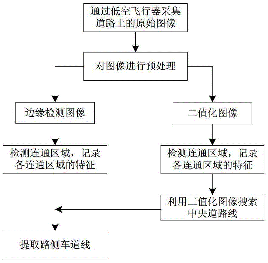
[0040] Such as figure 1 Shown is the method for automatic recognition of lane lines based on low-altitude aerial images of the present invention, including steps 1 to 5. Step 1: Use a low-altitude aircraft to collect the original image of the aerial road, and ensure that the shooting angle of the aerial road is in the horizontal direction, and the road area is located in the middle of the image.

[0041] Step 2, preprocessing the collected original image.

[0042] In order to ensure the processing speed, firstly, the width and height are compressed to obtain an image with a width of W and a height of H.

[0043] Then perform grayscale processing, and improve the contrast of the grayscale image, and copy the obtained grayscale image.

[0044] ...


PUM


Abstract

The invention provides a method for automatically recognizing lane lines based on low-altitude aerial images, which is used in the field of intelligent transportation. The original image on the road is collected by a low-altitude aircraft to ensure that the shooting angle of the aerial road is in the horizontal direction, and the road area is located in the middle of the image; the collected image is converted into a grayscale image and the contrast is improved, and the grayscale image is copied. Image acquisition edge detection image and binary image; detect connected regions in edge detection image and binary image and record the characteristics of each connected region; according to the number of pixels in the connected region, the number of connected boundaries, and the size of the circumscribed rectangle and the variance value to delete the connected area to get the central road line; search on both sides of the central road line to find the roadside lane line. The invention has the advantages of simple calculation, fast calculation speed and high reliability, can effectively extract the road part in the aerial video, can detect straight roads and detours in the aerial image, is not disturbed by background changes, and has high accuracy.

Description

technical field [0001] The invention belongs to the field of traffic information, and relates to a method for automatically recognizing lane lines in low-altitude aerial images in the field of intelligent transportation technology, in particular to a method for identifying and extracting curves in aerial images. Background technique [0002] Due to the dense population in China, the traffic conditions in large and medium-sized cities are becoming more and more congested. Accidents on highways, snow disasters and other special circumstances will lead to traffic paralysis, causing great hidden dangers to driving safety and great inconvenience to citizens' daily travel. At present, traffic state awareness is mainly based on roadbed means, which can only obtain cross-sectional information of discrete point sampling, and it is difficult to obtain continuous and large-scale real-time situation information. Traditional ground traffic command methods cannot cover all road sections an...

Claims


Application Information

Patent Timeline
Patent Type & Authority Patents(China)
IPC IPC(8): G06K9/00
Inventor 王云鹏余贵珍郑欣蕊徐永正张毅鹏
Owner BEIHANG UNIV
Why Eureka
Try Eureka