Satellite-borne passive radar location method based on GNSS-R (global navigation satellite system-reflection) signal geometrical relationship

A passive radar, positioning method technology, applied in satellite radio beacon positioning system, radio wave measurement system, radio wave reflection/re-radiation and other directions, can solve the problems of increasing the complexity of the positioning algorithm, too many parameters, etc.

Inactive Publication Date: 2014-02-12
BEIHANG UNIV +1
View PDF3 Cites 14 Cited by
  • Summary
  • Abstract
  • Description
  • Claims
  • Application Information

AI Technical Summary

Problems solved by technology

Most of the current positioning methods use the time delay difference between the reflected signal and the direct signal to list the nonlinear equations, and use the redundancy in the equations to convert the nonlinear equations into linear equations for calculat

Method used


Image

  • Satellite-borne passive radar location method based on GNSS-R (global navigation satellite system-reflection) signal geometrical relationship
  • Satellite-borne passive radar location method based on GNSS-R (global navigation satellite system-reflection) signal geometrical relationship
  • Satellite-borne passive radar location method based on GNSS-R (global navigation satellite system-reflection) signal geometrical relationship

Examples


Embodiment Construction

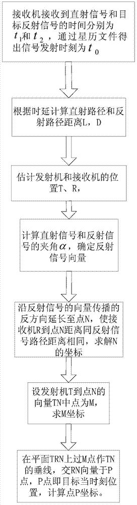
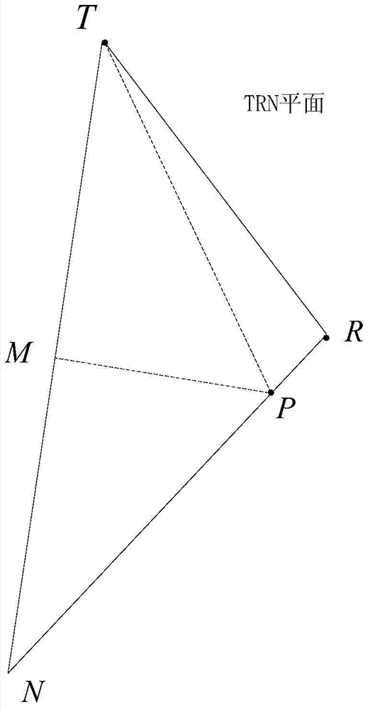
[0087] See figure 1 , 2 , in the WGS-84 coordinate system, in meters, let the R coordinate of the receiver be (-4069896, -3583236, 4527639), and the T coordinate of the transmitter be (-11178791, -13160191, 20341528), the measured reflected signal and The angle between the direct signal and the velocity direction of the receiver is arccos(-0.1394), the angle between the reflected signal and the normal vector of the moving plane is arccos(0.5881), and the normal vector of the moving plane is arccos(0.5881). The vector is (-4069896, -3583236, 4527639), the receiver velocity vector is (-4738, -1796, -5654), and the direct signal vector is (7108895, 9576955, -15813889)

[0088] A kind of target positioning method based on GNSS-R geometric relation of the present invention concrete steps are as follows:

[0089] Step 1: The moment when the receiver receives the direct signal from the GPS satellite is t 1 , the ephemeris file in the GPS signal contains the launch time t 0 , in ...


PUM


Abstract

A satellite-borne passive radar location method based on a GNSS-R (global navigation satellite system-reflection) signal geometrical relationship comprises steps as follows: step one, the moment when a receiver receives a direct signal of a GPS satellite is marked as t1, and the moment when the receiver receives a reflected signal to a target by a related GPRS satellite signal is marked as t2; step two, a direct path length L and a reflection path length D of the signal are calculated according to the arrival moment of the signal; step three, the position coordinate T ( xt, yt, zt) and the position coordinate R (xr, yr, zr) of a transmitter and the receiver are calculated; step four, the included angle alpha between the direct signal and the reflected signal is calculated, and the vector of the reflected signal is determined; step five, the vector of the reflected signal is lengthened to the point N in the transmission direction, so that the distance between R of the receiver and the point N is equal to the distance of the reflected signal path, and a coordinate of N is calculated; step six, a midpoint of a vector TN from T of the transmitter to the point N is set to be M, and a coordinate of M is calculated; and step seven, a TN vertical line passing the point M is drawn on a plane TRN, the vertical line intersects with a vector RN at the point P which is the position of the target at the moment, and a coordinate of the point P is calculated. According to the method, the calculation difficulty is reduced, the location efficiency is improved, and the location cost is reduced.

Description

(1) Technical field: [0001] The invention relates to a single-satellite passive radar sea surface and offshore target positioning method, in particular to the geometric relationship between the receiver, the transmitter and the target based on the Global Navigation Satellite System Reflect signal (GNSS-R) The positioning method can be used for low-altitude offshore targets and single target positioning on the sea surface, and is suitable for passive radar receivers with rotating receiving antennas or systems with angle measurement functions. The method can realize simple and efficient single-satellite positioning, and belongs to the technical field of wireless communication. (2) Technical background: [0002] Radar systems are an important pillar of homeland air defense. Since they were officially equipped in the 1940s, they have played an important role in target detection, positioning and tracking due to their advantages such as long range, all-weather, and little impact o...

Claims


Application Information

Patent Timeline
IPC IPC(8): G01S13/06
CPCG01S13/06G01S19/42
Inventor 修春娣吕佩珊寄文星姚崇斌周勃
Owner BEIHANG UNIV
Why Eureka
Try Eureka