Road traffic state estimation method based on microwave radar data

A technology of road traffic and microwave radar, which is applied in the field of intelligent transportation, can solve the problems of poor adaptive ability, poor practicability, and unsustainable models, and achieve high discrimination accuracy and good sustainability

Active Publication Date: 2014-02-12
ENJOYOR COMPANY LIMITED
View PDF2 Cites 20 Cited by
  • Summary
  • Abstract
  • Description
  • Claims
  • Application Information

AI Technical Summary

Problems solved by technology

[0006] In order to overcome the disadvantages of existing road traffic state estimation methods such as lack of sustainability, poor adaptability, and poor practicability, the present invention provides a model with good sustainability, strong adaptability, and practicality. A good road traffic state estimation method based on microwave radar data

Method used


Image

  • Road traffic state estimation method based on microwave radar data
  • Road traffic state estimation method based on microwave radar data
  • Road traffic state estimation method based on microwave radar data

Examples


Embodiment Construction

[0041] The present invention will be further described below in conjunction with the accompanying drawings.

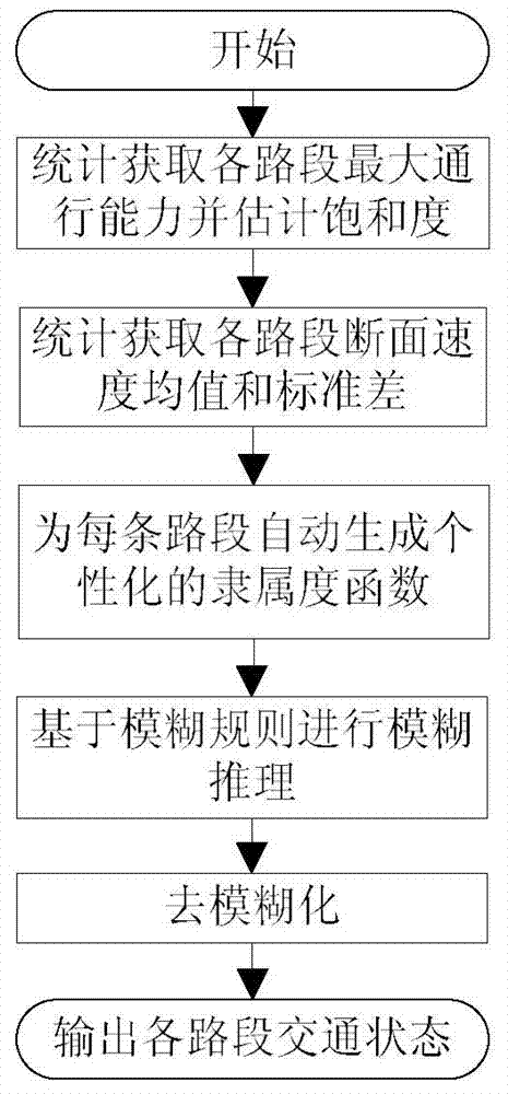
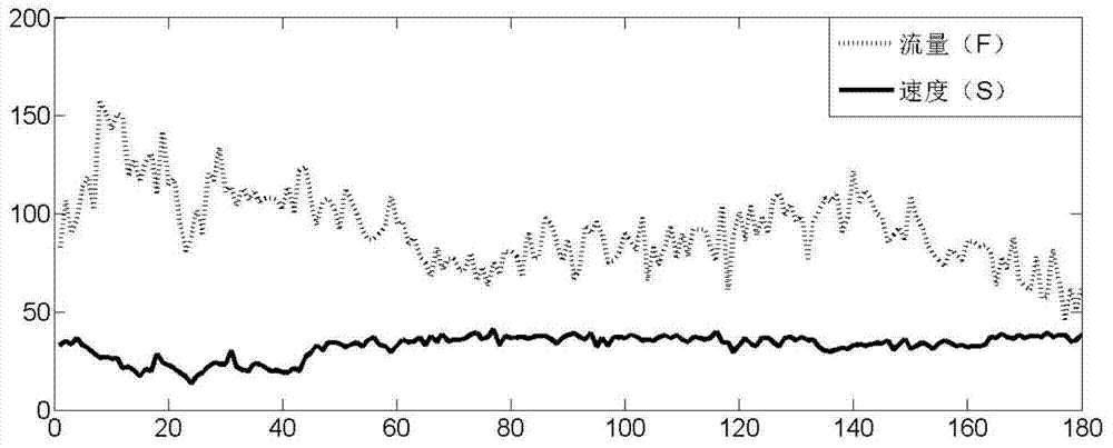
[0042] refer to Figure 1 to Figure 8 , a road traffic state estimation method based on microwave radar data, the microwave radar measures the average vehicle speed, flow rate and time occupancy rate of each lane section within a certain time interval. After statistical analysis, the average speed of the cross-section detected by the microwave is generally significantly greater than the average speed detected by the floating car. Therefore, it is not reasonable to use the speed threshold of the floating car and the average speed of the cross-section to determine the traffic state. This program will design a fuzzy reasoning method that is easy to use, supported by statistics, and conforms to traffic engineering theory. This technology uses the two indicators of section average speed and saturation as the main variables. The flow chart of the road traffic state estimati...


PUM


Abstract

Disclosed is a road traffic state estimation method based on microwave radar data. The method includes the steps that firstly, the maximum traffic capacity of road segments is acquired through statistics, and saturability is estimated; secondly, the mean value and standard difference of cross section speeds of a traffic flow lasting five minutes on each road segment are calculated through statistics; thirdly, an individualized subordinating degree function is automatically generated for each road segment; fourthly, a smoothness constant, a slow moving constant and a congestion constant are given respectively based on fuzzy rules, the strength of each rule is calculated for each set of input data (speed and saturability), three output maximum rule strengths are sequentially recorded as w1, w2 and w3, and then an output value Z is worked out through the weighted average method; fifthly, it is judged that traffic is smooth if the final value Z is the most approximate to the smoothness constant, it is judged that cars need to run slowly if the final value Z is the most approximate to the slow moving constant, and it is judged that the traffic is congested if the final value Z is the most approximate to the congestion constant. A model of the method has good continuity, high adaptive ability and good practicability.

Description

technical field [0001] The invention belongs to the field of intelligent traffic, and relates to a method for estimating urban road traffic states. Background technique [0002] Urban traffic state estimation refers to the use of data collected by traffic sensors, based on the basic theory of traffic engineering and people's cognitive habits, and the use of reasonable information science methods to determine the actual operating state of a group of road sections in real time. Typically, the running status of the link includes: smooth, slow and congested. Currently, the main traffic state estimation methods are technology based on floating car data and technology based on ground induction coils. Floating car technology only needs to judge the traffic state according to the speed threshold. Although this method is simple and practical, due to the unbalanced spatio-temporal distribution of floating cars, the obtained data has space-time gaps and a high missing rate. Typically...

Claims


Application Information

Patent Timeline
Patent Type & Authority Applications(China)
IPC IPC(8): G08G1/01
Inventor 李建元柳展徐建军温晓岳吕卓周煜远
Owner ENJOYOR COMPANY LIMITED
Why Eureka
Try Eureka