Mallat algorithm-based marine gravity measurement error eliminating method

A technology of gravity measurement and error elimination, applied in measurement devices, measurement of gravitational fields, geophysical measurement, etc., can solve the problem that Fourier transform cannot meet the requirements of signal processing.

Inactive Publication Date: 2014-02-26
HARBIN ENG UNIV
View PDF0 Cites 13 Cited by
  • Summary
  • Abstract
  • Description
  • Claims
  • Application Information

AI Technical Summary

Problems solved by technology

[0004] The purpose of the embodiments of the present invention is to provide a method for eliminating ocean gravity measurement errors based on the Mallat algorithm, which aims to solve the problem that traditiona

Method used


Image

  • Mallat algorithm-based marine gravity measurement error eliminating method
  • Mallat algorithm-based marine gravity measurement error eliminating method
  • Mallat algorithm-based marine gravity measurement error eliminating method

Examples


Embodiment Construction

[0069] In order to make the object, technical solution and advantages of the present invention more clear, the present invention will be further described in detail below in conjunction with the examples. It should be understood that the specific embodiments described here are only used to explain the present invention, not to limit the present invention.

[0070] The application principle of the present invention will be further described below in conjunction with the accompanying drawings and specific embodiments.

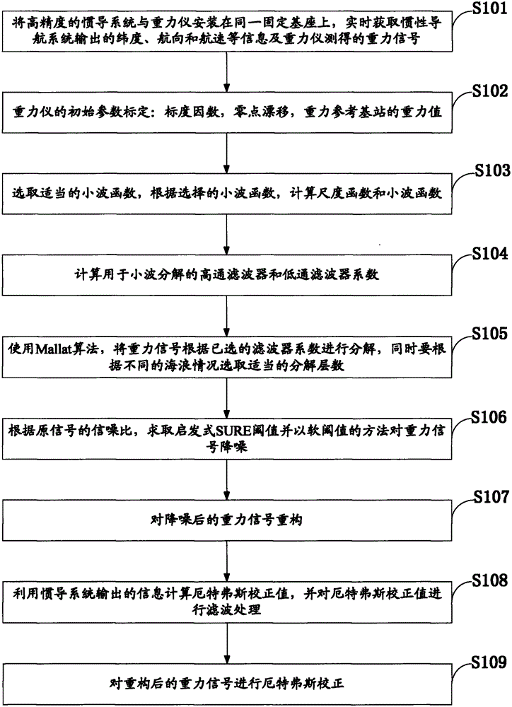
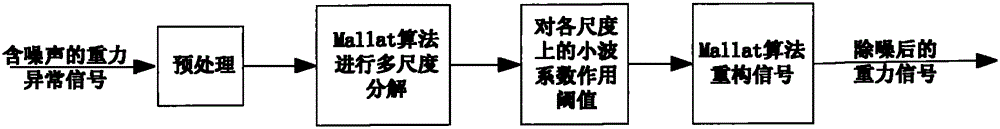
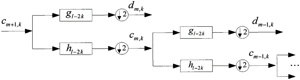
[0071] Such as figure 1 As shown, the Mallat algorithm-based marine gravity measurement error elimination method of the embodiment of the present invention includes the following steps:

[0072] S101: Install the high-precision inertial navigation system and the gravimeter on the same fixed base, and obtain the latitude, heading and speed information output by the inertial navigation system and the gravity signal measured by the gravimeter in real time;

[0073...


PUM


Abstract

Disclosed in the invention is a Mallat algorithm-based marine gravity measurement error eliminating method. The method comprises the following steps: obtaining latitude, course, and ship speed information outputted by an inertial navigation system as well as a gravity signal measured by a gravity meter in real time; calibrating an initial parameter of the gravity meter; selecting a wavelet function and calculating a scaling function phi (t) and a wavelet function psi (t); calculating coefficients of a high-pass filter and a low-pass filter; carrying out decomposition on the gravity signal by using a Mallat algorithm according to the selected filter coefficients and selecting a decomposition level number; according to a signal to noise ratio of an original signal, calculating a heuristic SURE threshold value and carrying out noise reduction on the gravity signal based on a soft threshold method; reconstructuring the gravity signal after noise reduction, calculating an Etvs correction value by utilizing the information outputted by the inertial navigation system and carrying out filtering processing on the Etvs correction value; and carrying out Etvs correction on the gravity signal after the reconstruction. According to the invention, a defect of insufficient real-time performance during the gravity measurement can be overcome; a main error during the gravity measurement can be eliminated; and the gravity signal precision is improved.

Description

technical field [0001] The invention belongs to the technical field of marine gravity measurement, in particular to a method for eliminating errors in marine gravity measurement based on Mallat algorithm. Background technique [0002] In the 1980s and 1990s, the United States and the former Soviet Union successively began to develop passive navigation assistance systems for strategic underwater vehicles. The initial auxiliary method is based on graphic matching, including matching with seabed topographic maps and magnetic field maps. However, due to the need to use sonar to measure seabed contours, the concealment of seabed topography matching is weak; at the same time, it is difficult to actually use it due to the complexity of magnetic field changes. In underwater vehicle navigation, gravity signals and gravity gradient data become the main passive information resources for underwater vehicle navigation. Gravity-assisted navigation has the advantages of high precision, st...

Claims


Application Information

Patent Timeline
IPC IPC(8): G01V7/00G01V7/06
Inventor 周广涛姜鑫赵博夏秀玮郝勤顺孙艳涛于春阳赵维珩
Owner HARBIN ENG UNIV
Why Eureka
Try Eureka