Method for identifying monocular visual spaces in terrestrial gravitational field environments

A monocular vision and spatial recognition technology, applied in the field of image processing, can solve problems such as poor adaptability, slow speed, and large data processing volume.

Active Publication Date: 2014-03-12
NANJING YUANJUE INFORMATION & TECH CO NANJING
View PDF7 Cites 16 Cited by
  • Summary
  • Abstract
  • Description
  • Claims
  • Application Information

AI Technical Summary

Problems solved by technology

[0003] The purpose of the present invention is to solve the problems that most of the existing image recognition methods need to be learned through image learning. These methods have the problems of large data processing capac...

Method used


Image

  • Method for identifying monocular visual spaces in terrestrial gravitational field environments
  • Method for identifying monocular visual spaces in terrestrial gravitational field environments
  • Method for identifying monocular visual spaces in terrestrial gravitational field environments

Examples


Embodiment Construction

[0033] The following structural examples and accompanying drawings further illustrate the present invention.

[0034] Such as Figure 1-14 shown.

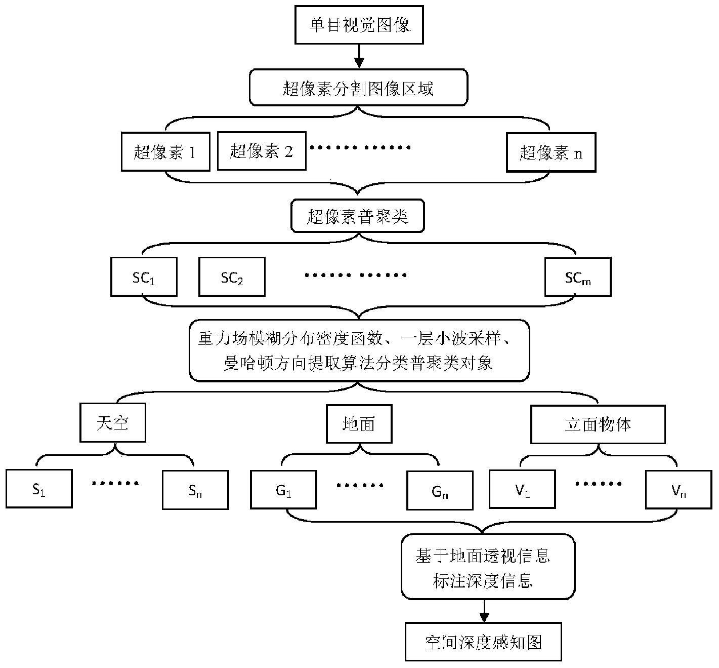
[0035] A monocular visual space recognition method under a similar earth gravity field environment, it comprises the following steps:

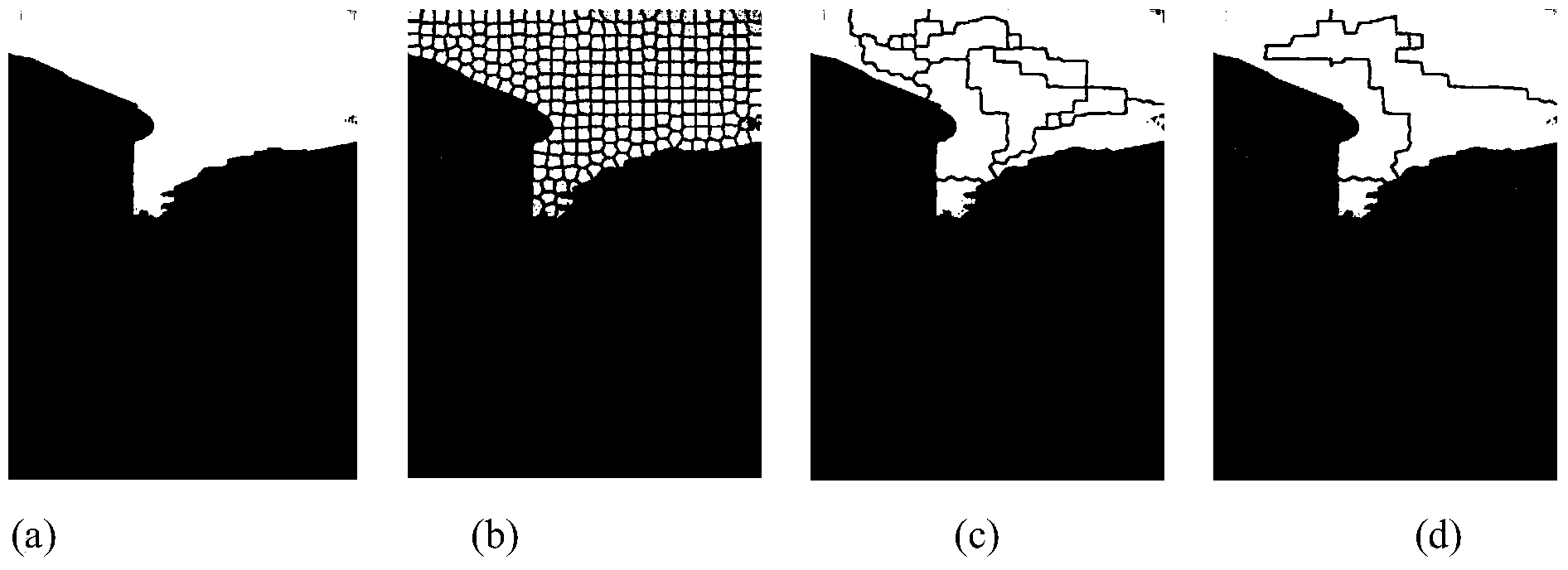
[0036] (1) First, perform superpixel image segmentation based on pixel color and spatial position on the image to form a superpixel image with a certain density;

[0037] (2) By using the general clustering algorithm based on superpixel color space distance, texture feature vector distance and geometric adjacency relationship, the superpixel image is reduced to a large block cluster image below 10%;

[0038] (3) The gravitational field fuzzy distribution density function representing the sky, ground and facade objects are multiplied by the pixels of these large blocks, and the expected value of these large blocks is obtained, thereby generating the preliminary classification of the sky, ground an...


PUM


Abstract

The invention discloses a method for identifying monocular visual spaces in terrestrial gravitational field environments. The method is characterized by comprising steps of firstly, dividing ultra-pixels of images on the basis of CIELAB color space values L, a and b of pixels and coordinate values x and y of the pixels to generate ultra-pixel images; secondly, reducing dimensions of the divided and formed ultra-pixel images by a general clustering algorithm on the basis of vector distances from color characteristics to feature characteristics of the ultra-pixels and adjacency relations, and generating large image blocks; thirdly, respectively multiplying pixels of the obtained large image blocks by fuzzy distribution density functions of gravitational fields and solving expected values of the large image blocks so as to initially classify the sky, the ground and vertical objects; fourthly, extracting classified images of the sky, the ground and the vertical objects by the aid of single-layer wavelet sampling and characteristics of the Manhattan direction; fifthly, generating spatial depth perception images on the basis of wavelet imaging models and ground linear perspective information. The fuzzy distribution density functions of the gravitational fields represent the sky, the ground and the vertical objects. The method has the advantages of simplicity, feasibility, high resolution and wide application range.

Description

technical field [0001] The present invention relates to an image processing method, especially an image processing method that can be widely used in fields such as robot visual navigation, large-space target measurement, target tracking and positioning, and can improve spatial recognition. Monocular visual space recognition method in the environment of gravity field. Background technique [0002] Understanding 3D spatial structure as a basic problem of machine vision has been paid attention to and studied for a long time. Early research work focused on stereo vision or obtaining 3D clues through the movement of the viewing angle. In recent years, many researchers have focused on reconstructing 3D spatial structures from monocular vision images. At present, most monocular vision 3D spatial recognition methods use supervised machine learning methods, such as: Markov Random Fields (MRFs ), Conditional Probability Random Fields (CRFs), and Dynamic Bayesian Networks (DBN), etc. ...

Claims


Application Information

Patent Timeline
IPC IPC(8): G06K9/62
Inventor 郑李明崔兵兵
Owner NANJING YUANJUE INFORMATION & TECH CO NANJING
Why Eureka
Try Eureka