Laser radar road reconstruction and expansion exploratory survey design method

A laser radar, survey and design technology, applied in the direction of roads, roads, road repairs, etc., can solve problems such as the inability to meet the needs of road reconstruction and expansion construction, and achieve the effects of reducing manual field measurement, ensuring data quality, and assisting design and optimization

Active Publication Date: 2014-04-09
CCCC SECOND HIGHWAY CONSULTANTS CO LTD
View PDF3 Cites 68 Cited by
  • Summary
  • Abstract
  • Description
  • Claims
  • Application Information

AI Technical Summary

Problems solved by technology

[0010] Aiming at the problem that traditional surveying and design methods cannot meet the growing demand for road reconstruction and expansion construction, the purpose of this invention is to propose a survey and design method for road reconstruction and expansion that integrates vehicle-mounted and airborne laser radar measurements

Method used


Image

  • Laser radar road reconstruction and expansion exploratory survey design method
  • Laser radar road reconstruction and expansion exploratory survey design method
  • Laser radar road reconstruction and expansion exploratory survey design method

Examples


Embodiment 1

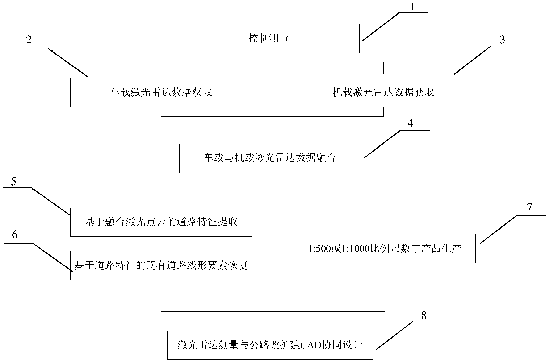
[0029] A laser radar road reconstruction and expansion survey and design method, more specifically, a method for road reconstruction and expansion survey and design that integrates vehicle-mounted and airborne laser radar measurement technologies. The flow chart is as follows figure 1 As shown, each step is described in detail as follows:

[0030] The first step, control measurement

[0031] 1. Design of achievement coordinate benchmark. The plane coordinate system of the achievement is the 2000 National Geodetic Coordinate System or the 1980 Xi’an Coordinate System or the 1954 Beijing Coordinate System or the local coordinate system. Gaussian projection is adopted. The selection of the central meridian and the projection plane should make the projected length deformation value in the survey area less than 25mm / km. The elevation datum of the achievement is the 1985 national elevation datum or other elevation datums.

[0032] 2. Basic control measurement. Along the direction...


PUM


Abstract

The invention discloses a laser radar road reconstruction and expansion exploratory survey design method. The method comprises the steps of A designing a result coordinate benchmark, measuring basic control and measuring pavement control points; B determining parameters including the data density, acquisition route and the like, and acquiring vehicle laser radar data along a main road and a ramp; C determining parameters including the data density, flight design and the like, and acquiring airborne laser radar data according to a designed flight strip; D realizing laser radar data fusion by refining laser point cloud plane coordinates and elevation coordinates and refining track line data; E acquiring characteristics of road traffic lane lines by using point cloud intensity information, and realizing extraction of characteristic lines of road pavements, protection and the like by adopting a method of projecting three-dimensional point clouds to a two-dimensional plane; F recovering planar elements and longitudinal surface elements of an existing road; G producing a DEM (digital elevation model), a DOM (digital orthophoto map) and a DLG (digital line graphic); H collaboratively designing laser radar measurement and road reconstruction and expansion CAD (computer-aided design), designing flat, longitudinal and transverse cross sections of a road, comparing and selecting schemes, and outputting final design drawings and charts.

Description

technical field [0001] The present invention relates to the technical field of highway survey and design, in particular to a road reconstruction and expansion survey and design method that integrates vehicle-mounted and airborne laser radar measurements. Engineering scheme design and optimization, the accuracy meets the requirements of road reconstruction and expansion measurement and construction drawing design. Background technique [0002] Accurate acquisition of 3D information such as roads and their auxiliary structures is an important prerequisite for road reconstruction and expansion. For road reconstruction and expansion projects, in order to maximize the use of existing roads, it is first necessary to accurately restore the linear elements of the existing roads; in addition, in order to achieve accurate splicing of bridges, roadbeds, etc., compared with new road projects, its impact on measurement accuracy There are also higher requirements. At present, the method...

Claims


Application Information

Patent Timeline
Patent Type & Authority Applications(China)
IPC IPC(8): E01C1/00E01C23/01
Inventor 陈楚江明洋余绍淮王丽园张霄余飞
Owner CCCC SECOND HIGHWAY CONSULTANTS CO LTD
Why Eureka
Try Eureka