Parallel drawing method for complicated geographic information

A geographic information and complex technology, applied in the field of parallel rendering of complex geographic information, can solve the problems of high management overhead, insufficient support for complex graphics rendering, low graphics rendering efficiency, etc., to avoid high overhead and improve program data processing capabilities.

Active Publication Date: 2014-04-09
四川九洲投资控股集团有限公司
View PDF2 Cites 10 Cited by
  • Summary
  • Abstract
  • Description
  • Claims
  • Application Information

AI Technical Summary

Problems solved by technology

[0003] The purpose of the present invention is to: aim at the problems existing in the prior art, provide a kind of parallel drawing method of complex geographical information, solve the defect such as traditional GIS platform element management expense is large, graphics drawing efficiency is low, and support for complex drawing is insufficient, puts forward Separate the static elements and dynamic elements of complex geographic information, use the concept of parallel processing to group the dynamic elements according to the spatial height, each sub-node is responsible for the calculation and drawing of dynamic elements within a certain height range, and finally the graphics generated by each sub-node After integration, it will be refreshed to the foreground at one time to display complete geographic information, while the actual graphics drawing uses mature drawing tools such as GDI+, opengl, etc., to prevent developers from having an in-depth understanding of the proprietary drawing methods of related GIS platforms and reduce the difficulty of development , while utilizing the high-efficiency characteristics of mature drawing tools such as GDI+ and opengl to improve the display efficiency of geographical scenes

Method used


Image

  • Parallel drawing method for complicated geographic information
  • Parallel drawing method for complicated geographic information

Examples


Embodiment

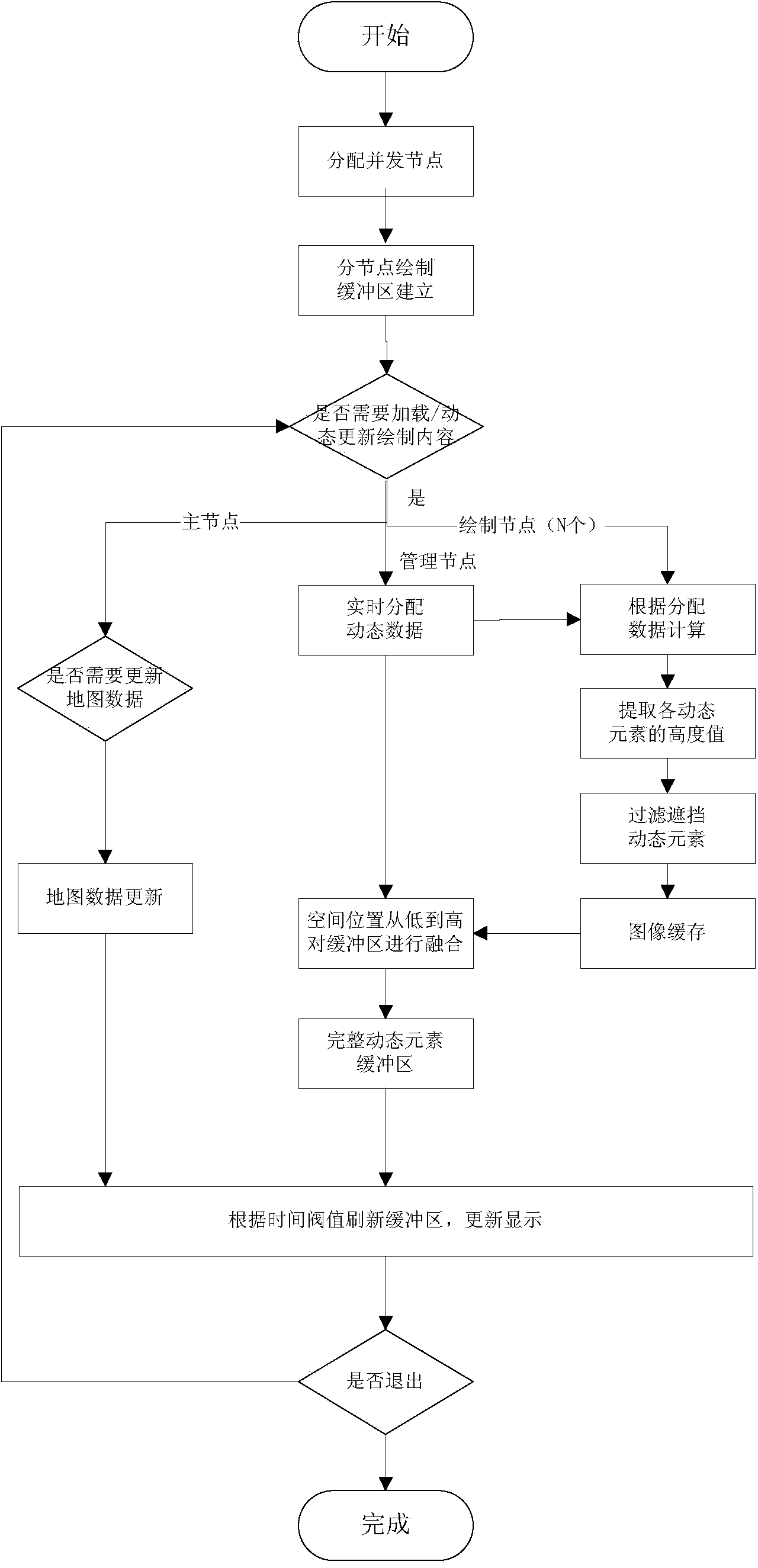
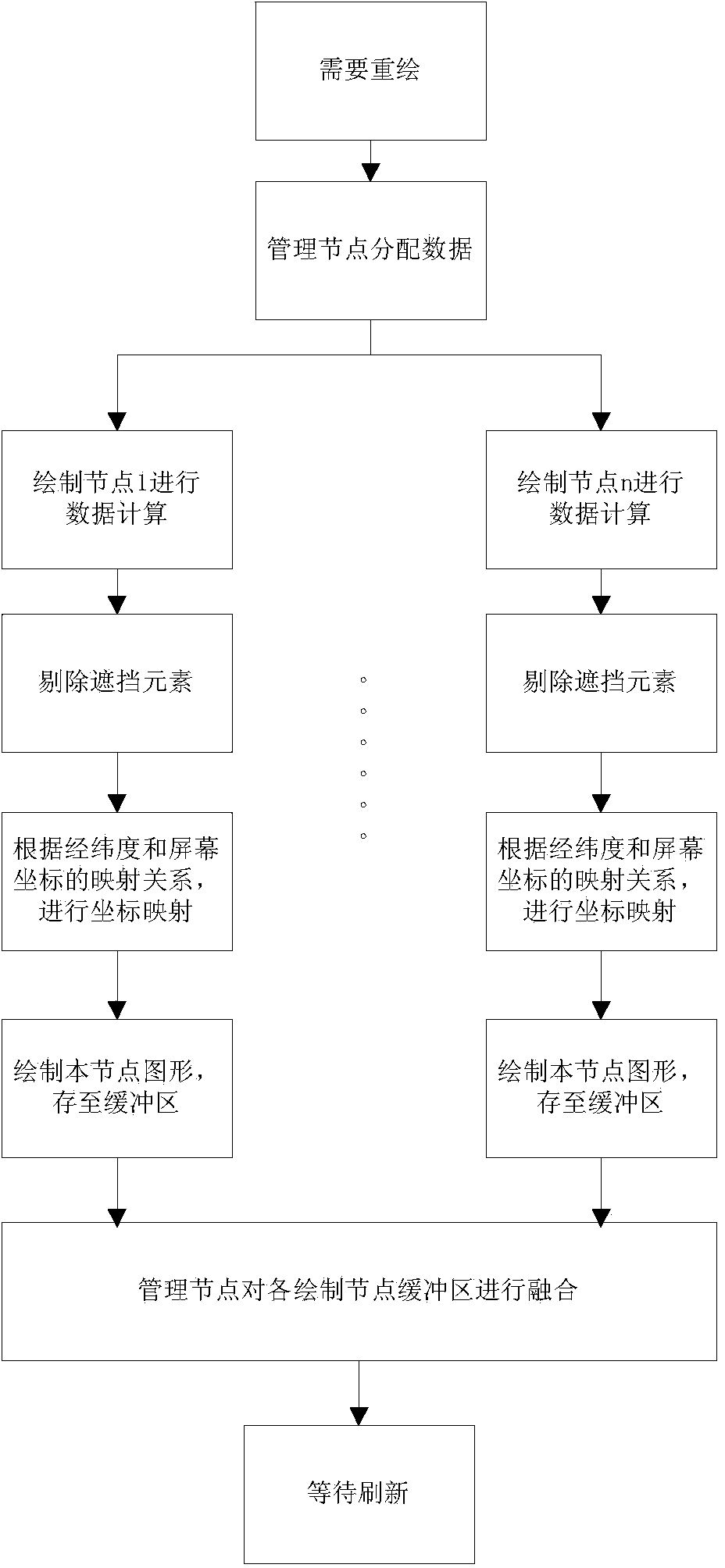
[0026] This method separates the static elements and dynamic elements of complex geographic information, uses the concept of parallel processing to group the dynamic elements according to the spatial height, each sub-node is responsible for the calculation and drawing of the dynamic elements within a certain height range, and finally generates each sub-node The graphics are fused and refreshed to the foreground at one time to display complete geographic information, while the actual drawing operation uses mature drawing tools such as GDI+ and opengl, allowing designers to meet the drawing needs while combining existing scenes for complex The flexible drawing of geographic information not only avoids developers from understanding the cumbersome drawing methods exclusive to different GIS platforms, but also broadens the application fields of traditional GIS platforms and improves the diversity of GIS platform mapping.

[0027] Process flow of the present invention such as figure...


PUM


Abstract

The invention provides a parallel drawing method for complicated geographic information. The method comprises the steps that the complicated geographic information to be drawn is divided into static elements and dynamic elements, the dynamic elements are grouped according to the space height, and the number of concurrence nodes is determined; according to the range to be displayed and the display screen resolution, each concurrence node sets up a drawing buffer in a memory, and the complicated geographic information to be drawn is cached in the drawing buffer; the static elements draw a static vector map through a GIS platform of a host node, and the dynamic elements carry out real-time parallel computing and cache dynamic geographic data in the background through partial nodes; the host node loads the drawing buffer in the foreground according to a certain time step to refresh the current display, and then dynamic drawing of the complicated geographic information is finished. The dynamic elements are processed and computed in a parallel processing mode, the computing power of CPU and a GPU of a computer is fully utilized, the data processing capacity is greatly improved, and therefore the drawing efficiency is improved.

Description

technical field [0001] The invention relates to the field of geographic information image processing, in particular to a parallel rendering method for complex geographic information. Background technique [0002] With the continuous development and application of information technology, the display and processing of more and more large-scale geographic information depends on the GIS platform, and the application of the GIS platform is also more diversified. From a single traditional function such as displaying electronic maps and generating statistical charts, Gradually develop into multi-fields and disciplines such as intelligent transportation, smart city, war deduction, etc. At the same time, the drawing requirements of traditional GIS platforms are more complicated and diversified. Traditional GIS platforms can no longer meet the drawing needs of complex geographic information in special scenarios . Although some excellent GIS platforms (such as ArcGIS, etc.) solve the ...

Claims


Application Information

Patent Timeline
Patent Type & Authority Applications(China)
IPC IPC(8): G06F17/50
Inventor 李硕张谷林周龙萍徐政任丽萍
Owner 四川九洲投资控股集团有限公司
Why Eureka
Try Eureka