Method of measuring level elevation difference based on geoid model

A geoid, model measurement technology, applied in the field of surveying and mapping, can solve the problems of loss of high-frequency information, time and space reach, increase project cycle and production cost, etc., to achieve the effect of high efficiency and low work intensity

Active Publication Date: 2014-04-16
HUBEI PROVINCIAL WATER RESOURCES & HYDROPOWER PLANNING SURVEY & DESIGN INST
View PDF3 Cites 10 Cited by
  • Summary
  • Abstract
  • Description
  • Claims
  • Application Information

AI Technical Summary

Problems solved by technology

[0009] The high-resolution gravity quasi-geoid determined by the gravity field theory contains systematic deviations due to the influence of ground gravity data errors and distribution density. Although the accuracy of GPS / leveling is very high, it is difficult to achieve due to the limitation of leveling methods. To achieve a certain density requirement in time and space, therefore, how to synthesize these two similar geoids to obtain a high-precision regional geoid that eliminates systematic errors has different processing methods. In this method, the high-resolution but low-precision gravity quasi-geoid is fitted to the high-precision but small number of GPS (similar) geoid, so as to eliminate the systematic deviation of the gravity quasi-geoid, and the gravity quasi-geoid The fitting of the geoid and the GPS / level quasi-geoid can better eliminate the systematic deviation between the two and improve the accuracy of the quasi-geoid, but there are still some shortcomings in this method:
[0010] (1) The systematic deviation between the gravity quasi-geoid and the GPS / horizontal quasi-geoid is very complicated, and it is impossible to replace it with some kind of mathematical surface. This kind of surface fitting obviously has a large error;
[0011] (2) Because the GPS / benchmarks are generally sparse, the data used for surface fitting is less, and the complex quasi-geoid cannot be accurately represented, so it is difficult to achieve a good fitting effect. To ensure the fitting accuracy, it is necessary to Deploying dense GPS / leveling points will inevitably lead to an excessive increase in the leveling workload, increase the labor intensity in the field, and increase the project cycle and production costs;
[0012] (3) The fitting surface is a smooth mathematical surface, which will cause some high-frequency information to be lost during the fitting process.

Method used


Image

  • Method of measuring level elevation difference based on geoid model
  • Method of measuring level elevation difference based on geoid model
  • Method of measuring level elevation difference based on geoid model

Examples


Embodiment

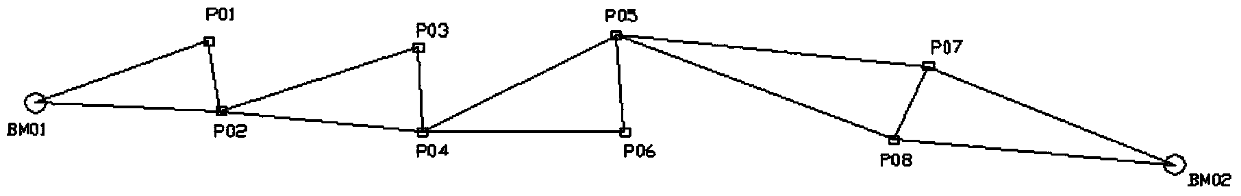
[0067] Example: For a water conservancy project, the length of the leveling line is 75.8km, and 13 control points are set, among which HBJT02 and HBJT24 are known elevation points, and GNSS static positioning measurement is used to jointly measure each control point, and EGM2008 global geoid is used The model calculates the height anomaly according to the above method, and calculates the converted level difference according to the above method. In order to verify the accuracy of this method, each control point is jointly measured with the third level level, and the converted level difference is compared with the third level level difference. From the following It can be seen from the table that the height difference is within the tolerance.

[0068]

[0069]

[0070] Table 1

[0071]

[0072] Table 2

[0073] Elevation closure difference / m

0.0405

Four grade tolerance / m

0.174

[0074] table 3

[0075] According to statistics, within a ...


PUM


Abstract

The invention discloses a method of measuring a level elevation difference based on a geoid model. The method comprises the steps: calculating a height anomaly difference of two adjacent control points by adopting the geoid model, so as to obtain a geodetic height difference of the two adjacent control points by virtue of the measurement of a GNSS (Global Navigation Satellite System), carrying out subtraction on the height anomaly difference and the geodetic height difference to be converted to the level elevation difference, and calculating an elevation of each control point. The method can be applied to multiple terrains including plains, hills, mountain areas and the like. With the adoption of the method, an interval between every two adjacent control points can reach 5-8km, the working efficiency can be improved by 6-10 times, and the third class or fourth class leveling accuracy can be realized; in addition, as the only heights of the two control points at the head and tail ends are needed, and the geometrical leveling is not needed, the method has the characteristics of low working intensity and high efficiency.

Description

technical field [0001] The invention relates to the technical field of surveying and mapping, in particular to a method for measuring level differences based on a geoid model. Background technique [0002] In the prior art, the measurement of the level difference is generally carried out by geometric leveling; the geometric level refers to the method of measuring the height difference between two points on the ground with a level and a leveling rod. Place a level between two points on the ground, observe the leveling rod erected on the two points, and calculate the height difference between the two points according to the reading on the ruler. Usually starting from the leveling origin or any known elevation point, the elevation of each point is measured station by station along the selected leveling route, and the distance of one station is 20-200m. [0003] Using the geometric leveling method to measure the level difference has high work intensity and low efficiency, which...

Claims


Application Information

Patent Timeline
Patent Type & Authority Applications(China)
IPC IPC(8): G01C5/00
CPCG01C5/00
Inventor 邸国辉
Owner HUBEI PROVINCIAL WATER RESOURCES & HYDROPOWER PLANNING SURVEY & DESIGN INST
Why Eureka
Try Eureka