Ship's inertial navigation system (SINS)/Doppler velocity log (DVL)/global positioning system (GPS)-based autonomous underwater vehicle (AUV) combined navigation system

An integrated navigation system and GPS receiver technology, applied in the field of AUV integrated navigation system, can solve the problems of inaccurate precision filtering model, inaccurate SINS system navigation and positioning error, Kalman filtering accuracy decline, etc., so as to overcome the inaccurate filtering model. Effect

Active Publication Date: 2014-04-23
SOUTHEAST UNIV
View PDF6 Cites 30 Cited by
  • Summary
  • Abstract
  • Description
  • Claims
  • Application Information

AI Technical Summary

Problems solved by technology

[0010] Purpose of the invention: In order to overcome the deficiencies in the prior art, the present invention provides an AUV integrated navigation system based on SINS / DVL / GPS, which introduces DVL speed measurement information and GPS position information into the AUV integrated system to assist SINS in navigation and tracking Positioning; the system integrates the information of multiple sub-navigation systems, and overcomes the susceptibility of the AUV navigation system to the environment, the navigation and positioning errors of the SINS system accumulate over time and fail to meet the accuracy requirements, and the filtering model is inaccurate or the system is interfered by colored noise. Defects that cause Kalman filtering accuracy to decrease

Method used


Image

  • Ship's inertial navigation system (SINS)/Doppler velocity log (DVL)/global positioning system (GPS)-based autonomous underwater vehicle (AUV) combined navigation system
  • Ship's inertial navigation system (SINS)/Doppler velocity log (DVL)/global positioning system (GPS)-based autonomous underwater vehicle (AUV) combined navigation system
  • Ship's inertial navigation system (SINS)/Doppler velocity log (DVL)/global positioning system (GPS)-based autonomous underwater vehicle (AUV) combined navigation system

Examples


Embodiment Construction

[0035] The present invention will be further described below in conjunction with the accompanying drawings.

[0036] Design principle description

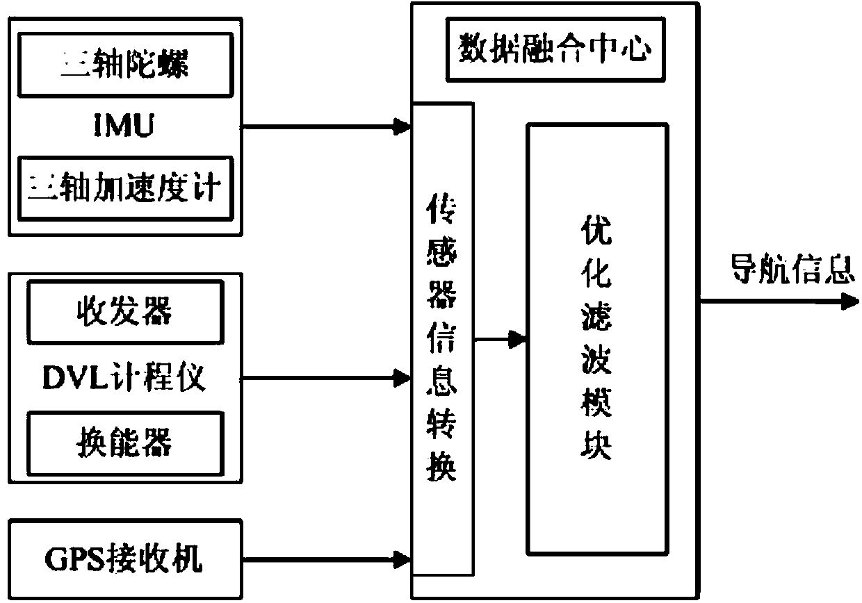
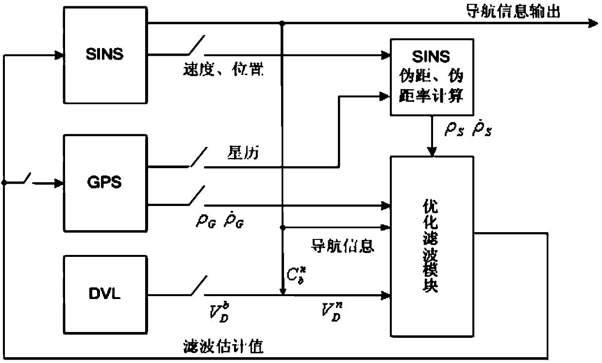
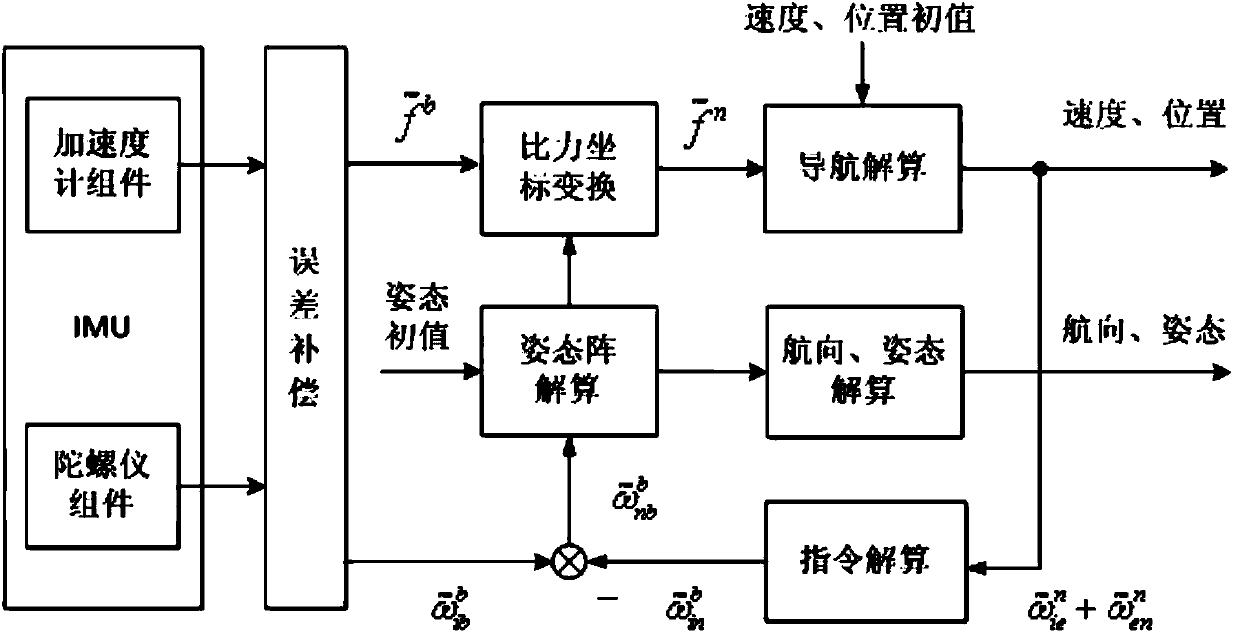
[0037] AUV is an important tool for exploring, developing and utilizing marine environmental resources, and also plays an important role in marine military applications. Because of its remoteness, concealment and complex underwater environment, integrated navigation is often used to navigate and position AUV. The SINS system has autonomous navigation capability and is not affected by the environment, carrier maneuvering and radio interference. It can continuously provide navigation and positioning information such as carrier position, speed and attitude. Its data update frequency is fast, and it has a high relative precision. However, as the working time of the system prolongs, the navigation error of the SINS system will accumulate and increase. At this time, it is necessary to use the observation information of external sensors...


PUM


Abstract

The invention discloses a ship's inertial navigation system (SINS)/Doppler velocity log (DVL)/global positioning system (GPS)-based autonomous underwater vehicle (AUV) combined navigation system, which comprises an SINS, a GPS receiver, a DVL and a data fusion center, wherein the SINS, the GPS receiver, the DVL and the data fusion center are arranged on an AUV; when the AUV is positioned on the water surface, an optimized filter module carries out filtering fusion calculation by combining navigation information of the SINS, a pseudo-range and a pseudo-range rate corresponding to the SINS and available ephemeris data output by the GPS receiver to obtain correction information; when the AUV is positioned underwater, the optimized filter module carries out filtering fusion calculation by combining the navigation information output by the SINS and three-dimensional navigational speed information output by the DVL to obtain correction information. The navigational positioning accuracy and the robustness of the system are improved, and the system realizes an uninterrupted high-accuracy underwater and water surface carrier navigating and tracking function.

Description

technical field [0001] The invention relates to an AUV combined navigation system based on SINS / DVL / GPS, which can be used for navigation, tracking and positioning of underwater submersibles and surface vehicles. Background technique [0002] AUV (Autonomous Underwater Vehicle) is an important tool for exploring, developing and utilizing marine environmental resources, and also plays an important role in marine military applications. Because of its long-distance, concealment and autonomy, the navigation problem of AUV is still one of the main technical challenges. Due to the complex underwater environment, the integrated navigation method is often used to navigate and position the AUV, and the filter design of the integrated navigation system is the key to ensure the navigation accuracy. At present, the navigation and positioning accuracy of conventional AUVs can reach about <0.8nmile / h, which meets the accuracy requirements of AUV navigation and positioning to a certain...

Claims


Application Information

Patent Timeline
Patent Type & Authority Applications(China)
IPC IPC(8): G01S19/48
CPCG01C21/165G01S19/48G01S19/49
Inventor 程向红许立平王磊朱倚娴冯骥韩旭
Owner SOUTHEAST UNIV
Why Eureka
Try Eureka