Drivable region detection method based on laser radar

A technology of laser radar and driving area, which is applied in the field of traffic scene perception, can solve the problems of strict external environment requirements, difficult data processing, and inability to accurately detect drivable areas, etc., and achieve good real-time and ease-of-use effects

Inactive Publication Date: 2014-04-30
XI AN JIAOTONG UNIV
View PDF5 Cites 42 Cited by
  • Summary
  • Abstract
  • Description
  • Claims
  • Application Information

AI Technical Summary

Problems solved by technology

However, one of the most important shortcomings of visual technology is the relatively strict requirements for the external environment.
For situations such as shadows in the environment, complex driving environment, missing roadside markings (or signs), poor lighting, low visibility, or bad weather...

Method used


Image

  • Drivable region detection method based on laser radar
  • Drivable region detection method based on laser radar
  • Drivable region detection method based on laser radar

Examples


Embodiment Construction

[0049] The present invention will be described in detail below in conjunction with the accompanying drawings.

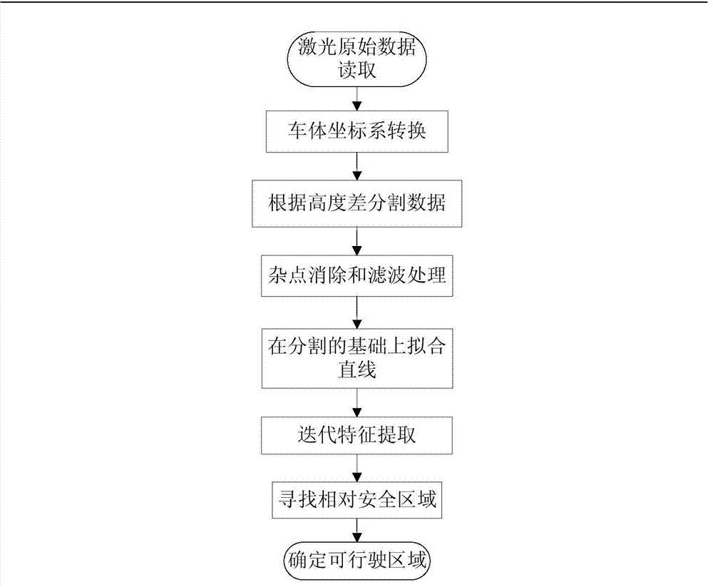
[0050] In order to be able to perceive the surrounding traffic scene in a real-time and stable manner, the present invention provides a drivable area detection method based on lidar data in an actual traffic scene, which specifically includes lidar calibration, data segmentation, noise elimination and data filtering, and feature extraction And determine the five parts of the drivable area, such as image 3 shown. The method is specifically carried out in the following steps:

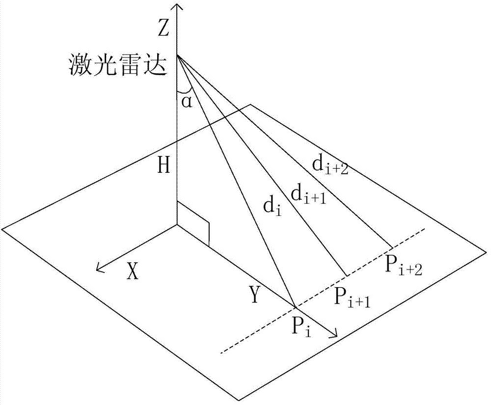
[0051] Step 1.1: In order to realize the function of detecting the driving area of ​​the lidar, it is necessary to install the lidar directly in front of the front of the car, and scan obliquely downward to ensure that it intersects with the road.

[0052] At this point defined as figure 2 In the shown local space Cartesian coordinate system, measure the installation height H of the laser r...


PUM


Abstract

The invention discloses a drivable region detection method based on a laser radar. The method includes the steps that the laser radar is used for scanning an actual traffic scene, and flat and rugged conditions of a current scene are obtained; scanning data returned by the laser radar are divided into a plurality of fragments through the height variation condition, an iterative linear fitting algorithm is used for extracting appropriate linear features from all the segments, flat regions are found out from the fragments which meet constraint conditions, and drivable regions are determined from the flat regions according to the requirements of the vehicle width; if a multi-line laser exists, corresponding drivable regions can be determined from the flat regions reflected by the line data on the basis of a drivable region of former line data from the near to the distant. According to the method, detection of the drivable regions in the actual traffic scene can be effectively completed, safe passage regions of an automobile are described accurately, and the method has good real-time performance, usability and robustness.

Description

technical field [0001] The invention belongs to the field of traffic scene perception in unmanned vehicle technology, and specifically relates to a method of using laser radar as a data source to complete the perception of drivable areas in actual traffic scenes. Background technique [0002] In recent years, with the rapid development of the automobile industry, traffic accidents have become a global problem. It is estimated that the number of deaths and injuries in traffic accidents in the world exceeds more than 500,000 people every year. Born for human driving applications. In order to perceive environmental information in real time and reliably, driverless cars are equipped with various active and passive sensors, including cameras, lidar, millimeter-wave radar and GPS. Drivable area detection is one of the key parts of driverless technology. . Vision technology has long been the research direction of choice for researchers because of its high information content, low...

Claims


Application Information

Patent Timeline
IPC IPC(8): G01S17/88
CPCG01S7/4802G01S17/88
Inventor 薛建儒张春家杜少毅戚晓林王迪程皓洁
Owner XI AN JIAOTONG UNIV
Why Eureka
Try Eureka