

Single satellite image-oriented self-acquired triangular element height calculation method
A satellite image and altitude calculation technology, which is applied in the direction of measuring angle, altitude/horizontal measurement, measuring device, etc., to achieve good results in altitude calculation
- Summary
- Abstract
- Description
- Claims
- Application Information
AI Technical Summary
Problems solved by technology
Method used
Image

Examples
Embodiment 1
[0094] Embodiment 1: Taking the satellite image of the area near the Shanghai World Financial Center Building taken on October 4, 2009 as an example, calculate the height of the World Financial Center Building.
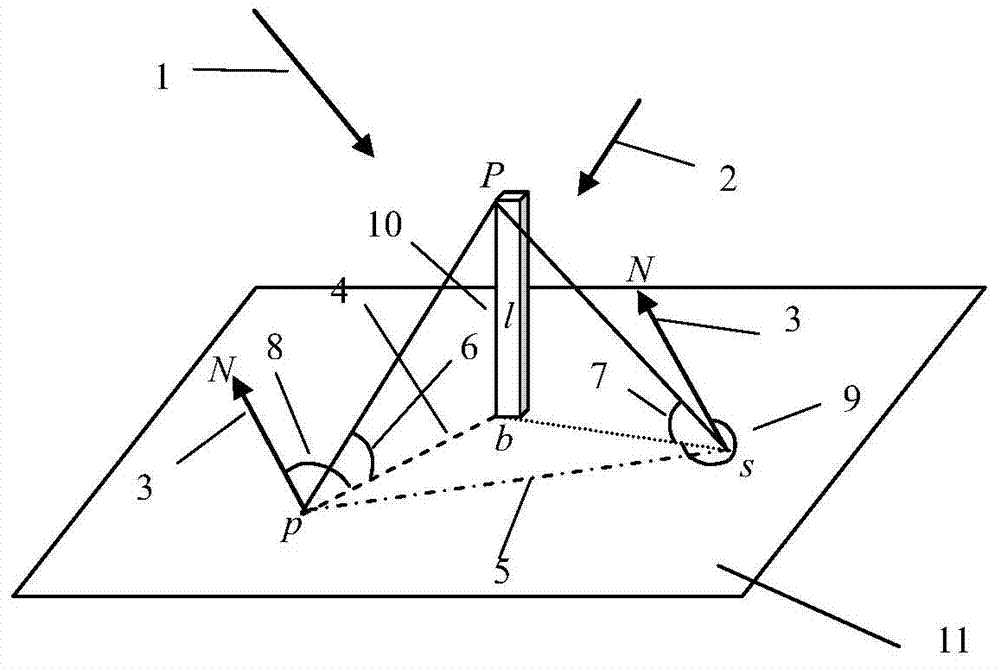
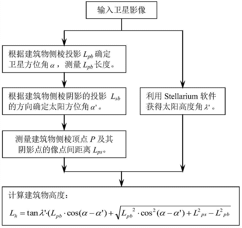
[0095] Measure the angle between the side edge of the building and the true north direction in the image to obtain the satellite azimuth angle α=148.50° when the image is taken.
[0096] The angle between the direction of the side edge shadow of the building in the image and the true north direction is measured to obtain the sun azimuth α'=154.23°.
[0097] The scale information provided by the satellite remote sensing image itself is 0.498m / pixel:
[0098] The length of the side edge of the building in the measurement image is 223 pixels, so the projected length of the building is L pb for:
[0099] L pb =0.498×223=111.054m
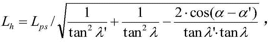
[0100] The distance between the image points of the side edge vertex P and its shadow point in the measured image is 576 pixels, so:
[01...
Embodiment 2
[0106] Embodiment 2: Taking the satellite image of the area near the Beijing New Poly Building taken on June 23, 2009 as an example, calculate the height of the New Poly Building.
[0107] The angle between the side edge of the building and the true north direction in the image is measured to obtain the satellite azimuth angle α=263.93° when the image is taken.
[0108] The angle between the direction of the side edge shadow of the building in the image and the true north direction is measured to obtain the sun azimuth α'=142.03°.
[0109] The scale information provided by the satellite remote sensing image itself is 0.222m / pixel:
[0110] The length of the side edge of the building in the measurement image is 196 pixels, so the projected length of the building is L pb for:
[0111] L pb =0.222×196=43.512m
[0112] The distance between the image points of the side edge vertex P and its shadow point in the measured image is 326 pixels, so:
[0113] L ps =0.222×326=72.372m...
Embodiment 3
[0118] Embodiment 3: Take the satellite image of the area near the Beijing Water Cube Swimming Complex taken on October 27, 2010 as an example to calculate the height of the Water Cube Swimming Complex.
[0119] Measure the angle between the side edge of the building and the true north direction in the image to obtain the satellite azimuth angle α=10.11° when the image is taken.
[0120] The angle between the direction of the side edge shadow of the building in the image and the true north direction is measured to obtain the sun azimuth α'=164.58°.
[0121] The scale information provided by the satellite remote sensing image itself is 0.234m / pixel:
[0122] The length of the side edge of the building in the measurement image is 73 pixels, so the projected length of the building is L pb for:
[0123] L pb =0.234×73=17.082m
[0124] The distance between the image points of the side edge vertex P and its shadow point in the measured image is 252 pixels, so:
[0125] L ps =0...
PUM
| Property | Measurement | Unit |
|---|---|---|
| Height | aaaaa | aaaaa |
| Height | aaaaa | aaaaa |
| Height | aaaaa | aaaaa |
Abstract
Description
Claims
Application Information