Telemetering method for quick tidal wetland terrain measurement

A technology of remote sensing and tidal flats, applied in photogrammetry/video metrology, measuring devices, height/level measurement, etc., can solve the problem of unintegrated synchronous water level observation system, which is not enough to develop into an operable tidal flat terrain monitoring method system , large terrain errors, etc.

Inactive Publication Date: 2014-05-14
HOHAI UNIV
View PDF1 Cites 19 Cited by
  • Summary
  • Abstract
  • Description
  • Claims
  • Application Information

AI Technical Summary

Problems solved by technology

Predecessors often use hydrodynamic models or measured cross-section data to assign water edge elevations. For large areas of tidal flat areas that lack underwater terrain data, the accuracy of hydrodynamic model simulation is not high, while artificially measured cross-sections often It cannot meet the needs of large-scale assignment, so the terrain

Method used


Image

  • Telemetering method for quick tidal wetland terrain measurement
  • Telemetering method for quick tidal wetland terrain measurement

Examples


Embodiment Construction

[0019] Below in conjunction with accompanying drawing, technical scheme of the present invention is described in further detail:

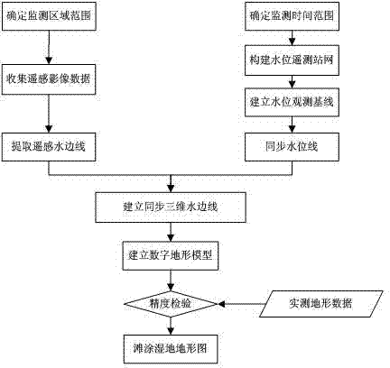
[0020] Such as figure 1 As shown, a remote sensing and telemetry method for rapid survey of tidal flat topography includes the following steps:

[0021] Step 1, determine the monitoring scope and monitoring time range of tidal flat wetlands and related waters;

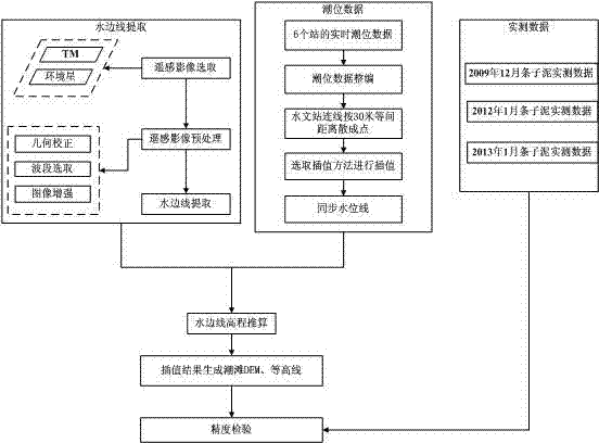
[0022] Step 2: Establish more than two water level telemetering stations in the monitoring area, and at the same time, according to the hydraulic connection characteristics of each water area, build a real-time monitoring water level telemetering station network and water level observation baseline along the longitudinal direction of the monitoring area, and extract observations at different times on the water level observation baseline Water level line; the water level observation baseline is formed by the connecting broken line of more than two water level telemetry stations, and the ob...


PUM


Abstract

The invention discloses a telemetering method for quick tidal wetland terrain measurement. The telemetering method comprises the steps of building more than two water level telemetering stations in a measured tidal wetland and relevant water domains, constructing a water level observation base line and a water level telemetering station network along the longitudinal direction of the measured water domain so as to perform real-time water level monitoring, and constructing observation water level lines at different time synchronous with an acquired telemetering image; acquiring multi-source and multi-temporal satellite telemetering image data of the monitored region, and extracting telemetering flowage lines at different water levels; performing synchronous water level assignment on each flowage line point on each telemetering flowage line, and constructing three-dimensional telemetering flowage lines; and constructing a tidal flat digital terrain model on the basis of a series of the three-dimensional telemetering flowage lines to finally finish the tidal wetland terrain map of a monitored region. According to the tidal terrain innovation method on the basis of satellite telemetering and a hydrologic network, the difficulty in conventional manual measurement on foot, shipborne radar field measurement and modern aerial radar measurement is overcome; the height accuracy of terrain measurement reaches the centimeter level.

Description

technical field [0001] The invention relates to a topographic measurement method, in particular to a remote sensing and telemetry method for rapid topographic measurement of tidal flats and wetlands. Background technique [0002] The traditional topographic survey method based on theodolite and modern total station belongs to the field survey method, and its technical route for regional topographic survey is a topographic survey method from point to line and then to surface. The field measurement operation conditions are difficult, the efficiency is low, and the financial resources are consumed. [0003] Underwater topographic survey is mainly carried out by ship-borne test instrument. Tidal flats are widely distributed in the coastal areas of rivers, lakes, and tidal flat topography is a long-standing problem. The ship-borne measurement method of underwater topography is limited by the need for sufficient water depth (draft) for ships to sail, and the measurement ship can...

Claims


Application Information

Patent Timeline
IPC IPC(8): G01C11/00
CPCG01C11/28G01C5/00
Inventor 丁贤荣夏娟康彦彦茅志兵孙玉龙葛小平
Owner HOHAI UNIV
Why Eureka
Try Eureka