Engineering geology informatization work system

A technology of engineering geology and geology, applied in image data processing, special data processing applications, instruments, etc., can solve problems such as large amount of data, difficulties in data management and data sharing, restricting the benefit of data resources, etc., and achieve the effect of improving efficiency.

Active Publication Date: 2014-05-21
长江三峡勘测研究院有限公司(武汉)
View PDF2 Cites 13 Cited by
  • Summary
  • Abstract
  • Description
  • Claims
  • Application Information

AI Technical Summary

Problems solved by technology

Field data collection mainly includes geological point positioning, geological point description, written records, sketches, photography, sampling, etc. The amount of data is large. In the traditional geological survey mode, all data collection is mainly done manually, and all Most of the field data information is recorded in the form of paper media, which

Method used


Image

  • Engineering geology informatization work system

Examples


Embodiment Construction

[0031] In order to make the object, technical solution and advantages of the present invention more clear, the present invention will be further described in detail below in conjunction with the examples. It should be understood that the specific embodiments described here are only used to explain the present invention, not to limit the present invention.

[0032] Further illustrate the present invention below in conjunction with accompanying drawing and embodiment.

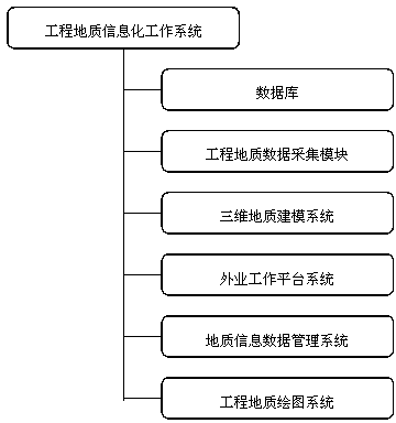
[0033] Such as figure 1 As shown, an engineering geological information work system includes:

[0034] Engineering geological data acquisition module; used to read the monitoring data of on-site buried monitors and receive field geological point data. The monitoring data includes earthquake monitoring, landslide monitoring, groundwater monitoring and other data. The geological point data information is mainly Including geological point coordinates, text descriptions and photos; the geological point coordinates...


PUM


Abstract

The invention relates to an engineering geology informatization work system which comprises an engineering geological data acquisition module, a database, a field process platform system, a geological information data management system, a three-dimensional geological modeling system and an engineering geology drafting system. The database is used for storing geological data acquired by the engineering geological data acquisition module. The field process platform system is used for field geological survey work and drafting of a material graph. The geological information data management system is used for the management and application of the geological data in the database. The three-dimensional geological modeling system is used for generating a geological body three-dimensional model according to the geological data acquired by the engineering geological data acquisition module. The engineering geology drafting system is used for generating a standard geological map meeting the requirements of various regulations and norms according to the geological data with a topographic map and an orthophoto map as the background. The engineering geology informatization work system provides a complete solution for engineering geological investigation work, and the functions of the informatization work system can be expanded. By the application of the system, revolutionary change can be brought to the engineering geological investigation work, and the efficiency of the engineering geological investigation work is greatly improved.

Description

technical field [0001] [The present invention relates to the field of engineering technology, in particular to an engineering geology informatization work system. [0002] Background technique [0003] The engineering geological workflow is a process starting from data collection and field data acquisition, to internal data collation and processing, and then to the preparation of charts and reports. The types of data information involved in the geological survey of water conservancy and hydropower projects are various, and have the characteristics of information systems such as multiple data sources, multiple types, multiple levels, and huge data volumes. Field data collection mainly includes geological point positioning, geological point description, written records, sketches, photography, sampling, etc. The amount of data is large. In the traditional geological survey mode, all data collection is mainly done manually, and all Most of the field data information is recorde...

Claims


Application Information

Patent Timeline
IPC IPC(8): G06F17/50G06T17/05
Inventor 满作武陈又华杨红廖立兵段建肖潘金鹤秦双乐叶圣生王家祥赵明华王团乐
Owner 长江三峡勘测研究院有限公司(武汉)
Why Eureka
Try Eureka