LiDAR point cloud data overwater bridge extraction method based on irregular triangulated network

A point cloud data and extraction method technology, applied in the field of remote sensing application research, can solve the problems of multiple parameter settings and low extraction method efficiency

Inactive Publication Date: 2014-05-21
XIDIAN UNIV
View PDF2 Cites 8 Cited by
  • Summary
  • Abstract
  • Description
  • Claims
  • Application Information

AI Technical Summary

Problems solved by technology

[0006] Aiming at the shortcomings of the existing LiDAR point cloud data water bridge extraction method, such as low efficiency and many parameter settings, a water bridge extraction method based on irregular triangulation LiDAR point cloud data is proposed. This method makes full use of the absorption of laser points by water bodies. characteristics, triangulate the LiDAR point cloud data, detect

Method used


Image

  • LiDAR point cloud data overwater bridge extraction method based on irregular triangulated network
  • LiDAR point cloud data overwater bridge extraction method based on irregular triangulated network
  • LiDAR point cloud data overwater bridge extraction method based on irregular triangulated network

Examples


Embodiment Construction

[0061] refer to figure 1 , the LiDAR point cloud data water bridge extraction method based on irregular triangulation of the present invention, specifically comprises the following steps:

[0062] Step 1, read the original LiDAR point cloud data of the target area;

[0063] Step 2, remove gross error noise;

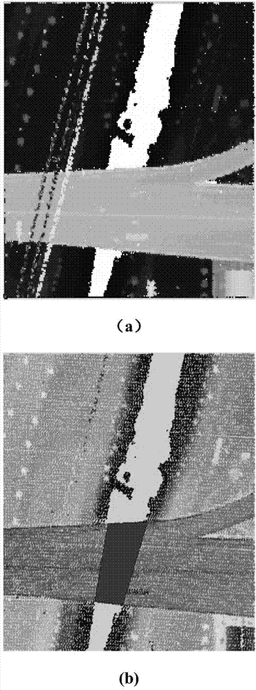
[0064] The original point cloud data will produce some gross error noise. In order to obtain accurate point cloud data, the gross error noise point must be eliminated first. The gross error noise point refers to the isolated noise point with no other points within the limited range. Its definition is as follows :

[0065] n=∑(|P i -P j |<σ)

[0066] Among them, P i Represents the XY coordinates of point i in the original LiDAR point cloud data, n represents the coordinate P in the original LiDAR point cloud data i The number of points whose distance is less than σ, where the value range of n is 0-3, and the value range of σ is 10-20m;

[0067] Step 3, build an irr...


PUM


Abstract

The invention discloses a LiDAR point cloud data overwater bridge extraction method based on an irregular triangulated network. The method includes the steps: reading original LiDAR point cloud data of a target area; removing gross error noise; performing Delaunay triangulation for the LiDAR point cloud data to form the irregular triangulated network; calculating the narrow extent of all triangles; calculating an edge point elevation threshold value and separating a bridge edge point from a river edge point by taking the elevation threshold value as a dividing point to obtain a river edge point and bridge edge point elevation changing curve; further separating the river edge point and fitting a river bank edge curve; further separating the bridge edge point and fitting a bridge edge curve; solving bridge angle points, marking all obtained bridge angle points and extracting overwater bridges. By making full use of the laser point absorption characteristic of water bodies, the LiDAR point cloud data are triangulated to determine the water bodies, the bridge angle points are obtained by separating the river edge point from the bridge edge point, and one or a plurality of bridges positioned on the water bodies can be efficiently and accurately extracted.

Description

technical field [0001] The invention belongs to the field of remote sensing application research, and in particular relates to a method for extracting bridges over water from LiDAR point cloud data based on an irregular triangular network. Background technique [0002] The airborne LiDAR system can directly obtain 3D data on the ground, and has the advantages of high precision, high density, high efficiency and low cost. Using the massive data obtained quickly by it can obtain various image products that we need, so it plays an important role in modern surveying and mapping. increasingly important role. Bridges are important artificial buildings and transportation hubs, and it is of great significance to use LiDAR point cloud data for bridge target extraction. LiDAR point cloud data refers to the high-precision 3D point coordinates of the surface obtained by the airborne LiDAR system by transmitting and receiving laser pulses. [0003] The extraction of bridge targets is b...

Claims


Application Information

Patent Timeline
IPC IPC(8): G06K9/46G06K9/00
Inventor 苗启广宋建锋宣贺君张萌权义宁陈为胜许鹏飞刘如意
Owner XIDIAN UNIV
Why Eureka
Try Eureka