
Method for designing farmland leveling arbitrary slope reference plane

A technology of land leveling and design methods, which is applied in computing, special data processing applications, satellite radio beacon positioning systems, etc., and can solve problems that do not have universal applicability and design flexibility, and do not have mature equipment and technologies

Active Publication Date: 2014-06-11
CHINA AGRI UNIV
View PDF4 Cites 7 Cited by
  • Summary
  • Abstract
  • Description
  • Claims
  • Application Information

AI Technical Summary

Problems solved by technology

[0006] At present, domestic research on GNSS control leveling technology has just started, and there are very few participating research units, and there is no mature equipment and technology
In the only few studies, the design of the reference plane can only simply realize the plane design and the design of a single longitudinal slope along the farmland, which does not have universal applicability and design flexibility.

Method used


Image

  • Method for designing farmland leveling arbitrary slope reference plane
  • Method for designing farmland leveling arbitrary slope reference plane
  • Method for designing farmland leveling arbitrary slope reference plane

Examples


Embodiment Construction

[0045] The specific implementation manners of the present invention will be described in further detail below in conjunction with the accompanying drawings and embodiments.

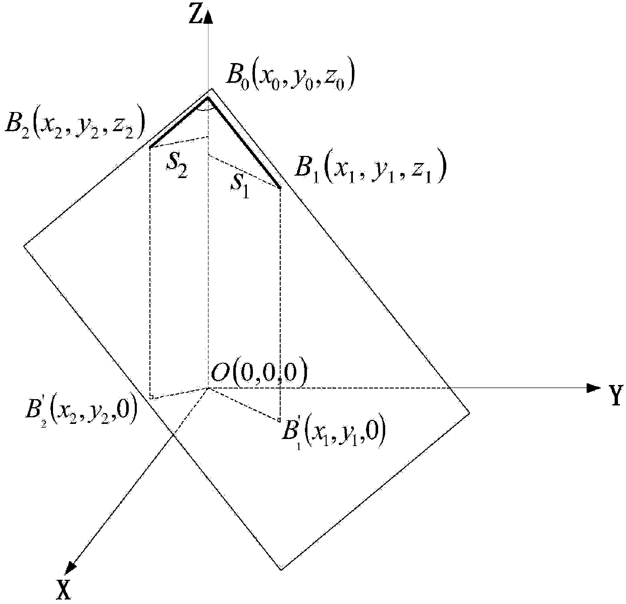
[0046] Such as figure 1 As shown, according to the farmland land leveling arbitrary gradient reference plane design method of the present invention comprises the following steps:

[0047] A. Select the reference point and design the initial reference slope;

[0048] B. Measure the topography of the farmland and obtain the actual topography data of the farmland;

[0049] C. Calculate the correction parameters to obtain the final reference slope design equation.

[0050] Wherein, step A further includes the following steps:

[0051] A1. Select the main reference point B 0 , usually choose the location of the water inlet or outlet of the farmland, so as to ensure that the position of the main reference point is as close as possible or at the desired reference surface; drive the forklift to this location ...


PUM


Abstract

The invention discloses a method for designing a farmland leveling arbitrary slope reference plane. The method mainly comprises the following steps: A, selecting a reference point, and designing an initial reference slope surface; B, measuring the farmland terrain to acquire practical farmland terrain data; C, calculating correction parameters to obtain a final reference slope plane design equation. According to the method, GNSS (Global Navigation Satellite System) differential positioning is utilized to acquire farmland terrain three-dimensional data, the reference plane with any three-dimensional slope direction and slope can be rapidly and conveniently designed according to three reference points, not only can a slopeless plane design can be achieved, but also a single longitudinal slope design can be achieved, and moreover any slope surface design in the two-dimensional direction can be achieved. The requirements on ground fine irrigation water flow direction can be flexibly met.

Description

technical field [0001] The invention relates to land leveling technology, in particular to a GNSS positioning-based design method for farmland land fine leveling with an arbitrary slope reference surface. Background technique [0002] With the development of my country's modern precision agriculture and the prominent contradiction between the supply and demand of agricultural water resources, improving surface irrigation technology has become an important part of modern agricultural water-saving technology. Improving the flatness of farmland can play a role in improving the efficiency and uniformity of field surface irrigation, and is one of the important technical elements for improving surface irrigation methods. At present, in terms of farmland leveling operations, there are mainly three methods of leveling, namely conventional leveling, laser control leveling and GNSS control leveling. [0003] The leveling equipment used in the conventional leveling method generally in...

Claims


Application Information

Patent Timeline
Patent Type & Authority Applications(China)
IPC IPC(8): G06F17/50G01S19/14
Inventor 刘刚李宏鹏牛东岭王岩李笑孟庆宽司永胜
Owner CHINA AGRI UNIV
Learn More