Automatic generating method for multi-lane vehicle track space-time diagram

An automatic generation, multi-lane technology, applied in the direction of image analysis, image data processing, instruments, etc., can solve the problems of reduced effect, reduced vehicle tracking accuracy, and influence on accurate judgment

Active Publication Date: 2014-07-02
JIANGSU ZHONGHAI HUA HE ENVIRONMENTAL PROTECTION CO LTD
View PDF4 Cites 63 Cited by
  • Summary
  • Abstract
  • Description
  • Claims
  • Application Information

AI Technical Summary

Problems solved by technology

The method based on motion foreground extraction and tracking can obtain the vehicle trajectory well when the traffic flow is smooth, but when there is traffic jam, slow traffic flow and mutual occlusion, the effect of this method will drop sharply or even fail
The method based on feature point extraction and tracking can better solve this problem, but it has a large amount of calculat

Method used


Image

  • Automatic generating method for multi-lane vehicle track space-time diagram
  • Automatic generating method for multi-lane vehicle track space-time diagram
  • Automatic generating method for multi-lane vehicle track space-time diagram

Examples


Embodiment Construction

[0126] The following describes the specific implementation of the present invention in conjunction with the accompanying drawings and examples.

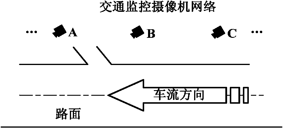
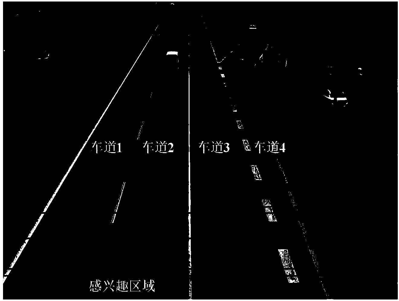
[0127] In the present invention, the acquisition of the traffic monitoring video is realized by using a fixed-installation traffic monitoring camera, and a certain angle θ is allowed between the horizontal orientation of the camera and the direction of road traffic flow, (0≤θfigure 1shown. Without loss of generality, the following will take the B camera as an example to illustrate. The camera is set up on the Houfeng Bridge with a height of 8 meters above the ground. In the scene, the number of lanes in the scene is 4, and the number of lanes (dividing) lines is 3. The shooting frame rate of the camera is 25 frames per second, and the image size of each frame is 640×480 pixels. The tracking method of the present invention adopts an execution method every other frame.

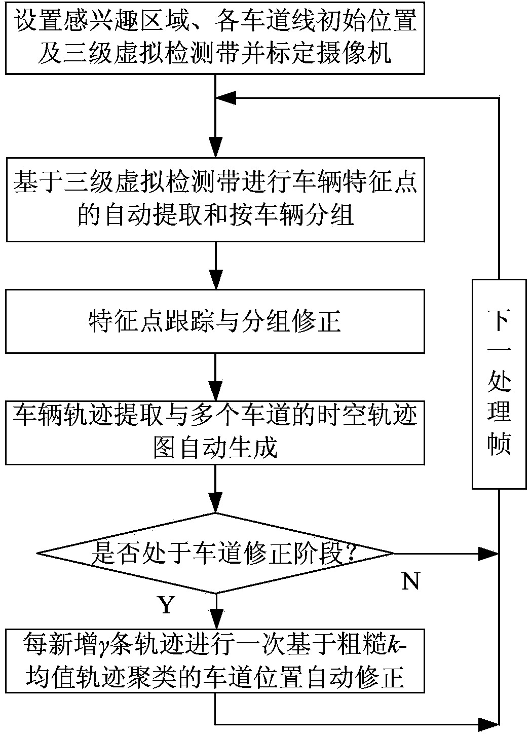
[0128] The overall flow chart of the method of the present inven...


PUM


Abstract

The invention relates to an automatic generating method for a multi-lane vehicle track space-time diagram. The method comprises the steps that firstly, a camera is utilized for obtaining internal parameters and external parameters of the camera through off-line calibration, an area of interest is set according to the actual monitoring requirement, and three virtual detecting belts are set at the upstream initial position of the traffic flow; secondly, the vehicle feature points are extracted based on the three virtual detecting belts, the feature point tracking and grouping correction are carried out according to vehicle grouping, the vehicle tracks are extracted in a high-precision mode, a longitudinal space-time track diagram of passing vehicles is automatically generated for each lane, and a transverse space-time track diagram comprising all lanes is generated; finally, whether it is in the lane line correction stage or not is automatically judged, wherein if yes, the lane line position is automatically corrected based on the track clustering method. Compared with the prior art, the method improves the robustness of the target luminance change, improves the precision of vehicle detecting and track tracing, is capable of well automatically correcting the lane line on line and avoids misjudgment on the lane number to which the vehicle track point belongs.

Description

technical field [0001] The invention belongs to the technical field of traffic and transportation monitoring, which uses computer video processing technology and pattern recognition technology to automatically extract road moving vehicle trajectories, and on this basis, automatically distinguishes the lane to which the vehicle belongs, and generates a longitudinal space-time map of vehicle trajectories in each lane and a horizontal space-time map of road sections. Background technique [0002] The space-time diagram of vehicle trajectory is the "time-position" coordinate representation during vehicle driving, in which time is usually taken as the abscissa axis, and the spatial position (longitudinal or horizontal) of the vehicle in the lane is the ordinate axis. The space-time map of vehicle trajectories has important application value in the field of transportation technology. It can not only provide a unified support platform for the acquisition of various traffic paramete...

Claims


Application Information

Patent Timeline
IPC IPC(8): G06K9/66G06T7/00
Inventor 陈阳舟任建强辛乐石建军李宝同刘逸男
Owner JIANGSU ZHONGHAI HUA HE ENVIRONMENTAL PROTECTION CO LTD
Why Eureka
Try Eureka