Navigation information generation method and system, mobile client and server

A mobile client, navigation information technology, applied in the information field, can solve problems such as user-provided errors, inconsistency in actual visual angles, affecting the accuracy of the navigation system, etc., to achieve the effect of improving accuracy, avoiding positioning errors and invalidation of navigation information

Active Publication Date: 2014-07-09
SHENZHEN INST OF ADVANCED TECH
View PDF7 Cites 34 Cited by
  • Summary
  • Abstract
  • Description
  • Claims
  • Application Information

AI Technical Summary

Problems solved by technology

[0007] The purpose of the present invention is to provide a method and system for generating navigation information, as well as a mobile client and a server, aiming at solving the problem that the navigation system existing in the prior art only relies on a single geographic positioning means to locate the user's location on a two-dimensional plane , it is very easy to provide users with wrong or vague positioning information and navigation services, which greatly affects the accuracy of the navigation system; in addition, most of the existing navi

Method used


Image

  • Navigation information generation method and system, mobile client and server
  • Navigation information generation method and system, mobile client and server
  • Navigation information generation method and system, mobile client and server

Examples


Embodiment Construction

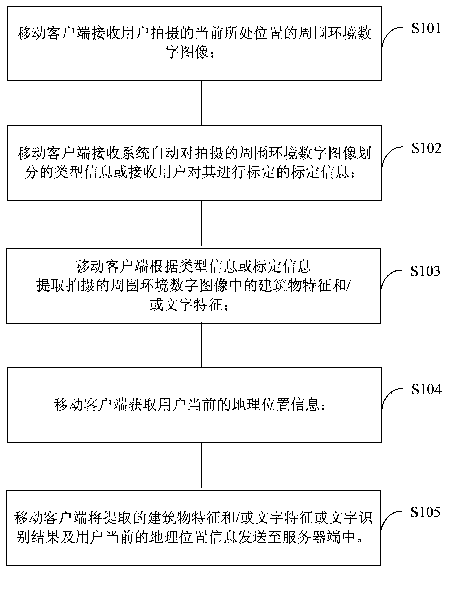
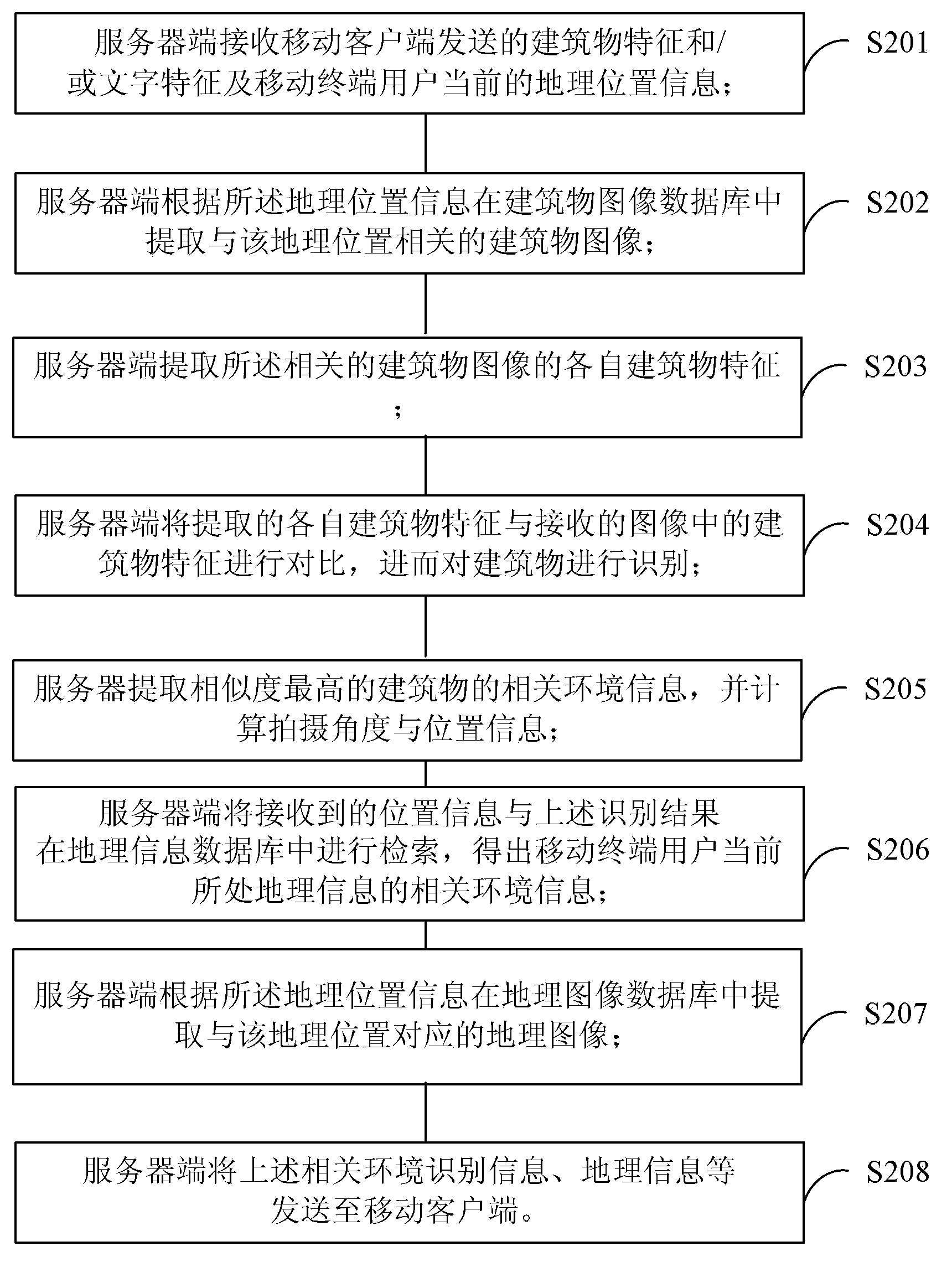
[0055] In order to make the object, technical solution and beneficial effects of the present invention more clear, the present invention will be further described in detail below in conjunction with the accompanying drawings and embodiments. It should be understood that the specific embodiments described here are only used to explain the present invention, not to limit the present invention.

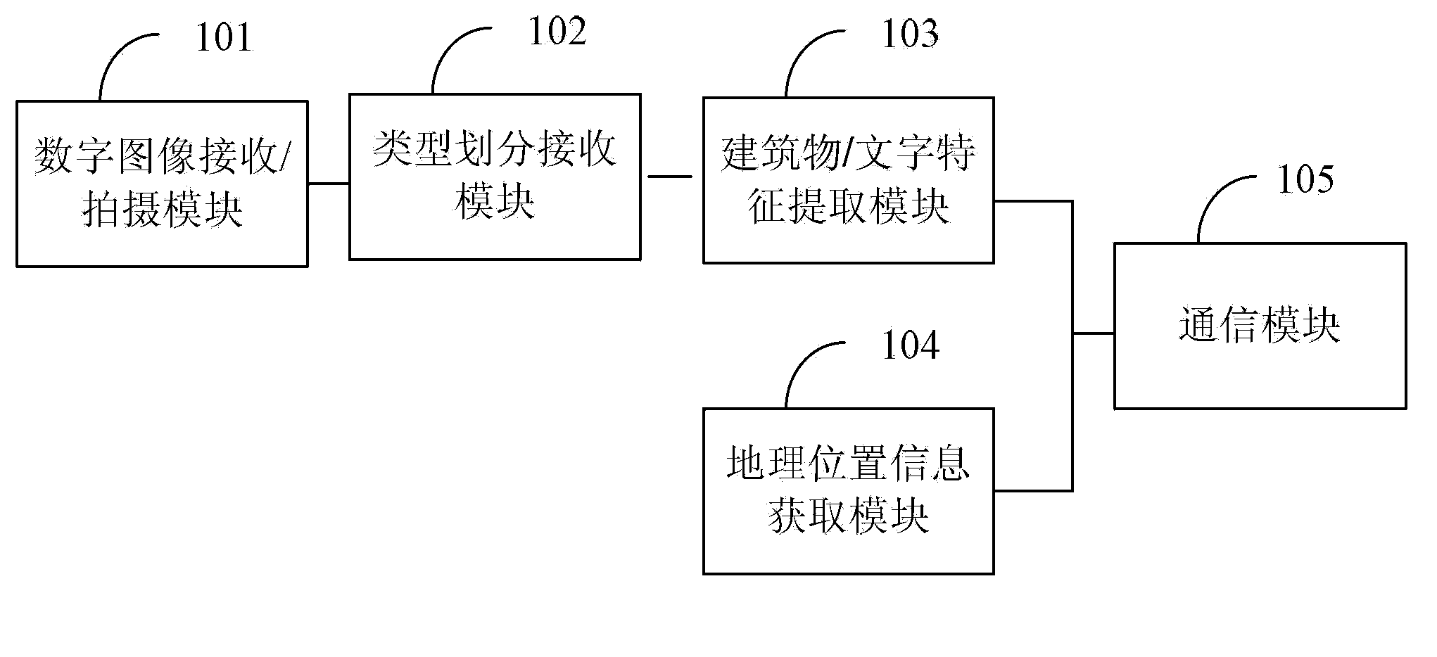
[0056] In the embodiment of the present invention, the embodiment of the present invention designs an environment recognition technical solution and a navigation technical solution based on user perspective and image content analysis. This technical solution can analyze and identify the text information of landmark buildings and road signs in the image on the server side according to the image taken by the user through the mobile terminal, and then calculate the geographical location and shooting orientation of the image, and determine the user's viewing angle direction. On the mobile cl...


PUM


Abstract

Being applicable to the field of information technologies, the invention provides a navigation information generation method and system. The method includes: letting a mobile client receive or shoot a surrounding environment digital image of a user's current location, after the image is detected qualified, extracting image features according to the image type and key area divided by the system automatically or calibrated by the user, sending the image features and geographical locating information to a server together so as to retrieve the environmental information of the image's key area part, at the same time, calculating the shooting position and the user's current visual angle by the server, then sending the environmental information and the visual angle information back to the mobile client, and fusing the information with the digital image on the mobile client by an augmented reality means to form a user's visual angle based environmental information fused and reality augmented navigation chart. The method provided by the invention can improve the accuracy of the navigation system, provide the user's visual angle based environmental information fused and reality augmented navigation chart, and strengthen the user experience.

Description

technical field [0001] The invention belongs to the field of information technology, and in particular relates to a method and system for generating navigation information, a mobile client and a server. Background technique [0002] The existing augmented reality car navigation system extracts various road condition features based on the images collected by the image acquisition device in real time, and judges the road conditions (including traffic signal features, lane features, pedestrian features, front motor vehicle features, non-motor vehicle features, etc.), Combined with the preset navigation route, generate navigation prompt information (including motor vehicle turning information, motor vehicle merging information, danger warning information, destination distance information, road name information, equipment status information), and superimpose the navigation prompt information on the on the current traffic image. It mainly provides road condition recognition and n...

Claims


Application Information

Patent Timeline
IPC IPC(8): G01C21/32
CPCG01C21/32
Inventor 乔宇邹静
Owner SHENZHEN INST OF ADVANCED TECH
Why Eureka
Try Eureka