Wireless sensor network covering method based on polar coordinates

A wireless sensor and network coverage technology, applied in the field of wireless sensor network coverage, can solve the problem of complex node location limitation and so on

Inactive Publication Date: 2014-07-09
HENAN UNIVERSITY
View PDF4 Cites 2 Cited by
  • Summary
  • Abstract
  • Description
  • Claims
  • Application Information

AI Technical Summary

Problems solved by technology

However, in the Cartesian coordinate system, it is more complicated to define the position of the node by the circular boundary, while in the polar coordinate system, the position of the node can be limited in the circular area by limiting the radius coordinates

Method used


Image

  • Wireless sensor network covering method based on polar coordinates
  • Wireless sensor network covering method based on polar coordinates
  • Wireless sensor network covering method based on polar coordinates

Examples


Embodiment Construction

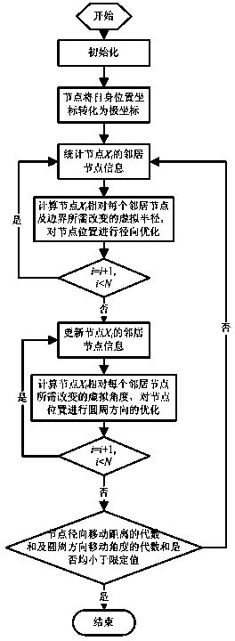
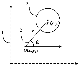
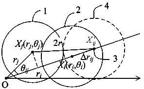
[0035] In the present invention, N wireless sensor nodes are randomly deployed in a circular area with a radius of R, through the conversion of polar coordinates, aiming at reducing the overlapping area of ​​sensing circles between nodes, adjusting the radius and angle of the nodes, and improving the network coverage. The sensing radius of the sensor node is r. When the sensing circles of two adjacent nodes in the area are tangent, there is no overlapping area between the sensing circles of the two nodes. At this time, the utilization rate of the sensing area of ​​the two nodes reaches the maximum. The position optimization of nodes is decomposed into radial optimization and circumferential optimization. During radial optimization, nodes can only move along the line from the origin to the node, and calculate the minimum distance that the node needs to move when it is tangent to the perceived circle of the neighbor node. , this distance is the virtual radius of the change of th...


PUM


Abstract

The invention discloses a wireless sensor network covering method based on polar coordinates. The method includes the following steps that first, the position of the origin of the polar coordinates is set by a server, and wireless sensor nodes are converted into polar coordinate position information according to the position relation between a rectangular coordinate system and a polar coordinate system; second, the polar coordinate position information of each wireless sensor node is sent to the neighbor nodes by the wireless sensor node; third, according to the position information of the neighbor nodes, the virtual radius of each node requiring to be changed when the node reaches the position tangent with the corresponding neighbor node in the radial direction relative to the neighbor node and the virtual radius of the node requiring to be changed when the node reaches the boundary expectation position are calculated; fourth, each node is moved to a new coordinate position; fifth, the virtual angle of each node requiring to be moved when the perception circle of the node reaches the position tangent with the perception of the corresponding neighbor node in the circumferential direction is calculated, and the position information of each new node is updated; sixth, the operation is ended or the second step is executed again. Through the method, the coverage of a wireless sensor network with the node deployment area being round can be improved.

Description

technical field [0001] The invention relates to a wireless sensor network covering method, in particular to a polar coordinate-based wireless sensor network covering method. Background technique [0002] At present, with the development of wireless sensor network technology and microelectronics manufacturing, wireless sensor networks composed of a large number of miniature sensor nodes with sensing capabilities, computing capabilities and communication capabilities are applied to military or civilian fields. Network coverage is one of the basic issues of wireless sensor networks, which reflects the monitoring degree of sensor network nodes to the designated monitoring area, and affects the cost of the network and the performance of the network in various specific applications to a large extent. [0003] According to different monitoring targets, wireless sensor network coverage algorithms can be divided into target coverage research and area coverage research. In the study ...

Claims


Application Information

Patent Timeline
IPC IPC(8): H04W16/18H04W24/02
Inventor 杜晓玉李辉周林贾笑明马晓燕
Owner HENAN UNIVERSITY
Why Eureka
Try Eureka