Route sign planning method of deep space detection autonomous navigation

A technology of autonomous navigation and deep space exploration, applied in the field of satellite navigation, can solve the problems of real-time, cost and resource constraints, and achieve the effect of simple implementation and small amount of calculation

Active Publication Date: 2014-07-30
BEIJING INST OF CONTROL ENG
View PDF4 Cites 4 Cited by
  • Summary
  • Abstract
  • Description
  • Claims
  • Application Information

AI Technical Summary

Problems solved by technology

But this requires a lot of ground operations and is limited in real-time, cost and resources

Method used


Image

  • Route sign planning method of deep space detection autonomous navigation
  • Route sign planning method of deep space detection autonomous navigation
  • Route sign planning method of deep space detection autonomous navigation

Examples


Embodiment

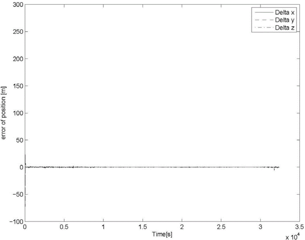
[0068] The target celestial body is asteroid 25413, and the six elements of the detector orbit are selected as a=0.75km, e=1 / 3, i=π / 2, ω=π, RAAN=0, f=π, and the detector distance is small at the beginning The distance from the center of the planet is 1km, and after flying half a circle, the distance is reduced to around 500m, and then active control is carried out there, so that it descends to the surface of the asteroid at a constant speed.

[0069] During navigation, landmark observation is performed every 30s. The position error 1σ of the landmark point is set to 15m, the Euler angle noise 1σ is 1e-5rad, the pixel noise 1σ is 8.801e-5, the initial position error of navigation is 300m in each direction, and the speed error is 0.02m / s.

[0070] Simulation results (such as figure 2 (shown) shows that when the filtering is converging, the navigation accuracy can reach the meter level.


PUM


Abstract

A route sign planning method of deep space detection autonomous navigation comprises the following steps: giving a navigation system information matrix expression based on visual line information according to the definition of a Fisher information matrix; establishing a relationship expression between an error variance matrix and the information matrix by utilizing a Cramer-Rao inequation, carrying out observability analysis based on the characteristic value information of the error variance matrix, and quantitatively assessing the influence of a route sign on the navigation system observability; and finally selecting an appropriate route sign to realize the largest autonomous navigation observability.

Description

technical field [0001] The invention belongs to the field of satellite navigation, and relates to a road sign planning method in a navigation method based on road sign sight information. Background technique [0002] The spacecraft navigation system is used to determine the position and attitude of the probe, which is the basic system to ensure that the probe can successfully carry out a series of scientific tasks. For deep space exploration missions, many current detectors rely on the Deep Space Network. But this requires a lot of ground operations, and is subject to various constraints in real-time, cost and resources. Therefore, whether it is from the perspective of reducing operating costs or improving performance, detectors are required to have a certain ability to operate autonomously. [0003] At present, the mainstream autonomous navigation method of deep space probes is the navigation method based on optical imaging measurement. For the target celestial body orbi...

Claims


Application Information

Patent Timeline
Patent Type & Authority Applications(China)
IPC IPC(8): G01C21/24
CPCG01C21/24
Inventor 王大轶李茂登黄翔宇李骥郭敏文
Owner BEIJING INST OF CONTROL ENG
Why Eureka
Try Eureka