Rice automatic mapping method based on ratio index of water body and vegetation index changes

A technology of vegetation index and ratio index, which is applied in electrical digital data processing, special data processing applications, instruments, etc., can solve the problems of low value of EVI time series data, rising water body index, lower than water body index, etc., to eliminate the water body index. Effects of changing interference, eliminating noise and precipitation, and improving classification accuracy

Active Publication Date: 2014-08-06
FUZHOU UNIV
View PDF2 Cites 17 Cited by
  • Summary
  • Abstract
  • Description
  • Claims
  • Application Information

AI Technical Summary

Problems solved by technology

However, the disadvantage of this method is that due to various factors such as noise interference, the influence of precipitation, and the range of remote sensing index values ​​in different regions may have certain differences, etc., it is directly based on the original signals of vegetation index and water index in a certain period. method has some limitations
For example: due to cloud factors, EVI time series data may appear abnormally low, even lower than the water index, resulting in misjudgment
Heavy precipitation may directly cause the water body index to rise and be higher than the vegetation index, which also causes misjudgment

Method used


Image

  • Rice automatic mapping method based on ratio index of water body and vegetation index changes
  • Rice automatic mapping method based on ratio index of water body and vegetation index changes
  • Rice automatic mapping method based on ratio index of water body and vegetation index changes

Examples


Embodiment Construction

[0027] The technical solution of the present invention will be specifically described below in conjunction with the accompanying drawings.

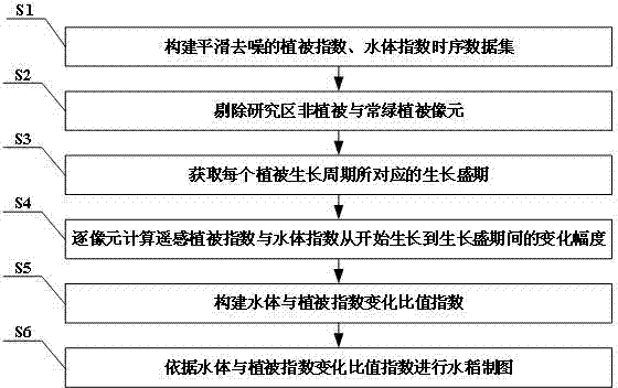
[0028] A kind of rice automatic mapping method based on the ratio index of water body and vegetation index change of the present invention comprises the following steps,

[0029] S01: Construct a smooth water body index and vegetation index time series data set;

[0030] S02: Eliminate non-vegetation and evergreen vegetation pixels in the study area;

[0031] S03: Obtain the peak growth period corresponding to each vegetation growth cycle pixel by pixel;

[0032] S04: Calculate the change range of water body index and vegetation index from the beginning of vegetation growth to the period of full growth;

[0033] S05: Construct the ratio index of water body and vegetation index change;

[0034] S06: Rice mapping based on the ratio index of water body and vegetation index change.

[0035] The method of the invention is applicable to the...


PUM


Abstract

The invention discloses a rice automatic mapping method based on a ratio index of water body and vegetation index changes. Based on time-series data sets within the year of a water body index and a vegetation index, the method detects a vegetation fast-growing stage corresponding to the vegetation index maximum in each growth cycle pixel by pixel, and establishes the ratio index of water body and vegetation index changes according to change amplitude of the remote sensing water body index and vegetation index from the beginning of growth to the fast-growing stage of vegetation, so as to carry out rice automatic mapping. The method makes full use of the characteristic that relative to other crops and natural vegetation, the change amplitude of the water body index is smaller, and the change amplitude of the vegetation index is larger during the period of time from transplanting to heading of a rice paddy field, and through the design of the ratio index of the water body and vegetation index changes based on the ratio of the two for rice mapping, the method has the characteristics of good robustness, high classification accuracy, high automation degree, strong anti-jamming capability and the like.

Description

technical field [0001] The invention relates to the technical field of remote sensing image information processing, in particular to an automatic rice mapping method based on the ratio index of water body and vegetation index change. Background technique [0002] Timely and accurate information on the spatial distribution of crops is crucial for formulating relevant policies and ensuring national food security. As one of the most important food crops in my country, rice plays an important role in food production. It is of great significance to quickly and automatically monitor the spatial distribution range of rice. The traditional manual survey method is not only time-consuming and laborious, but also difficult to achieve full coverage, and is easily interfered by subjective factors. Remote sensing images have the characteristics of strong timeliness and large coverage, and play an important role in crop area monitoring. However, due to the interference of spectral simil...

Claims


Application Information

Patent Timeline
Patent Type & Authority Applications(China)
IPC IPC(8): G06F19/00
Inventor 邱炳文齐文李维娇
Owner FUZHOU UNIV
Why Eureka
Try Eureka