Positioning and navigating method and system for indoor space
A technology of indoor space and navigation method, which is applied in the field of indoor space positioning and navigation and its system to achieve the effects of strong feasibility, convenient deployment and operation and maintenance, and low construction cost
- Summary
- Abstract
- Description
- Claims
- Application Information
AI Technical Summary
Problems solved by technology
Method used
Image
Examples
Embodiment 1
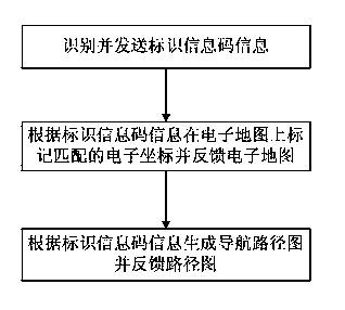
[0030] see figure 1 , figure 2 , as shown in the figure, a method for positioning and navigating an indoor space includes the following steps:
[0031] (1) The smart terminal identifies the identification information code arranged indoors, and sends the identification information code information to the server;
[0032] The user downloads and installs the client software with a smart terminal. When the user is located at a location point marked with an identification information code, the client can identify the identification information code, interpret the information of the identification information code, set the location point as the end point or starting point, and transfer the information sent to the server. For example, in an underground shopping mall, the identification information code laid out is a two-dimensional code, and the smart terminal scans the two-dimensional code at a certain location to interpret the two-dimensional code information. The intelligent t...
Embodiment 2
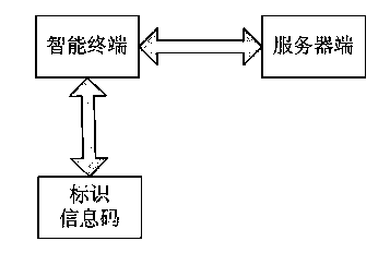
[0041] This embodiment provides a positioning and navigation system for indoor space, such as figure 2 As shown, it includes an intelligent terminal and a server, and a communication connection is provided between the intelligent terminal and the server.
[0042] The smart terminal includes an identification information code identification and analysis module and an electronic map identification module. Smart terminals are mainly used for identification, analysis and information transmission of identification information codes, transmission and identification of electronic maps.
[0043] The server end includes an identification information code identification and analysis module, an electronic map management module, and a route management module. The server side is mainly used for the production of identification information codes, the identification of identification information code information and its associated coordinates, the establishment, marking, storage and transm...
PUM
 Abstract
Description
Claims
Application Information
 - R&D
- Intellectual Property
- Life Sciences
- Materials
- Tech Scout
- Unparalleled Data Quality
- Higher Quality Content
- 60% Fewer Hallucinations
Browse by: Latest US Patents, China's latest patents, Technical Efficacy Thesaurus, Application Domain, Technology Topic, Popular Technical Reports.
© 2025 PatSnap. All rights reserved.Legal|Privacy policy|Modern Slavery Act Transparency Statement|Sitemap|About US| Contact US: help@patsnap.com


