Method for optimizing land subsidence monitoring net

A land subsidence and monitoring network technology, applied in special data processing applications, instruments, electrical digital data processing, etc., can solve the problems of reduced monitoring point accuracy, inaccurate atmospheric estimation, data collection and processing errors, etc., to optimize PSInSAR monitoring point effect

Inactive Publication Date: 2014-10-29
CAPITAL NORMAL UNIVERSITY
View PDF2 Cites 21 Cited by
  • Summary
  • Abstract
  • Description
  • Claims
  • Application Information

AI Technical Summary

Problems solved by technology

[0003] Conventional land subsidence monitoring methods mainly include leveling, stratification and GPS measurement. With the development of earth observation technology, Synthetic Aperture Radar Interferometry (InSAR, Interferometric Synthetic Aperture Radar) technology is applied to land subsidence monitoring. In the interferogram formed by two SAR images, the image phase includes the terrain phase of the region and the deformation of the ground during the observation period, and what we want is only the deformation information of the surface, so the terrain information of the region must be removed, so further Extended the synthetic aperture radar differential interferometry (DInSAR, Differential Interferometry Synthetic Aperture Radar) technology, DInSAR technology has the advantages of wide coverage, high resolution, all-weather, etc., but the accuracy of monitoring points is reduced due to the influence of phase loss correlation and atmospheric delay
Permanent Scatterer Interferometry (PSInSAR, Permanent Scatterer Interferometry Synthetic Aperture Radar) technology extracts surface deformation information by analyzing permanent scattering points with stable scattering characteristics, which solves the shortage of DInSAR to a certain extent, but conventional PSInSAR technology has too many parameters to deal with. In the case of a large area, the estimation of the atmosphere will not be accurate enough, and there are certain errors in data collection and processing that lead to unreliable monitoring points, which has certain limitations on the unevenness of subsequent land subsidence

Method used


Image

  • Method for optimizing land subsidence monitoring net
  • Method for optimizing land subsidence monitoring net
  • Method for optimizing land subsidence monitoring net

Examples


Embodiment 1

[0054] A method for optimizing a land subsidence monitoring network, the method comprising the steps of:

[0055] 1) Establish a ground monitoring network;

[0056] Said establishment of a ground monitoring network includes laying out GPS points and benchmarking points in the land subsidence area, and setting up a GPS and leveling monitoring network to obtain ground subsidence monitoring points;

[0057] Among them, the establishment of GPS and leveling monitoring network includes the following steps:

[0058] 1.1 GPS points and leveling points are laid out in the land subsidence area. Each buried GPS monitoring station adopts forced centering and has a leveling measurement mark, which can be directly guided to the GPS point by leveling measurement. High density, GPS ground subsidence monitoring and leveling measurement are carried out at the same time to ensure that the monitoring results of the two are synchronized;

[0059] 1.2 During the measurement, the adjacent GPS poi...

Embodiment 2

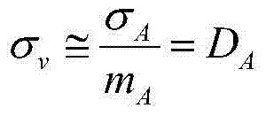
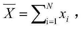
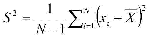
[0080] A method for optimizing the land subsidence monitoring network, the method is different from embodiment 1, utilizes the cloud model algorithm to utilize the reverse cloud generator to calculate, and the algorithm is as follows:

[0081] Compute the sample mean: X ‾ = Σ i = 1 N x i , Compute the sample variance: S 2 = 1 N - 1 Σ i = 1 N ( x i - X ‾ ) 2

[0082] E ...

Embodiment 3

[0089] A method for optimizing the land subsidence monitoring network, the method is different from embodiment 2, the method also includes the following steps:

[0090] 3) Establish an air-ground-underground three-dimensional monitoring network;

[0091] The air-ground-underground three-dimensional monitoring network is formed by integrating the optimized groundwater monitoring network with the optimized PSInSAR monitoring points, benchmarking points and GPS points;

[0092] The establishment of the optimized groundwater monitoring network includes the following steps:

[0093] c. Optimize the selection of regional groundwater monitoring network by using the groundwater dynamic type mapping method;

[0094] Among them, using the groundwater dynamic type mapping method to optimize the selection of regional groundwater monitoring network includes the following steps: according to different groundwater dynamic types, classify and partition the groundwater dynamics in the land su...


PUM


Abstract

The invention relates to a method for optimizing a land subsidence monitoring net. The method includes the following steps that firstly, a ground monitoring net is built, wherein a GPS point and a benchmark are arranged in a land subsidence area, a GPS and a leveling monitoring net are built, and therefore a land subsidence monitoring point is obtained; secondly, an air-land monitoring net is built, and the air-land monitoring net is formed by merging an optimized PSInSAR monitoring point, the benchmark and the GPS point, wherein obtaining of the optimized PSInSAR monitoring point includes the step of obtaining the PSInSAR monitoring point through the PSInSAR technology and obtaining three cloud numerical characteristics of the PSInSAR monitoring point through the cloud model algorithm. According to the method for optimizing the land subsidence monitoring net, the land subsidence monitoring capability can be improved, high-precision land subsidence monitoring information can be obtained, and the property safety and the life safety of the masses are protected.

Description

technical field [0001] The invention belongs to the field of geological disaster monitoring, in particular to a method for optimizing a land subsidence monitoring network. Background technique [0002] Land subsidence is an environmental geological phenomenon caused by the lowering of ground elevation, which will cause permanent loss of environmental resources. According to statistics, 95 cities in my country have experienced land subsidence, with a total area of ​​48,655 square kilometers. With the continuous development of the city, the hazards of land subsidence, especially uneven ground subsidence, have gradually become prominent. The subsidence causes the building base to be out of balance, and even induces the collapse of the entire building. At the same time, it will also have a great impact on underground facilities. [0003] Conventional land subsidence monitoring methods mainly include leveling, stratification and GPS measurement. With the development of earth obse...

Claims


Application Information

Patent Timeline
Patent Type & Authority Applications(China)
IPC IPC(8): G06F19/00
Inventor 宫辉力陈蓓蓓李小娟赵文吉周超凡郭琳段光耀颉晋荣贾煦史珉
Owner CAPITAL NORMAL UNIVERSITY
Why Eureka
Try Eureka