Beidou inertial navigation deep integration navigation microsystem

A deep integrated navigation and micro-system technology, applied in the field of navigation systems, can solve the problems of satellite navigation being susceptible to interference, navigation accuracy decline, and inability to navigate, so as to improve anti-interference and application reliability, improve anti-interference ability, The effect of improving accuracy

Active Publication Date: 2014-12-03
CHINA ELECTRONICS TECH GRP NO 26 RES INST
View PDF4 Cites 12 Cited by
  • Summary
  • Abstract
  • Description
  • Claims
  • Application Information

AI Technical Summary

Problems solved by technology

At the same time, both have their own limitations: satellite navigation is susceptible to interference, and cannot provide accurate navigation parameters in complex terrain conditions such as cities,

Method used


Image

  • Beidou inertial navigation deep integration navigation microsystem
  • Beidou inertial navigation deep integration navigation microsystem
  • Beidou inertial navigation deep integration navigation microsystem

Examples


Embodiment Construction

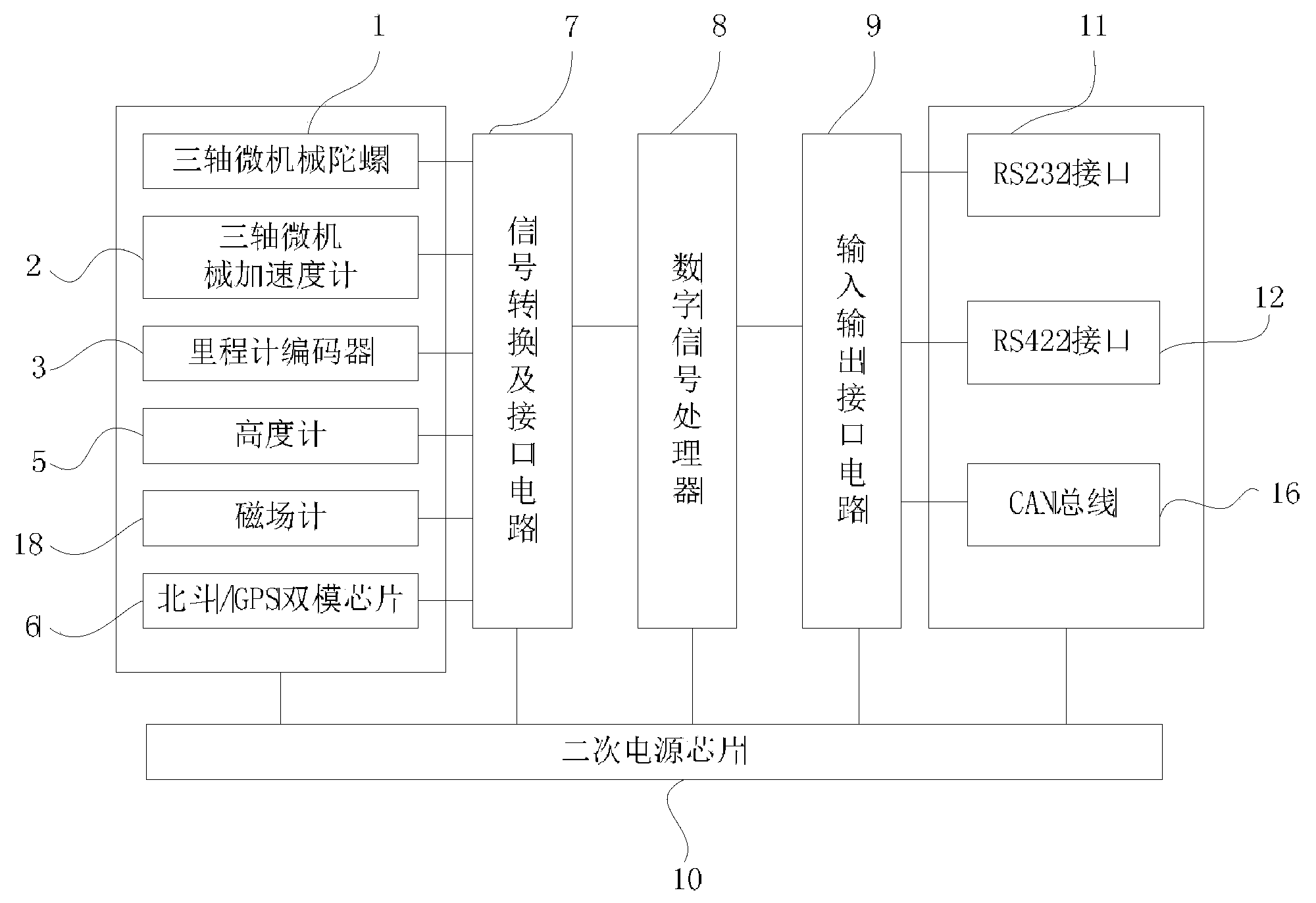
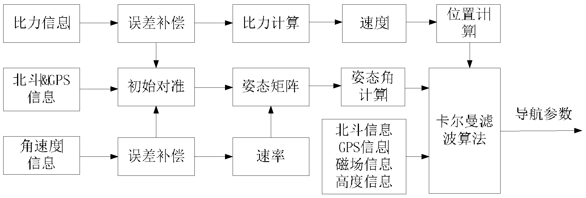
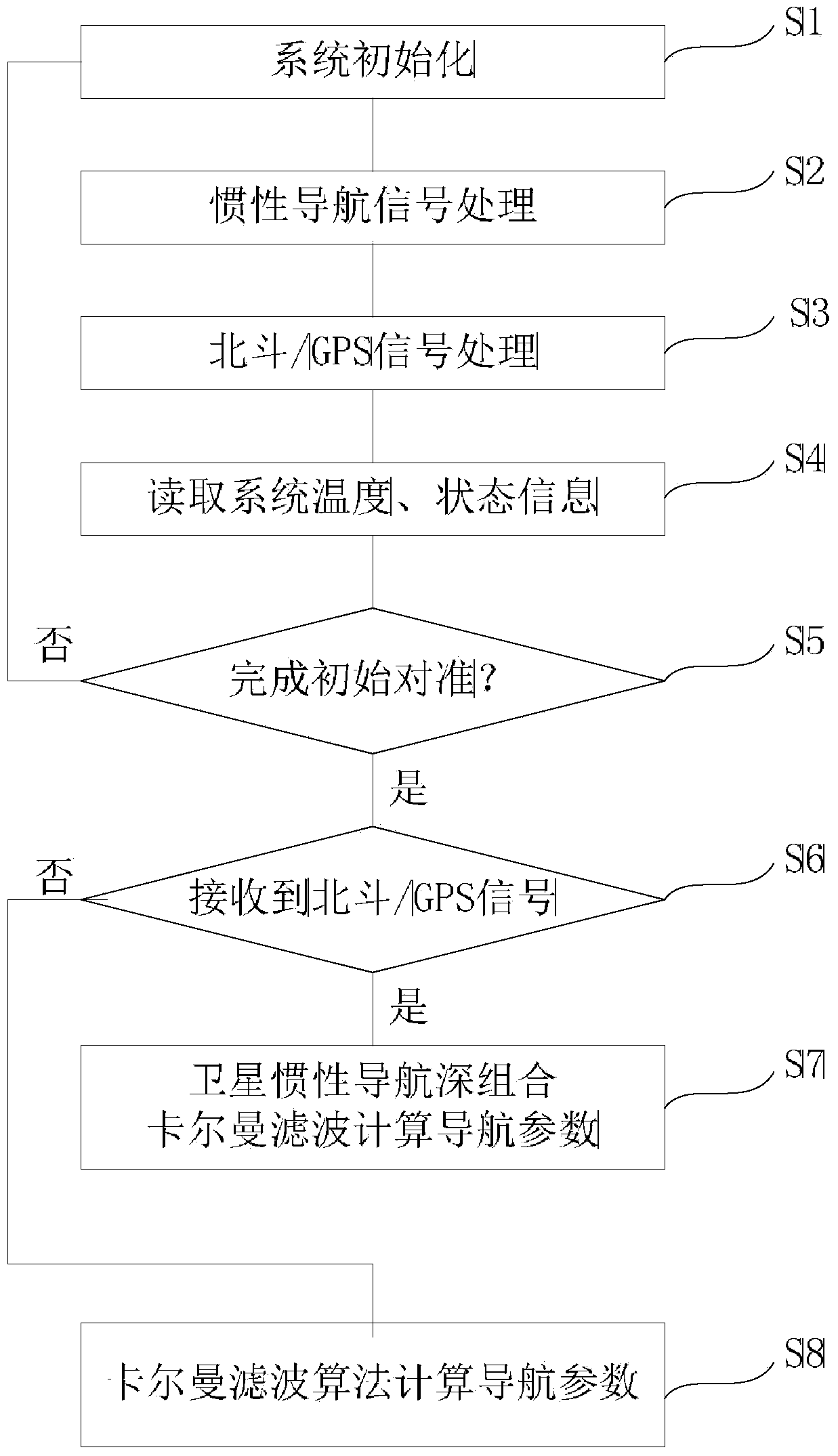
[0023] The following will clearly and completely describe the technical solutions in the embodiments of the present invention with reference to the accompanying drawings in the embodiments of the present invention. Obviously, the described embodiments are only some, not all, embodiments of the present invention. Based on the embodiments of the present invention, all other embodiments obtained by persons of ordinary skill in the art without making creative efforts belong to the protection scope of the present invention.

[0024] It should be understood that although terms such as "first" and "second" may be used herein to describe various elements, these elements should not be limited by these terms. These terms are only used to distinguish one element from another. Thus, a "first" element discussed below could also be termed a "second" element without departing from the teachings of the present invention. It will be understood that when an element is referred to as being "con...


PUM


Abstract

The invention discloses a Beidou inertial navigation deep integration navigation microsystem. The Beidou inertial navigation deep integration navigation microsystem comprises a three-axis micromechanical gyroscope, a three-axis micromechanical accelerometer, an odometer encoder, an altimeter, a magnetic field meter, a Beidou/GPS dual-mode chip, a signal conversion and interface circuit, a digital signal processor and a secondary power chip, wherein the digital signal processor is used for receiving digital signals converted by the signal conversion and interface circuit and calculating digital signals corresponding to the angular speed and the accelerated speed so as to obtain the speed and the displacement of a carrier, and the digital signal processor is further used for carrying out the Kalman filtering algorithm on digital signals corresponding to the speed and the displacement of the carrier, travel information, height information, magnetic field information, Beidou signals and GPS signals so as to obtain navigation parameters. According to the Beidou inertial navigation deep integration navigation microsystem, a Beidou, the gyroscope, the accelerometer, the magnetic field meter, the altimeter and functional chips of signal conversion, digital signal processing and the like are organically integrated, full-parameter navigation and seamless navigation can be achieved, and interference resistance and application reliability of the whole navigation system are improved.

Description

technical field [0001] The invention relates to a navigation system, in particular to a Beidou inertial navigation deep integrated navigation microsystem. Background technique [0002] In the field of navigation, satellite navigation and inertial navigation have their own advantages: satellite navigation can provide absolute position, speed, and time without time drift, and can maintain high precision for a long time; inertial navigation has continuity, concealment, and can measure all movements Parameters, high short-term precision. At the same time, both have their own limitations: satellite navigation is susceptible to interference, and cannot provide accurate navigation parameters in complex terrain conditions such as cities, mountains, tunnels, forests, or even navigation; and inertial navigation is limited by sensors. Navigation accuracy decreases rapidly over time, and it is impossible to maintain accurate navigation for a long time. Contents of the invention [0...

Claims


Application Information

Patent Timeline
IPC IPC(8): G01S19/47G01S19/33
CPCG01C21/165G01S19/33G01S19/49
Inventor 李星海胡旭伯
Owner CHINA ELECTRONICS TECH GRP NO 26 RES INST
Why Eureka
Try Eureka