Rural resident point information extraction method based on high-resolution remote-sensing image

A high-resolution, remote sensing image technology, used in instruments, character and pattern recognition, computer parts, etc., can solve problems such as very sensitive texture areas, achieve improved accuracy and effect, good robustness and universality, Overcome the effect of image quality

Inactive Publication Date: 2014-12-03
SHANDONG LINYI TOBACCO
View PDF2 Cites 24 Cited by
  • Summary
  • Abstract
  • Description
  • Claims
  • Application Information

AI Technical Summary

Problems solved by technology

Although the Harris corner detection algorithm is very accurate in locating corners and can detect a large number of corners inside residential areas, the disadvantage is that this method is very sensitive to textured areas, and it is easy to detect in some no...

Method used


Image

  • Rural resident point information extraction method based on high-resolution remote-sensing image
  • Rural resident point information extraction method based on high-resolution remote-sensing image
  • Rural resident point information extraction method based on high-resolution remote-sensing image

Examples


Embodiment Construction

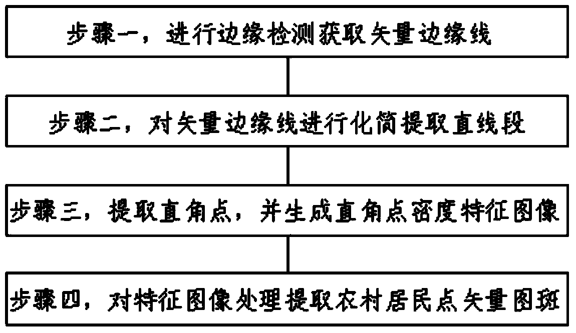
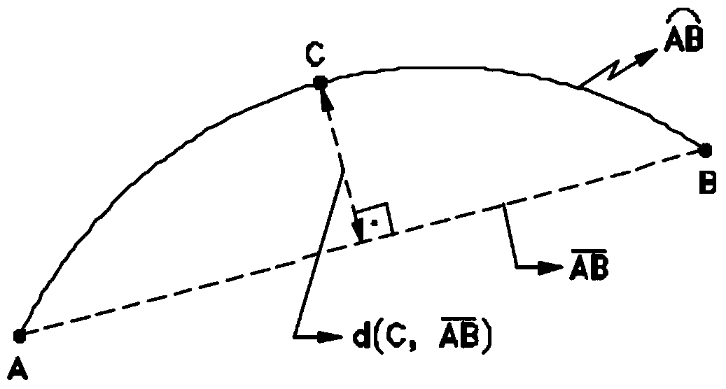
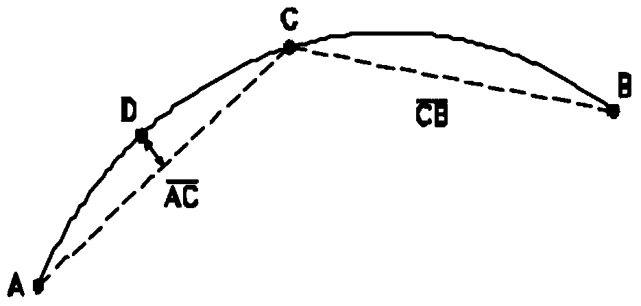
[0034] In order to clearly illustrate the technical features of this solution, the present invention will be described in detail below through specific implementation modes and in conjunction with the accompanying drawings. The following disclosure provides many different embodiments or examples for implementing different structures of the present invention. To simplify the disclosure of the present invention, components and arrangements of specific examples are described below. Furthermore, the present invention may repeat reference numerals and / or letters in different instances. This repetition is for the purpose of simplicity and clarity and does not in itself indicate a relationship between the various embodiments and / or arrangements discussed. It should be noted that components illustrated in the figures are not necessarily drawn to scale. Descriptions of well-known components and processing techniques and processes are omitted herein to avoid unnecessarily limiting the...


PUM


Abstract

The invention discloses a rural resident point information extraction method based on a high-resolution remote-sensing image. The rural resident point information extraction method comprises the following steps: firstly, carrying out Canny edge detection on the high-resolution remote-sensing image, and obtaining a vector edge line through chain code tracking; then, carrying out Douglas-Peucker abbreviation on a vector edge to extract straight-line segments, and rejecting shorter straight-line segments and keeping longer straight-line segments according to length constraints; secondly, according to adjacency relation between the straight-line segments and included angle constraints, extracting straight angle points, calculating the density characteristics of the straight angle points within a certain space region range, and generating a straight angle point density characteristic image, wherein the characteristic image and the input high-resolution remote-sensing image have same spatial range and spatial resolution; and finally, carrying out binarization processing on the density characteristic image by utilizing Otsu, extracting rural resident point vector pattern spots through connected component analysis so as to extract rural resident point information. Precision and effects are improved, and robustness and universality are better.

Description

technical field [0001] The invention relates to a method for extracting remote sensing image information, in particular to a method for extracting rural settlement information based on high-resolution remote sensing images, and belongs to the technical field of image intelligent processing. Background technique [0002] Urbanization is a process in which population continues to gather in cities and towns. It is an inevitable historical stage in the process of industrialization in all countries in the world. It is an important symbol in the process of industrialization and modernization, and it reflects the qualitative change and optimization of social production and lifestyle. my country did not usher in the wave of urbanization until after the reform and opening up. According to the National Bureau of Statistics, China's urbanization level rose from 17.9% in 1978 to 52.6% in 2012, an increase of 34.7 percentage points, with an average annual increase of 1.0 percentage point...

Claims


Application Information

Patent Timeline
IPC IPC(8): G06K9/46
Inventor 董梅苏建东刘广玉杨举田林祥国倪欢郑成鹏田雷张彦东王梅勋王家民李联玉梅兴霞宗浩徐硕武博谭效磊王丽丽王苜华
Owner SHANDONG LINYI TOBACCO
Why Eureka
Try Eureka