Method for rapidly constructing 2.5-dimensional building model

A construction method and building technology, applied in the field of geographic information, can solve the problems of large amount of data, insufficient intuitive experience of map product scenes, and large resources occupied, so as to achieve the effect of reducing the amount of data

Inactive Publication Date: 2014-12-03
山东省国土测绘院
View PDF2 Cites 19 Cited by
  • Summary
  • Abstract
  • Description
  • Claims
  • Application Information

AI Technical Summary

Problems solved by technology

The two-dimensional electronic map has fast mapping and drawing speed, can provide and meet the query, analysis and management needs of most geographic information products for spatial location, but because of the lack of real world sense of space (no three-dimensional sense), the map The intuitive experience of the product scene is insufficient, and the expression of geographical objects through two-dimensional symbols cannot satisfy people's sense of three-dimensional space cognition, and it is impossible to complete data measurement in three-dimensional space based on two-dimensional maps

Method used


Image

  • Method for rapidly constructing 2.5-dimensional building model
  • Method for rapidly constructing 2.5-dimensional building model
  • Method for rapidly constructing 2.5-dimensional building model

Examples


Embodiment Construction

[0062] The present invention will be described in further detail below through specific implementation examples and in conjunction with the accompanying drawings.

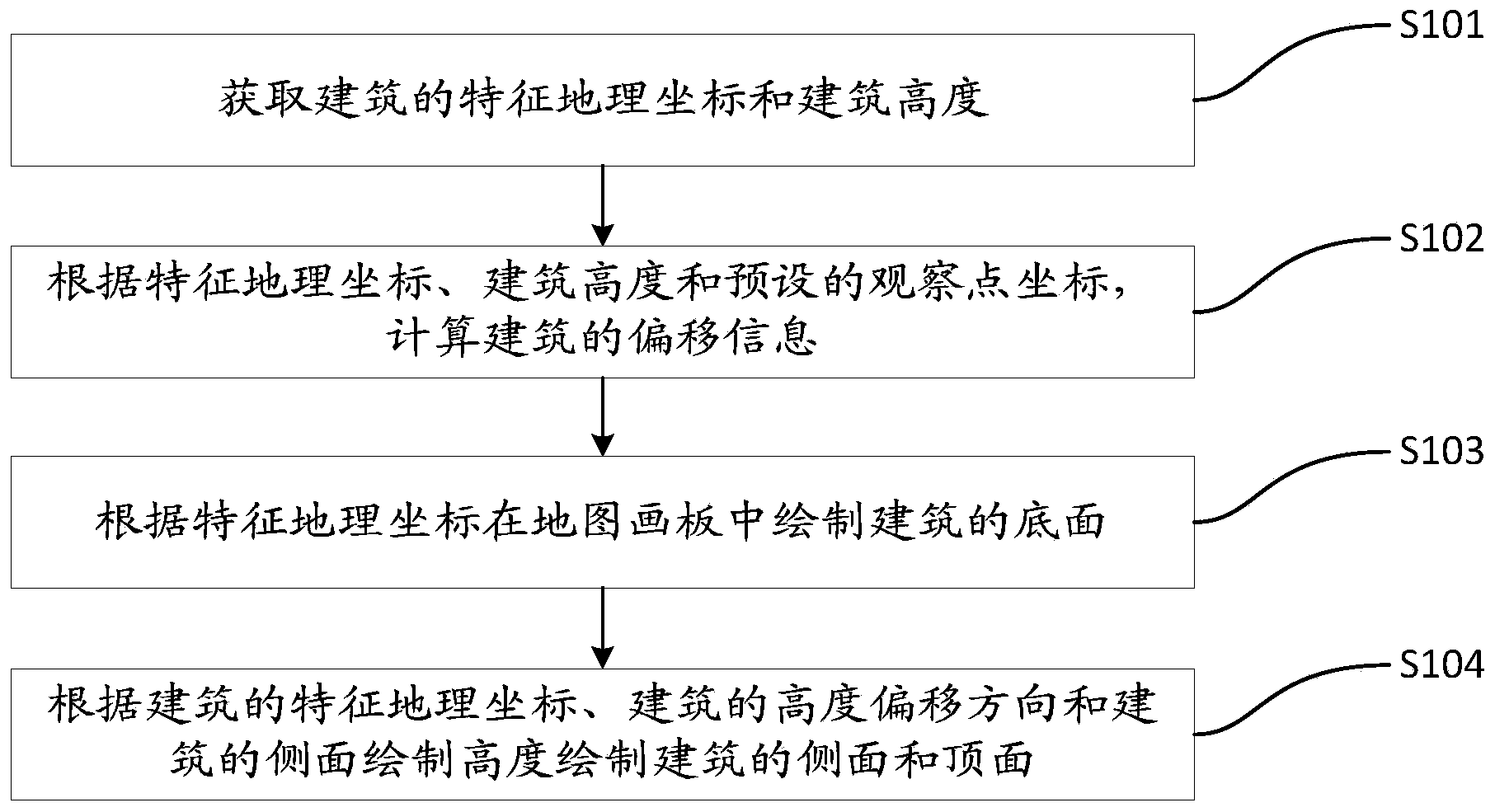
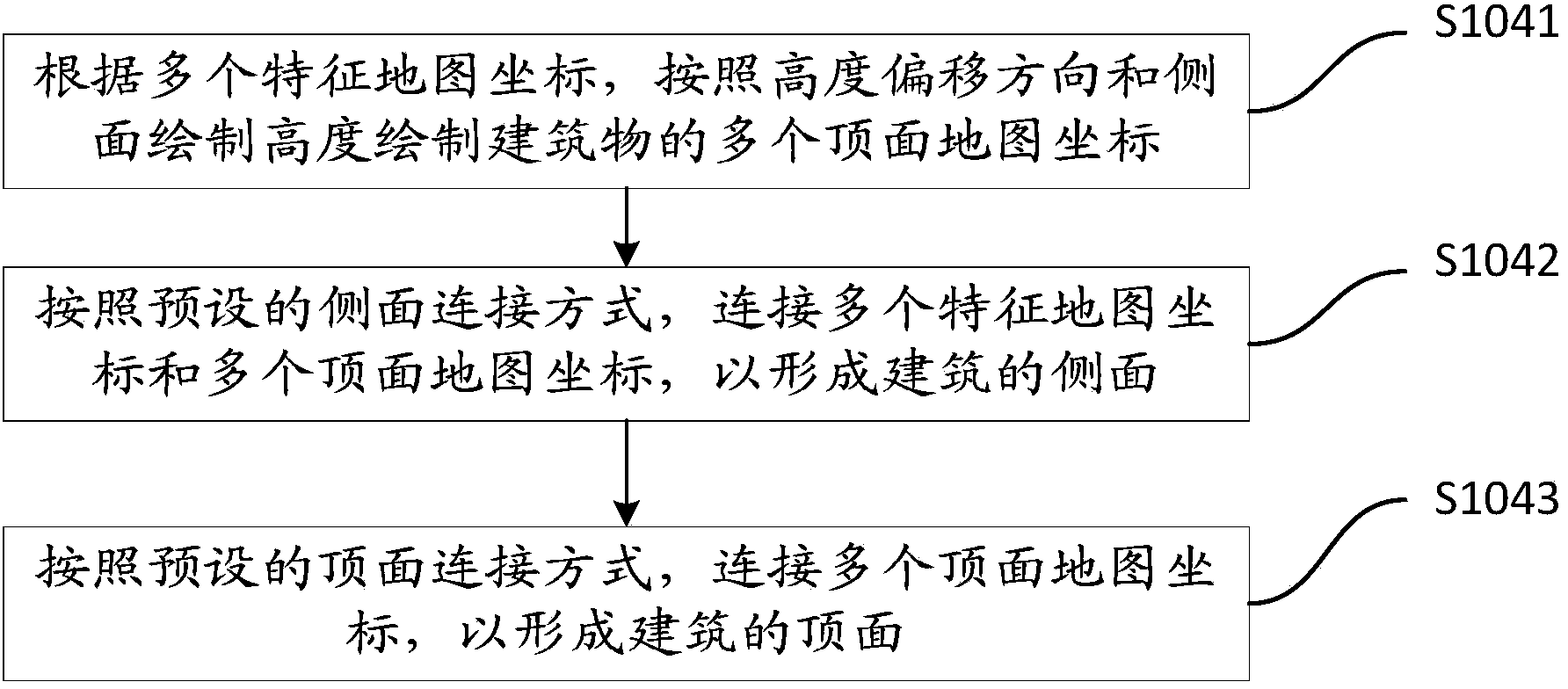
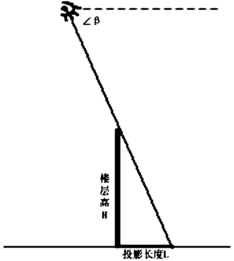
[0063] In related technologies, the 2.5-dimensional building model is a two-dimensional figure that maps the building onto a certain plane according to certain projection rules according to the storey height to display a three-dimensional effect. There are two main types of 2.5D map generation algorithms.

[0064] The first type of real-time rendering generation algorithm is generally limited to the mobile device side. According to the user's viewing angle and screen rectangle range generated by the user's operation screen, the local real-time calculation and rendering generate a 2.5-dimensional electronic map. The advantage of this type of algorithm is that its 2.5-dimensional electronic map is associated with the user's perspective and has a better user experience, but its disadvantage is that real-time calculati...


PUM


Abstract

The invention relates to the technical field of geographic information, in particular to a method for rapidly constructing a 2.5-dimensional building model. The method for rapidly constructing the 2.5-dimensional building model includes the steps that corresponding coordinates of geographical coordinates on a map are calculated by obtaining the feature geographical coordinates and the building height of a building, the height offset direction and the offset distance are determined according to the feature geographical coordinates, the building height and coordinates of an observation point, then the lateral sides and the top side of the building are drawn, and drawing of the map is accordingly completed. Compared with the prior art that a two-dimensional map can not show the sufficient space sense, and although a three-dimensional map can show the sufficient space sense, the size of data needing to be processed is greatly increased, the method for rapidly constructing the 2.5-dimensional building model has the advantages that a three-dimensional image can be displayed on a planar map drawing board, and the data number of image drawing is also decreased.

Description

technical field [0001] The invention relates to the technical field of geographic information, in particular to a fast method for constructing a 2.5-dimensional building model. Background technique [0002] With the rapid development and integration of modern surveying and mapping technology, computer technology, network communication technology and the Internet, applications related to geospatial space are growing rapidly. Indispensable basic information resources. [0003] In related technologies, electronic maps can be divided into two types in terms of their display methods. The first type is a two-dimensional map, and the second type is a three-dimensional map. Electronic map services are mainly two-dimensional maps, which provide spatial positioning and basic query and search functions for building information, and meet people's needs for using geospatial information to a certain extent. The two-dimensional electronic map uses the superimposition of three graphical s...

Claims


Application Information

Patent Timeline
IPC IPC(8): G06T17/00G06T15/00
Inventor 孔兆慧相恒茂张伟焦英华杨浚叶梓
Owner 山东省国土测绘院
Why Eureka
Try Eureka