Inertial navigation error correction method based on geomagnetism modulus gradient and particle filter

A modulus gradient and error correction technology, which is applied in the field of underwater geomagnetic-assisted navigation and positioning, can solve problems such as inability to adapt to large initial errors, and achieve the effect of reducing boundary effects

Active Publication Date: 2014-12-17
HARBIN ENG UNIV
View PDF2 Cites 32 Cited by
  • Summary
  • Abstract
  • Description
  • Claims
  • Application Information

AI Technical Summary

Problems solved by technology

Track geometry matching algorithms such as correlation matching, ICCP, etc. require a small initial position error and cannot meet the requirements of a large initial error
The method of estimating

Method used


Image

  • Inertial navigation error correction method based on geomagnetism modulus gradient and particle filter
  • Inertial navigation error correction method based on geomagnetism modulus gradient and particle filter
  • Inertial navigation error correction method based on geomagnetism modulus gradient and particle filter

Examples


Embodiment Construction

[0031] Embodiments of the present invention are described in detail below in conjunction with accompanying drawings:

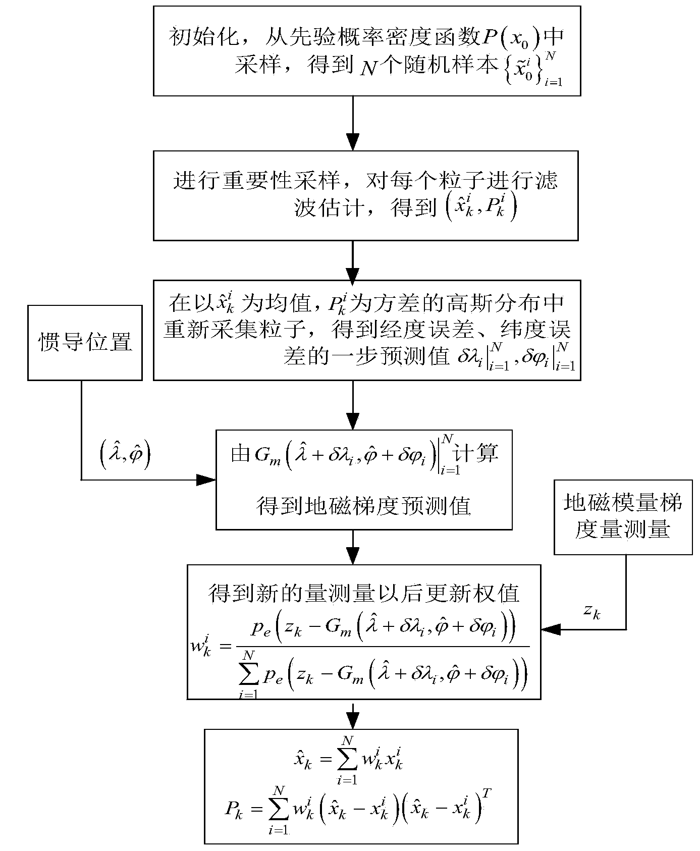
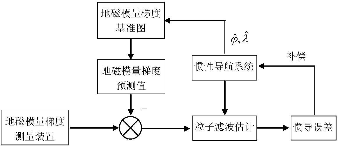
[0032] An inertial navigation error correction method based on geomagnetic modulus gradient and particle filter of the present invention uses geomagnetic anomaly data to construct an underwater geomagnetic modulus gradient reference map in advance and stores it in an integrated navigation computer. The geomagnetic modulus gradient measurement device obtains the measured value of the geomagnetic modulus gradient at the location of the carrier in real time, and the inertial navigation system calculates the location of the carrier, and finds the predicted value of the geomagnetic modulus gradient on the geomagnetic modulus gradient reference map according to the calculated position. The difference between the measured value and the predicted value of the geomagnetic modulus gradient is used as the observation information. The particle filter technology is used to ...


PUM


Abstract

The invention belongs to the field of geomagnetism auxiliary navigation location, and in particular relates to an inertial navigation error correction method based on geomagnetism modulus gradient and particle filter. The method comprises the following steps: solving the position on which a carrier is arranged by adopting an inertial navigation system according to the information of an accelerometer on a submarine; predicting the position error of the carrier according to a state equation of a geomagnetism modulus gradient/inertial combination navigation system; acquiring the geomagnetism modulus gradient measurement value of the submarine on a real position in real time by utilizing a geomagnetism modulus gradient measuring device when the submarine sails underwater; obtaining a difference value between the predicted modulus gradient value and the observed modulus gradient value; estimating the system state by utilizing a particle filter estimation algorithm based on the mass point dynamics physicomimetics optimization, and carrying out the error compensation on the inertial navigation system. According to the method, the sailing track of the carrier is corrected according to an estimation result, and the drifting of the inertial navigation gyroscope is estimated and compensated. An ideal way is provided for the underwater carrier to realize the precise autonomous navigation.

Description

technical field [0001] The invention belongs to the field of underwater geomagnetic aided navigation and positioning, and in particular relates to an inertial navigation error correction method based on geomagnetic modulus gradient and particle filter. Background technique [0002] In order to ensure the normal operation of the underwater carrier, the carrier must have long-term underwater high-precision navigation and positioning capabilities, which puts forward high requirements for underwater navigation technology. As the core equipment of the underwater navigation system, the positioning error of the inertial navigation system accumulates over time and must be readjusted and corrected. The geomagnetic field is the inherent physical field of the earth. Underwater geomagnetic navigation and positioning has the characteristics of passive, non-radiation, all-time, and all-regional. It is one of the ideal ways to realize real-time, continuous and accurate underwater autonomou...

Claims


Application Information

Patent Timeline
IPC IPC(8): G01C25/00
CPCG01C25/005
Inventor 黄玉武立华
Owner HARBIN ENG UNIV
Why Eureka
Try Eureka