
Object-oriented water-body extracting method based on ENVISAT ASAR and Landsat TM remote sensing data

An object-oriented, remote sensing data technology, used in image data processing, electrical digital data processing, special data processing applications, etc., can solve the problems of low extraction accuracy, complex and difficult to operate water extraction methods, and achieve the effect of simple and easy operation.

Inactive Publication Date: 2014-12-17
NORTHEAST INST OF GEOGRAPHY & AGRIECOLOGY C A S
View PDF3 Cites 19 Cited by
  • Summary
  • Abstract
  • Description
  • Claims
  • Application Information

AI Technical Summary

Problems solved by technology

[0005] The present invention aims to solve the problems of low extraction accuracy, complex and difficult-to-operate water body extraction methods in the existing methods for extracting water body information using remote sensing images, and provides an object-oriented water body extraction method based on ENVISAT ASAR and Landsat TM remote sensing data

Method used


Image

  • Object-oriented water-body extracting method based on ENVISAT ASAR and Landsat TM remote sensing data
  • Object-oriented water-body extracting method based on ENVISAT ASAR and Landsat TM remote sensing data
  • Object-oriented water-body extracting method based on ENVISAT ASAR and Landsat TM remote sensing data

Examples


specific Embodiment approach 1

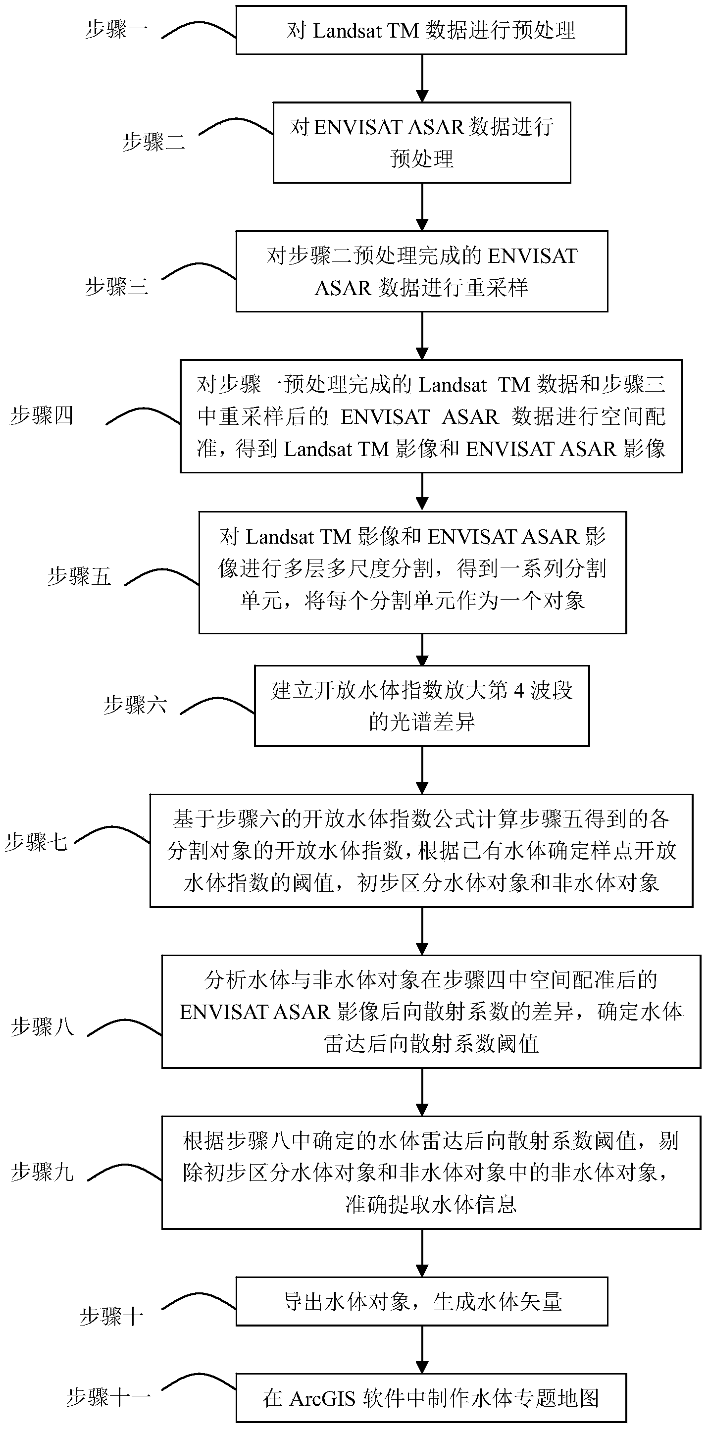
[0025] Specific embodiment one: a kind of object-oriented method for extracting water bodies based on ENVISAT ASAR and Landsat TM remote sensing data of the present embodiment, it is realized according to the following steps:

[0026] Step 1: Preprocessing the Landsat TM data;

[0027] Step 2: Preprocessing the ENVISAT ASAR data;

[0028] Step 3: Resample the ENVISAT ASAR data preprocessed in Step 2. Resampling criteria: the grid size of the resampled ENVISAT ASAR data is consistent with that of the Landsat TM data processed in Step 1;

[0029] Step 4: Perform spatial registration on the Landsat TM data preprocessed in step 1 and the resampled ENVISAT ASAR data in step 3 to obtain Landsat TM images and ENVISAT ASAR images;

[0030] Step 5: Carry out multi-layer and multi-scale segmentation on the Landsat TM image and ENVISAT ASAR image to obtain a series of segmentation units, and take each segmentation unit as an object; wherein, each segmentation unit consists of spatially ...

specific Embodiment approach 2

[0039] Embodiment 2: This embodiment differs from Embodiment 1 in that: in the first step, the Landsat TM data is preprocessed using orthorectification and geometric fine correction to eliminate terrain distortion and geometric distortion.

[0040] Other steps and parameters are the same as those in Embodiment 1.

specific Embodiment approach 3

[0041] Specific embodiment three: the difference between this embodiment and specific embodiment one or two is that: in the step two, the ENVISAT ASAR data (this data is grid format data, stored in matrix form) is preprocessed using radiation calibration, Terrain correction and filtering processing, the numerical quantization value of the image is DN ij Values ​​are converted into backscatter coefficients to eliminate image terrain distortion, geometric distortion and noise;

[0042] Wherein, the radiation calibration formula is as follows:

[0043] σ ij 0 = 10 · log 10 [ DN ij 2 K sin ( θ ij ) ] ;

[0044] in, is the backscatter coefficient of the pixel in row i ...


PUM


Abstract

The invention discloses an object-oriented water-body extracting method based on ENVISAT ASAR and Landsat TM remote sensing data, and relates to an object-oriented remote sensing image sorting method based on ENVISAT ASAR and Landsat TM remote sensing image data. The invention aims at overcoming the problems that the existing method for extracting water-body information by remote sensing images is low in extraction precision, complex and difficult to operate. The method comprises the steps of: 1 and 2, preprocessing data; 3, resampling ENVISAT ASAR data; 4, performing space rectification on data; 5, performing multi-level multi-scale segmentation on images; 6, establishing an open water-body index to amplify spectrum difference of a fourth wave band; 7, tentatively distinguishing water-body objects and non-water-body objects; 8, determining a water-body radar backscattering coefficient threshold value; 9, accurately extracting water-body information; 10, leading out the water-body objects, and generating water-body vectors; and 11, making a water-body thematic map.

Description

technical field [0001] The invention relates to an object-oriented remote sensing image classification method based on ENVISAT ASAR and Landsat TM remote sensing image data. Background technique [0002] Water is the source of life for all things on earth, and the extraction of water bodies is the basis for many aspects such as investigation and evaluation of water resources, prediction and investigation of flood disasters and loss assessment, environmental monitoring, water quality monitoring, and drought assessment. Therefore, it is of great significance to quickly and accurately draw thematic maps of the spatial distribution of water bodies for the protection, monitoring and evaluation of water resources. However, in the existing methods of extracting water body information from remote sensing images, the simple and easy water body extraction methods often have low extraction accuracy, and the high-precision water body extraction methods are often complicated and difficul...

Claims


Application Information

Patent Timeline
IPC IPC(8): G06T7/00G06F17/50
Inventor 路春燕王宗明贾明明刘明月毛德华
Owner NORTHEAST INST OF GEOGRAPHY & AGRIECOLOGY C A S
Learn More