
Remote sensing sub-pixel map-making method based on integrated pixel level and sub-pixel level spatial correlation characteristics

A spatial correlation, sub-pixel technology, applied in the field of geospatial information, can solve problems such as increasing the complexity of calculation, and achieve the effect of simple calculation

Inactive Publication Date: 2015-01-07
INST OF GEOGRAPHICAL SCI & NATURAL RESOURCE RES CAS
View PDF3 Cites 12 Cited by
  • Summary
  • Abstract
  • Description
  • Claims
  • Application Information

AI Technical Summary

Problems solved by technology

However, these two methods use the two spatial correlation features separately without comprehensive consideration at the same time, including Wang et al. (2012a) and Ling et al. (2013). Obtaining spatial correlation features in pixels instead of pixel-level spatial correlation features can be regarded as spatial correlation features extracted from sub-pixel mapping results in a sense, and it also increases the complexity of calculation

Method used


Image

  • Remote sensing sub-pixel map-making method based on integrated pixel level and sub-pixel level spatial correlation characteristics
  • Remote sensing sub-pixel map-making method based on integrated pixel level and sub-pixel level spatial correlation characteristics
  • Remote sensing sub-pixel map-making method based on integrated pixel level and sub-pixel level spatial correlation characteristics

Examples


Embodiment Construction

[0029] The present invention will be further described below in conjunction with the accompanying drawings and specific embodiments.

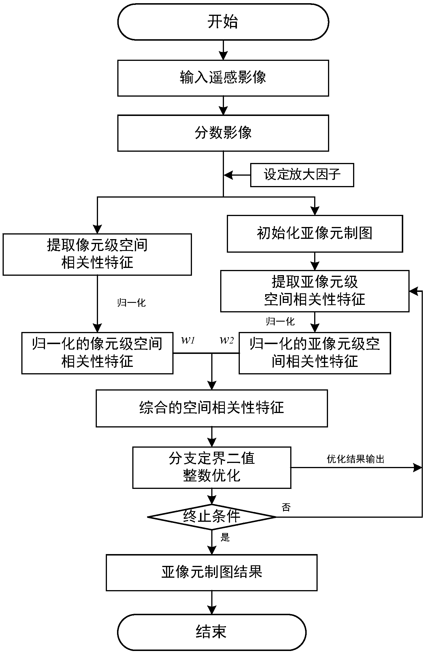
[0030] Such as figure 1 Shown, the specific implementation process of the present invention is as follows:

[0031] Step 1. Preprocess remote sensing data to obtain fractional images.

[0032] Usually, the real remote sensing images need to be preprocessed by geometric correction, atmospheric correction and denoising. The proportion, that is, the fractional image, is used as the input data for sub-pixel mapping. Since there are often errors in the soft classification process, in order to avoid the errors in the soft classification process from affecting sub-pixel mapping, this section uses simulated images to describe the specific implementation process of sub-pixel mapping. By drawing a vector map containing 4 types of ground objects and converting it into a raster map (such as figure 2 As shown in (a), its size is 240×240 pixels, which i...


PUM


Abstract

The invention discloses a remote sensing sub-pixel map-making method based on integrated pixel level and sub-pixel level spatial correlation characteristics. The method includes the steps that firstly, a frequently-used pixel level spatial correlation characteristic description method (a spatial attraction model) is utilized for extracting pixel level spatial correlation characteristics from soft classification information (category proportions) of a neighborhood pixel easily and rapidly without iteration; secondly, a widely-used sub-pixel level spatial correlation characteristic description method (an exponential decay model) is utilized for extracting sub-pixel level spatial correlation characteristics from a sub-pixel map-making iteration result; then, the spatial correlation characteristics of the pixel level and the sub-pixel level are normalized and fused to obtain the integrated spatial correlation characteristic value used for determining the sub-pixel categorical attribute; finally, the optimal spatial layout of the sub-pixel with the largest sum of all the category spatial correlation characteristic values in mixed pixels is obtained according to the integrated spatial correlation characteristic value through a classical binary branching-bounding integer programming algorithm. The remote sensing sub-pixel map-making method is high in calculation speed and simulation precision.

Description

technical field [0001] The invention relates to a sub-pixel mapping method, which belongs to the technical field of geospatial information. Background technique [0002] In recent years, the extraction of land use / land cover thematic maps (image classification) from digital remote sensing images has become a hot field in remote sensing technology research. However, in the process of remote sensing image acquisition, due to the complexity of the surface, the influence of the external environment, and the limitations of the sensor itself, mixed pixels (Mixed Pixel) commonly exist in the image. In the process of remote sensing classification, the traditional hard classification method only assigns each pixel a kind of ground object category, which will cause inaccurate results and limit its in-depth application when dealing with mixed pixels. The soft classification method is proposed to obtain the category proportion of each object in the mixed pixel (also called percentage, ...

Claims


Application Information

Patent Timeline
Patent Type & Authority Applications(China)
IPC IPC(8): G06K9/62G06K9/46
CPCG06T11/00
Inventor 陈跃红葛咏江昱胡建龙
Owner INST OF GEOGRAPHICAL SCI & NATURAL RESOURCE RES CAS
Learn More