Panorama-based outdoor movement augmented reality method for accurately marking POI

An augmented reality and panorama technology, applied in the computer field, can solve problems such as huge pre-workload, and achieve the effects of narrowing the search range, good user experience, and smooth running user experience

Active Publication Date: 2015-02-25
BEIJING INSTITUTE OF TECHNOLOGYGY
View PDF3 Cites 35 Cited by
  • Summary
  • Abstract
  • Description
  • Claims
  • Application Information

AI Technical Summary

Problems solved by technology

However, this method needs to reconstruct the 3D data of large-scale outdoor scenes in advance, and establish the relationship between the 3D points of the scene and the 2D images related to the scene, which requires a huge amount of pre-work.

Method used


Image

  • Panorama-based outdoor movement augmented reality method for accurately marking POI
  • Panorama-based outdoor movement augmented reality method for accurately marking POI

Examples


Embodiment Construction

[0024] In order to make the object, technical solution and beneficial effects of the present invention more clear, the present invention will be further described in detail below in conjunction with the accompanying drawings and embodiments. It should be understood that the specific embodiments described here are only used to explain the present invention, not to limit the present invention.

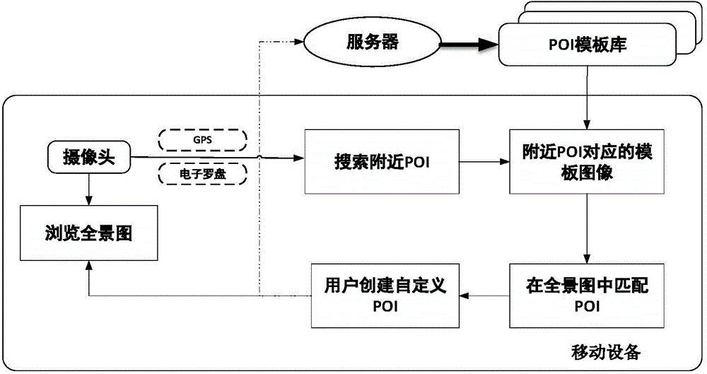
[0025] In the embodiment of the present invention, the embodiment of the system designs an outdoor mobile augmented reality technical solution based on panoramas to accurately mark points of interest. This technical solution can analyze and identify the POI image in the image according to the panoramic image taken by the user through the mobile terminal, and then calculate the exact position of the POI image in the panoramic image generated by the current user, and display the corresponding POI image on the mobile client. The location is identified, and then the POI name information is a...


PUM


Abstract

The invention provides a panorama-based outdoor movement augmented reality method for accurately marking a POI. A panorama is generated on line at the current site where a user is located, and a POI template image which is placed in a server side in advance is matched to the panorama generated on line through a template matching algorithm; meanwhile, the POI template image is roughly positioned in the panorama by calculating the azimuth angle between the current position and the POI in the process, and the searching range of the template matching algorithm is effectively decreased; after recognition is finished, the user can select an interesting area in the generated panorama, personalized augmented reality labels such as words, sounds and a GPS are added to the interesting area, and the interesting area is uploaded to a server to be used as POI information base expansion. According to the panorama-based outdoor movement augmented reality method for accurately marking the POI, the brand-new implementation way is provided for outdoor movement augmented reality, and the user can visually obtain the augmented reality information and deepen the understanding of the surrounding environment by accurately marking POI information on the panorama of the current position where the user is located.

Description

technical field [0001] The invention belongs to the technical field of computers and relates to an outdoor mobile augmented reality method for accurately marking points of interest based on a panorama. Background technique [0002] Augmented Reality (Augmented Reality, AR), as a current research hotspot in the field of computer vision, is a technology that uses additional information generated by computers to enhance or expand real-world scenes. Comprehension and perception of real-world environments. The mobile terminal-based outdoor augmented reality system combines location-based services (Location Based Services, LBS), determines the user's actual geographic location through the mobile terminal, and provides users with nearby street views, shopping, commercial hotspots and other points of interest (Point of Interest, POI). ) information, allowing users to quickly adapt to unfamiliar environments and complete augmented reality real-scene navigation. [0003] Traditional...

Claims


Application Information

Patent Timeline
Patent Type & Authority Applications(China)
IPC IPC(8): G06F17/30
CPCG06F16/29
Inventor 梁杏陈靖蔡珺
Owner BEIJING INSTITUTE OF TECHNOLOGYGY
Why Eureka
Try Eureka