Region scale soil erosion modeling-oriented terrain factor parallel computing method

A soil erosion, regional scale technology, applied in computing, special data processing applications, instruments, etc., can solve problems such as the inability to efficiently extract terrain factors for regional scale soil erosion modeling, and achieve parallel efficiency, fast and accurate calculation. Effect

Inactive Publication Date: 2015-03-04
NANJING NORMAL UNIVERSITY
View PDF4 Cites 12 Cited by
  • Summary
  • Abstract
  • Description
  • Claims
  • Application Information

AI Technical Summary

Problems solved by technology

[0005] The technical problem to be solved by the present invention is that, aiming at the inability of the existing serial algorithm to efficiently extract topographic factors for regional-scale s

Method used


Image

  • Region scale soil erosion modeling-oriented terrain factor parallel computing method
  • Region scale soil erosion modeling-oriented terrain factor parallel computing method
  • Region scale soil erosion modeling-oriented terrain factor parallel computing method

Examples


Embodiment Construction

[0035] The present invention will be further described in detail below in conjunction with the drawings and specific embodiments.

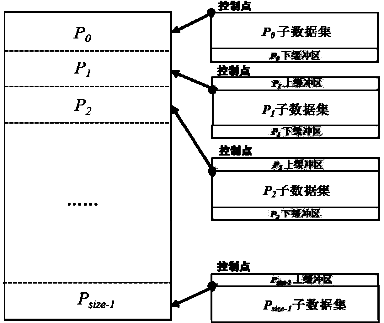
[0036] 1. Data division strategy

[0037] The present invention adopts a stripe division method. The basic idea is to divide the original data into sub-data blocks of equal data rows according to the number of processes of the parallel algorithm. Each sub-data block mainly contains three elements: (1) Data Area: the data area that can be allocated by the computing node; (2) Control point: used to locate the starting reading and writing position of each data block; (3) Buffer: each sub-data block is attached with two upper and lower buffers ( For the first sub-data block there is only a lower buffer, and the last data block has only an upper buffer). On the one hand, the buffer can solve the problem of accessing data across data, and it can also be used to transfer calculation results between processes. (Such as figure 1 Shown)

[0038] Second, the alg...


PUM


Abstract

The invention discloses a region scale soil erosion modeling-oriented terrain factor parallel computing method and belongs to the technical field of computers and information. The method comprises the following steps: (1) determining a data partitioning strategy, and performing equal-row partitioning on original terrain data by a row buffer zone partitioning method according to the number of parallel nodes, wherein each sub data block comprises three elements of a data zone, a buffer zone and a control point; (2) performing slope parallel computing, water flow direction computing, flow accumulation computing, river network extraction computing, slope length computing and slope-slope length factor computing based on preprocessed DEM (digital elevation model) data according to the data partitioning strategy. According to the method, the computing characteristics of a serial algorithm are fully considered in the design process of a parallel algorithm; different parallel strategies are designed for a local algorithm and a global algorithm respectively; the parallel efficiency of the algorithms is effectively improved; terrain factors based on mass terrain data can be quickly and accurately computed.

Description

Technical field [0001] The invention belongs to the field of computer and information technology, and in particular relates to a method for parallel calculation of terrain factors for regional soil erosion modeling. Background technique [0002] Soil erosion is a major environmental problem faced by all mankind, and terrain elements play an important role in controlling the occurrence and development of soil erosion, and it is also one of the indispensable factors in existing soil erosion models. Current scholars generally use slope and length factors to express the influence of terrain elements on soil erosion. The slope length factor includes two parts: slope factor and slope length factor. Among them, the extraction of slope length is a difficult point. Scholars such as Hickey, Van Remortel, Zhang Hongming, etc., based on Digital Elevation Models (DEM), proposed and developed an erosion process-oriented slope length extraction method, which has been obtained in the prediction...

Claims


Application Information

Patent Timeline
IPC IPC(8): G06F19/00
Inventor 汤国安刘凯江岭蒋如乔黄骁力
Owner NANJING NORMAL UNIVERSITY
Why Eureka
Try Eureka