GPS/INS-based dynamic pointing method

A technology of dynamic pointing and GPS receiver, applied in the directions of instruments, navigation, surveying and navigation, etc., which can solve problems such as poor controllability and reliability, and inability to perform positioning.

Inactive Publication Date: 2015-03-25
SHANDONG UNIV
View PDF1 Cites 15 Cited by
  • Summary
  • Abstract
  • Description
  • Claims
  • Application Information

AI Technical Summary

Problems solved by technology

[0003] As the core of the capture technology, the initial pointing method has attracted the attention and research of many scholars. For example, in the application number 201310499230.2, the invention name is "A method for initial alignment in the air with strapdown inertial navigation of floating aircraft", and the inventors are Li Baoguo and Lu Jiazhen In the inventions of , Hu Wenyuan, and Wu Meng, the

Method used


Image

  • GPS/INS-based dynamic pointing method
  • GPS/INS-based dynamic pointing method
  • GPS/INS-based dynamic pointing method

Examples


Embodiment

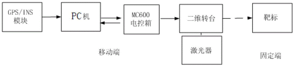
[0053] Examples of the present invention figure 1 As shown, a dynamic pointing method based on GPS / INS is implemented by the mobile terminal on the ground. The mobile terminal mainly includes GPS / INS module, PC, two-dimensional turntable, MC600 electric control box and laser, GPS / INS module Including GPS receiver and inertial navigation system module, GPS / INS module and MC600 electric control box are connected to PC respectively, MC600 electric control box is controlled by 32-bit DSP processor, MC600 electric control box is connected to the two-dimensional turntable The azimuth axis and pitch axis of the two-dimensional turntable can realize single-axis and dual-axis control of the azimuth and pitch axes of the two-dimensional turntable; the laser is fixed on the two-dimensional turntable and rotates with the azimuth axis and pitch axis on the two-dimensional turntable to complete the fixed The specific steps of the dynamic pointing method are as follows:

[0054] (1) Acquis...


PUM


Abstract

The invention belongs to the technical field of laser communication pre-pointing capturing and discloses a GPS/INS-based dynamic pointing method. In a GPS/INS combined system, GPS data serve as outer input, INS system errors accumulated along with time are adjusted, and an INS is constantly amended when a carrier moves. The GPS/INS-based dynamic pointing method can solve the problem that GPS signals are lost under the dynamic condition through the INS computed data, and the signal capturing and tracking capacity of a GPS receiver is enhanced. The GPS/INS combined system plays a role in complement, the anti-interference capacity is higher and the precision is higher. The GPS/INS combined system is applied in the pre-pointing technology, the pointing angle value pointing to a target is worked out through the position information, obtained by a GPS, of a ground fixed end target, the movement platform three-axis attitude information and position information which are obtained by real-time measurement of the GPS/INS navigation system, corresponding coordinate conversion and real-time computing, and a two-dimension rotary table can rotate according to the pointing angle value to point to the target in real time.

Description

technical field [0001] The invention relates to a dynamic pointing method based on GPS / INS, in particular to a dynamic pointing method for obtaining a pointing angle by solving real-time updated GPS / INS data, and belongs to the technical field of laser communication pre-pointing capture. Background technique [0002] The laser communication system based on the motion platform, due to the long communication distance, narrow beam and external interference (atmospheric influence, platform angular motion and vibration, etc.), the motion platform must adopt acquisition (Acquisition), tracking (Tracking) and aiming (Pointing) technology (ATP) to establish and maintain an optical communication link to the fixed-end target. Among them, the acquisition technology is used as a prerequisite for tracking and targeting, and is used to quickly establish a laser communication link or restore an interrupted communication link. Whether the field of view of the ATP (acquisition, tracking and...

Claims


Application Information

Patent Timeline
IPC IPC(8): G01S19/49
CPCG01C21/165G01S19/49
Inventor 朱维红杨宝华王娟娟田晓亮
Owner SHANDONG UNIV
Why Eureka
Try Eureka