Cadastral surveying system and method achieving automatic cadastral mapping

An automatic mapping and survey system technology, applied in geographic information databases, special data processing applications, instruments, etc., can solve problems such as complicated internal work, cumbersome external work process, and backward technical methods to ensure coherence and consistency Features, clear functional division, and enhanced data management

Inactive Publication Date: 2015-03-25
SOUTHEAST UNIV
View PDF5 Cites 25 Cited by
  • Summary
  • Abstract
  • Description
  • Claims
  • Application Information

AI Technical Summary

Problems solved by technology

[0004] (1) Carrying too many paper materials increases the cost of cadastral survey and the difficulty of operation
[0005] (2) The field operation process is cumbersome, the cycle is long, and there is a lack of unified and effective data management
[0006] (3) The connection between internal and external business is not smooth, the internal work is complicated, the workload is heavy, and error-prone
[0007] (4) There is a lack of unified cadastral information management in the internal industry, and the degree of informatization and automation is low
[0008] In recent years, new technologies for land survey have also appeared, such as portable device information collection technology and high-precision network positioning technology, but the technical methods for the field of cadastral survey business are still relatively backward, and there is a lack of systematic and effective methods to support new technologies in Applications in the field of cadastral surveys
Although the coding mapping method adopted by the CASS software combined with the total station has made up for the shortcomings of the current technical methods to a certain extent, the staff still need to perform complicated tasks such as mapping points, manual attribute entry, and cadastral map symbolization in the industry. , failed to fundamentally solve the problem of low automation after the informatization of cadastral survey techniques and methods

Method used


Image

  • Cadastral surveying system and method achieving automatic cadastral mapping
  • Cadastral surveying system and method achieving automatic cadastral mapping
  • Cadastral surveying system and method achieving automatic cadastral mapping

Examples


Embodiment Construction

[0057] The technical solution of the present invention will be described in detail below with reference to the drawings and embodiments.

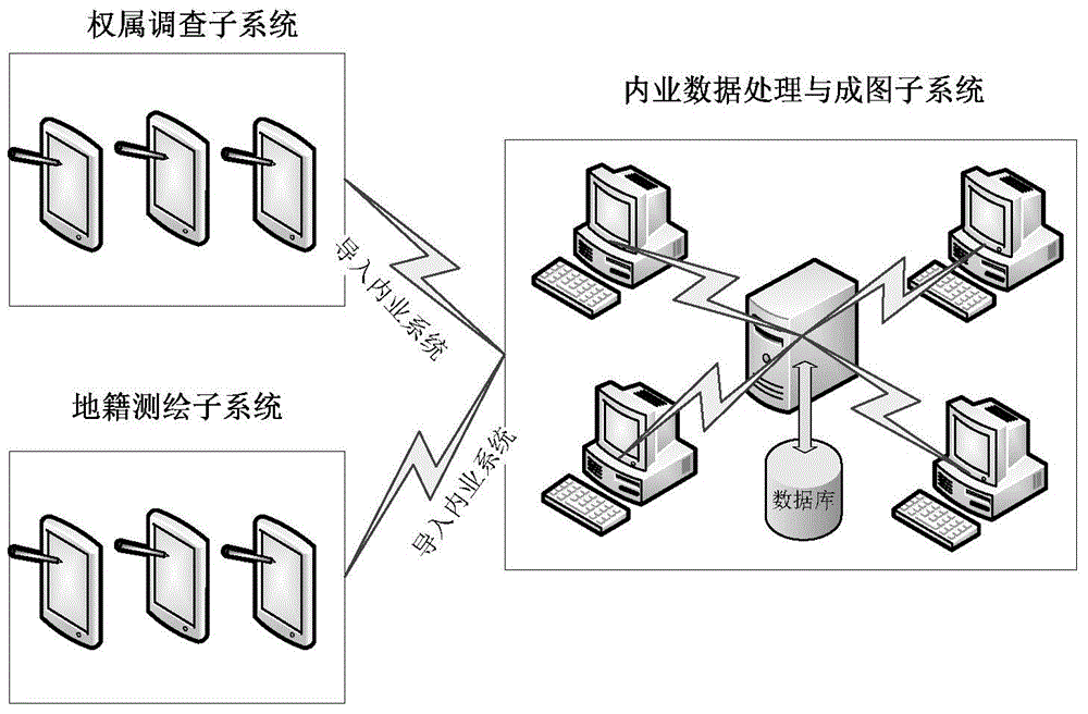
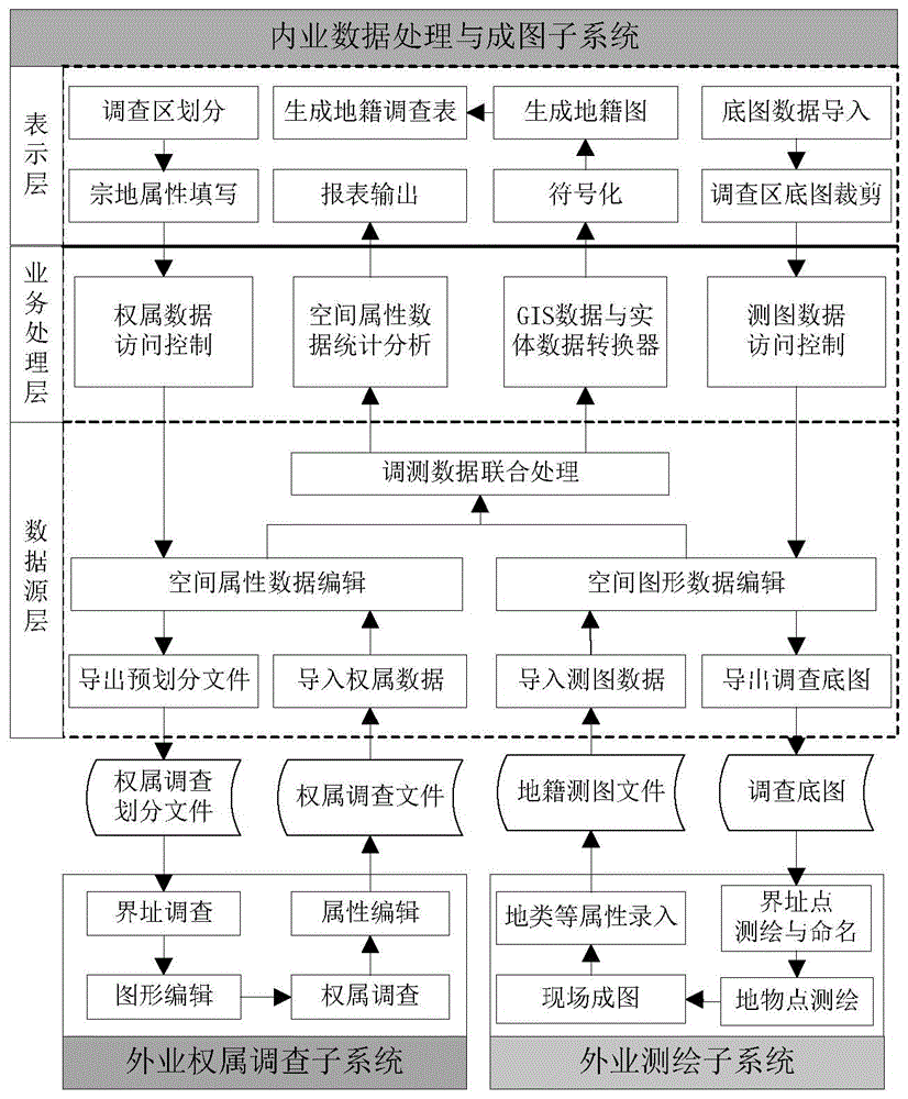
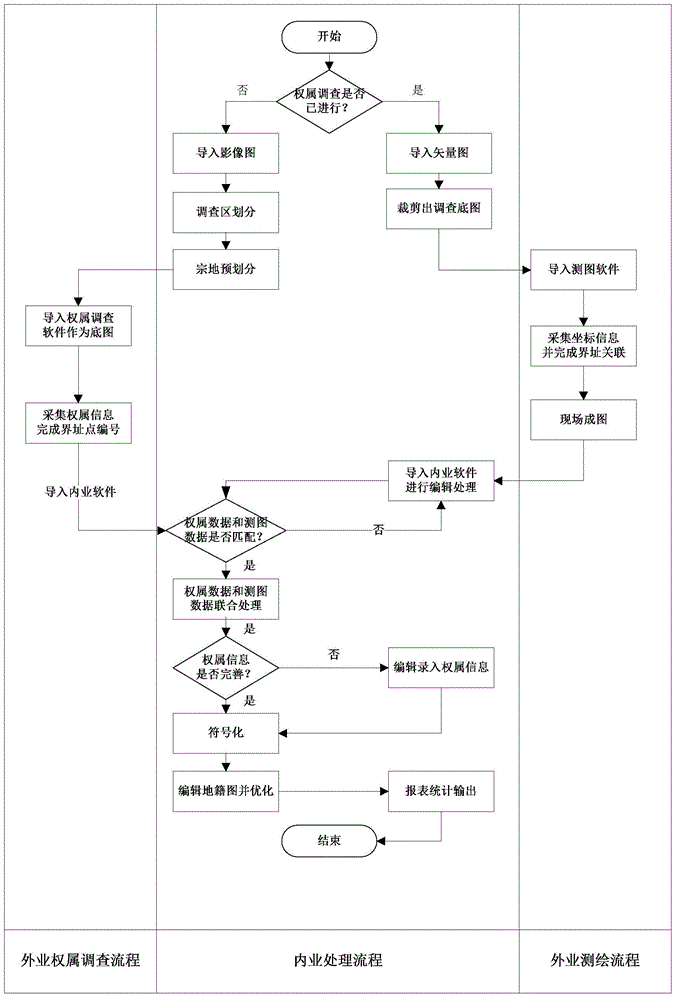
[0058] Such as figure 1 As shown, a cadastral investigation system of the present invention that realizes automatic mapping of cadastral maps includes internal data processing and mapping subsystems, and field ownership investigations that are connected to the internal data processing and mapping subsystems. subsystem and the field cadastral mapping subsystem.

[0059] In this embodiment, the field ownership investigation subsystem includes a mobile terminal and ownership information collection software installed on the mobile terminal. Save in a custom data storage format file.

[0060] The field cadastral surveying and mapping subsystem is composed of a mobile terminal integrated with a total station, GPS receiver and cadastral surveying and mapping software. It mainly completes coordinate collection, attribute entry and on-site mapping...


PUM


Abstract

The invention discloses a cadastral surveying system and method achieving automatic cadastral mapping. The system comprises an office work data processing and mapping subsystem, a field work ownership surveying subsystem and a field work cadastral plotting subsystem, wherein the field work ownership surveying subsystem and the field work cadastral plotting subsystem are communicated with the office work data processing and mapping subsystem; the field work cadastral plotting subsystem carries out field work plotting on the surveying result of the field work ownership surveying subsystem, the plotting result and the ownership surveying result are guided into the office work data processing and mapping subsystem for making a cadastral map, and automation of cadastral mapping is achieved according to field results. The data management is enhanced, surveying data, the field surveying results and cadastral results are managed in a unified mode, automation of cadastral mapping is achieved, maps, data and on-site situations are coincident, the method is clear in division, the system operation is easy, and servicers can operate the system conveniently.

Description

technical field [0001] The invention relates to the field of cadastral ownership investigation, in particular to a cadastral investigation system and an investigation method for realizing automatic mapping of cadastral maps. Background technique [0002] With the development of society and economy and the increase of national demand for cadastral data, all localities have strengthened the construction of cadastral information systems, accelerated the automation and informatization of cadastral management, and realized the goal of "seeing in the sky, checking on the ground, and managing on maps" in land management. Comprehensive, timely and accurate grasp of land use information, ensuring the accuracy, current situation and basicity of cadastral results are the basis for improving land information participation in regulation and the premise of land automation and information management. [0003] The current main method of cadastral investigation is: investigators first collec...

Claims


Application Information

Patent Timeline
Patent Type & Authority Applications(China)
IPC IPC(8): G06F17/30
CPCG06F16/29
Inventor 王慧青吕志宏王庆余栋梁
Owner SOUTHEAST UNIV
Why Eureka
Try Eureka