Intertidal zone habitat survey method based on unmanned aerial vehicle aerial photography

A technology of intertidal zone and unmanned aerial vehicle, applied in the direction of image data processing, instruments, data processing applications, etc., can solve the problem of not meeting the fine-scale investigation of intertidal zone habitats, long construction period, and difficulty in accurately determining the range of intertidal zone habitats And other issues

Inactive Publication Date: 2015-03-25
EAST CHINA SEA FISHERIES RES INST CHINESE ACAD OF FISHERY SCI
View PDF4 Cites 19 Cited by
  • Summary
  • Abstract
  • Description
  • Claims
  • Application Information

AI Technical Summary

Problems solved by technology

The method of on-site biological survey is time-consuming and labor-intensive. Although the biological data at the sampling point can be obtained, it is difficult to accurately determine the habitat range of the intertidal zone as a whole; the traditional intertidal topographic survey requires manual beach surveys, and the workload is heavy And the construction period is long, and the measured parameters are only elevation information
Satellite remote sensing can quickly and large-scale simultaneous monitoring of land surface environmental changes, but limited by the spatial resolution of current satellite sensor imaging and the time of satellite transit imaging, the monitoring of intertidal zone terrain is limited to a large spatial scale, which cannot meet local A fine-scale survey of intertidal habitats

Method used


Image

  • Intertidal zone habitat survey method based on unmanned aerial vehicle aerial photography
  • Intertidal zone habitat survey method based on unmanned aerial vehicle aerial photography
  • Intertidal zone habitat survey method based on unmanned aerial vehicle aerial photography

Examples


Embodiment 1

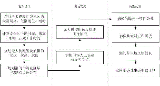
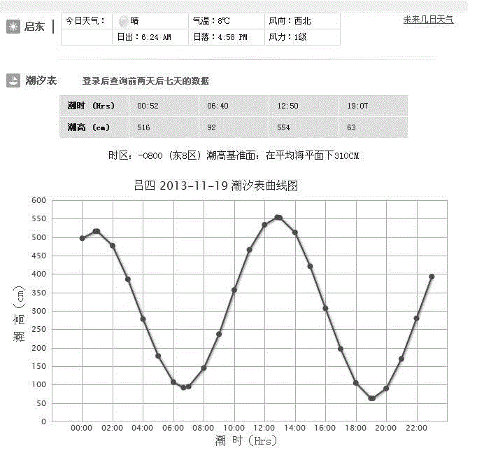
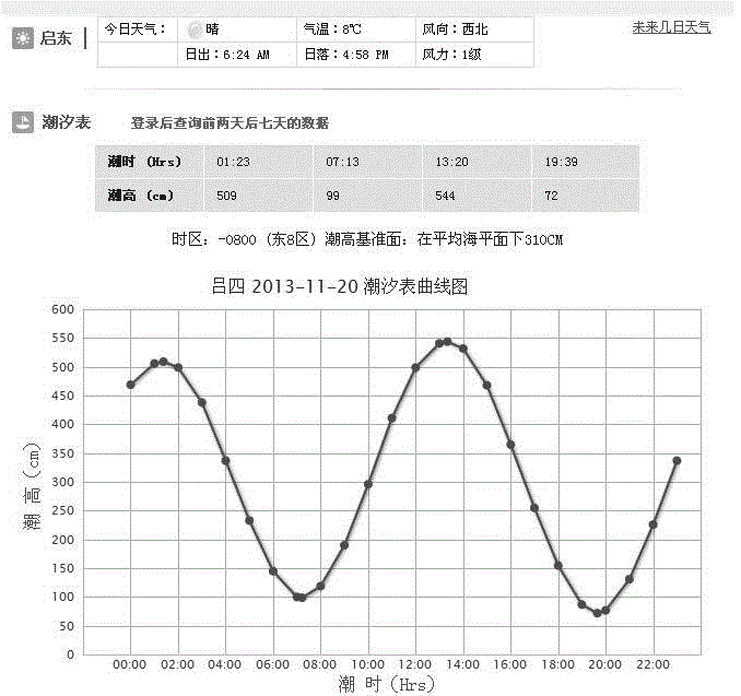
[0076] Embodiment 1: as figure 1 As shown, the following steps are included: In the research area, the UAV low-altitude aircraft is used as the remote sensing platform, and the UAV low-altitude aircraft can use a fixed-wing aircraft or a multi-rotor aircraft. The UAV low-altitude aircraft needs to be equipped with a digital camera and integrate a differential GPS and gyroscope attitude control module; query the tide table of the intertidal zone area to be investigated, and determine the specific time for the UAV aerial photography according to the spring tide period; according to the spring tide The exact time of the highest tide level and the lowest tide level of the period, determine the executable time period of the UAV aerial photography; according to the flight capability of the UAV, the shooting ability of the camera carried and the range of the intertidal zone to be investigated, plan the time period of the aerial photography Voyages and routes; according to the executa...


PUM


Abstract

The invention relates to an intertidal zone habitat survey method based on unmanned aerial vehicle aerial photography. The method comprises the steps that an unmanned aerial vehicle low-altitude aircraft is adopted as a remote sensing platform, needs to carry a digital camera, and integrates a GPS and a gyroscope module; a tidal table of a surveyed intertidal zone region is inquired; executable time periods of unmanned aerial vehicle aerial photography are determined according to high and low tide levels and tide time of a spring tide period; flight numbers and air lines of the aerial photography and control points needing to be arranged are planned; arrangement of the control points, measurement and aerial flight photography are completed; aerial photography images are processed, exposure adjusting, image splicing and geometric correcting are involved in processing, and therefore a high-resolution image of the whole survey range can be formed; speckle extracting and spatial formation ecological parameter calculating are carried out on specific type of the intertidal zone habitat. The method overcomes the defect of an existing intertidal biology survey method or a traditional topographic survey method, obtains spatial framework information of the intertidal habitat, and provides the basis for evaluating the ecological function and the ecological value of the inter-tidal habitat.

Description

technical field [0001] The invention relates to the fields of remote sensing information technology and ecological environment assessment, in particular to an intertidal zone habitat investigation method based on unmanned aerial vehicle photography. Background technique [0002] The intertidal zone refers to the coast between the highest tide level of the spring tide period and the lowest tide level of the spring tide period, that is, the range from the submerged place when the sea water rises to the highest level to the surface when the tide recedes to the lowest level. The intertidal zone is the link between ocean and land. In marine ecology, the intertidal zone is a special habitat. The intertidal zone is affected by the alternation of seawater high tide and low tide, and the environment changes greatly, forming a unique biological habitat and nurturing special intertidal zone organisms, which has important ecological significance and functions. In the estuary, the inte...

Claims


Application Information

Patent Timeline
Patent Type & Authority Applications(China)
IPC IPC(8): G06Q10/06G06T7/00
CPCG06Q10/06
Inventor 周为峰樊伟全为民
Owner EAST CHINA SEA FISHERIES RES INST CHINESE ACAD OF FISHERY SCI
Why Eureka
Try Eureka