High-resolution remote sensing image cloud height detection method

A remote sensing image, high-resolution technology, applied in the system field, can solve problems such as unsuccessful application, and achieve the effect of improving accuracy

Inactive Publication Date: 2015-04-01
ZHEJIANG UNIV
View PDF4 Cites 7 Cited by
  • Summary
  • Abstract
  • Description
  • Claims
  • Application Information

AI Technical Summary

Problems solved by technology

[0003] The specific idea of ​​using stereo vision to detect cloud height was proposed by scholars in the 1980s, but due to the limitation of the ability of satellites to acquire and process stereo vision data at that time, this method was not successfully applied

Method used


Image

  • High-resolution remote sensing image cloud height detection method
  • High-resolution remote sensing image cloud height detection method
  • High-resolution remote sensing image cloud height detection method

Examples


Embodiment Construction

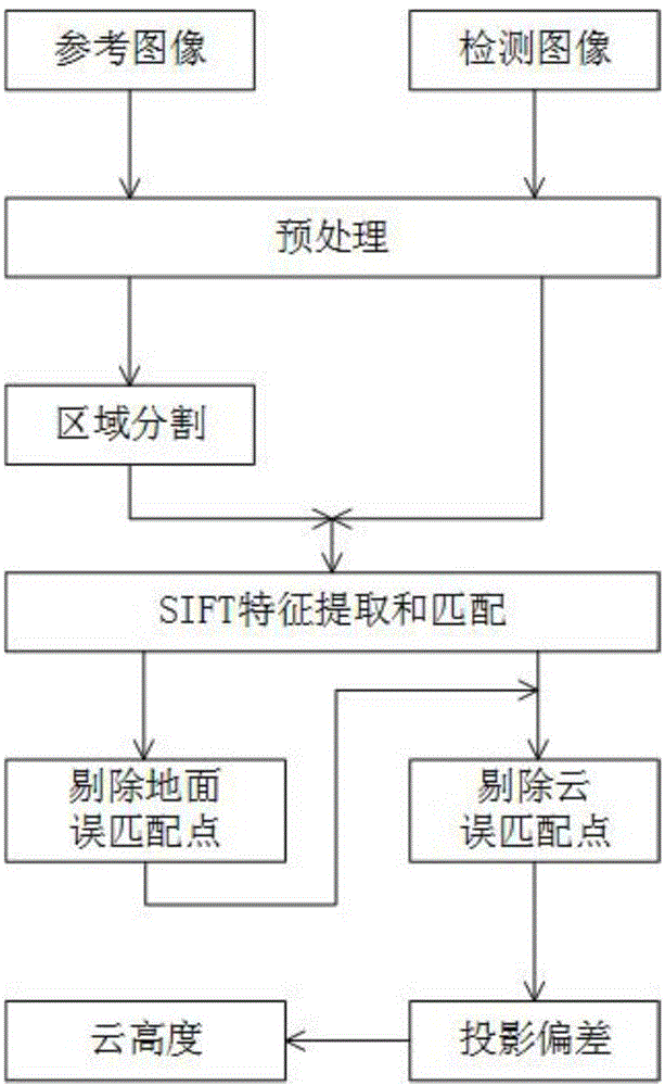
[0019] The specific steps of the present invention will now be further described in conjunction with the embodiments and drawings:

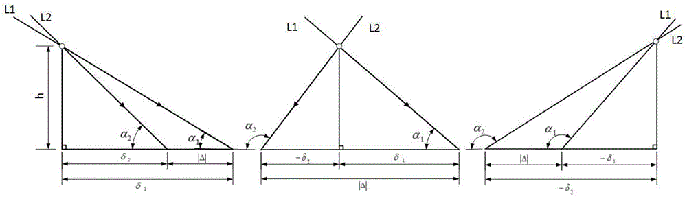
[0020] First, the mathematical model is explained. For high-resolution satellites, the angle of view is usually small, as shown in Figure 3(a), so the satellite’s object-side imaging light can be regarded as parallel light, and the imaging ground can be regarded as a plane; at the same time, the interval between two imaging Very short, the movement of the cloud is negligible. figure 2 It is a schematic diagram of the projection of a point on the cloud to the ground along the two imaging optical axis. Suppose the vertical projection point of the cloud to the ground is the origin of the coordinate, and the right direction is the positive direction, and the angle between the optical axis and the ground is defined as the angle with the negative direction; where h is the cloud height and α 1 , Α 2 Is the angle between the optical axis and the ground, δ ...


PUM


Abstract

The invention provides a high-resolution remote sensing image cloud height detection method. According to the method, the cloud height can be detected out through inputting two remote sensing images of the same objective at two different angles. Firstly, the input images are segmented into three parts: the ground, the cloud and the cloud and ground; then, an SIFT (scale invariant feature transform) matching algorithm is used for calculating the matching result of the ground and the cloud, and in addition, an RANSAC ((random sample consensus) algorithm is used for removing ground mismatching points to obtain the coordinate conversion relationship of the ground points of the two images; the conversion relationship of the ground points is used, the invention provides a method for removing cloud mismatching points by using cycles, and the projection deviation of the cloud to the ground can be accurately obtained; finally, the cloud height can be obtained by using a mathematical model according to the protection deviation and the known imaging angle of the two images. The high-resolution remote sensing image cloud height detection method has the advantages that the problem of matching precision reduction due to conversion of rotation, affinity and the like of the same cloud in images at different angles due to satellite attitude can be effectively solved, and the cloud height detection precision is improved.

Description

Technical field [0001] The invention relates to the technical fields of remote sensing image processing, stereo vision, feature matching and the like, and can be applied to systems such as multi-angle satellite imaging cloud height detection and satellite imaging capability prediction for specific targets. Background technique [0002] As an important part of satellite remote sensing images, cloud processing has always been the focus of remote sensing image processing. The height information of the cloud is one of the significant characteristics of the cloud. On the one hand, it can be used for short-term weather forecasting and long-term climate research. On the other hand, clouds often obscure ground targets and affect the satellite's ability to observe ground targets. Through the detection of cloud height information, it can quickly determine whether the satellite can observe a specific target, so that the satellite can work more efficiently and quickly obtain effective info...

Claims


Application Information

Patent Timeline
Patent Type & Authority Applications(China)
IPC IPC(8): G06K9/00G06K9/46
CPCG06V20/20
Inventor 陈跃庭孔祥海徐之海李奇冯华君
Owner ZHEJIANG UNIV
Why Eureka
Try Eureka